
A Look at the Six Options
As mentioned in the NZTA and AT Seek Feedback on East-West Connections, NZTA are seeking feedback on the six options in improving the links between State Highway 20 at Onehunga and State Highway One at Mt Wellington which houses the Onehunga/Southdown heavy industrial complex – the largest in Auckland if not New Zealand.
When I wrote the previous post the large versions of the graphics for each of the options was not work. Now they are and you can see them below:
The Options
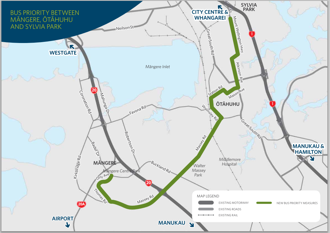
Bus priority between Māngere, Ōtāhuhu and Sylvia Park
Public transport between Māngere, Ōtāhuhu and Sylvia Park will be improved by providing bus priority along sections of the existing road.
|
|
Overview:
|
Improving connections into and out of Onehunga-Penrose
Option A: Existing route upgrade
This option looks to upgrade the existing roads. This includes improving capacity on SH20, Neilson and Church Streets. It also provides freight lanes.
 |
Overview:
|
Option B: Upgrade with South Eastern Highway ramp
This option proposes an upgrade of existing roads with a new ramp connection from Church Street to SH1 at South Eastern Highway.
 |
Overview:
|
Option C: Upgrade with new Galway Street and inland connections
This option proposes a new connection from Onehunga Harbour Road to Galway Street, an upgrade of Neilson and Angle Streets and Sylvia Park Road, and a new connection from Angle Street to Sylvia Park Road and to SH1.
 |
Overview:
|
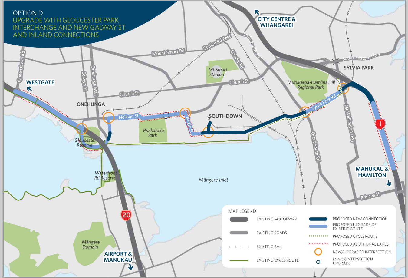
Option D: Upgrade with Gloucester Park interchange and new Galway St and inland connections
This option proposes an upgrade at Gloucester Park interchange and a new connection from Onehunga Harbour Road to Galway Street. It also proposes an upgrade of Neilson and Angle Streets and Sylvia Park Road, and a new connection from Angle Street to Sylvia Park Road and to SH1.
 |
Overview:
|
Option E: New foreshore connection
This option proposes a new connection from SH20 to SH1 along the foreshore.
 |
Overview:
|
Option F: New foreshore and inland connection
This option proposes a new connection from SH20 to SH1 (partly along the foreshore and partly inland).
 |
Overview:
|
Source for all graphics: http://www.nzta.govt.nz/projects/east-west-connections/overview.html
For the job required by this East-West Connection I quite like Option B with the State Highway 20 to Neilson Street upgraded connection to bypass the Onehunga Mall intersection (from Option C) put in place rather than what Option B has. Option B (modified) allows the best use of existing routes that serve the industrial complex with a new connection at State Highway One to bypass the Mt Wellington bottleneck. Option B is also the least of the destructive options (apart from A which really does not do anything) I can think of especially when compared to Options E and F which remind me a lot from what Option “8” was proposed by a lobby group.
One thing we all need to be on ‘Red Alert’ for is making sure Option Four – the motorway through Mangere option that was quickly ditched after protests leading to the Mayor ruling the option out entirely DOES NOT come back anywhere near the agenda at all. However, the NZ Council for Infrastructure Development is pushing for that motorway to be put back on that agenda AND built. Why? So East Auckland can get to the motorway a few minutes faster (while it rips the heart out of a South Auckland community). Something Option B and AMETI will do for those in Glen Innes while Te Irirangi Drive fitted either with a bus way or the Botany Sky Train would connect Howick to the Airport.
You can see NZCID’s presser on the situation here: http://www.scoop.co.nz/stories/AK1410/S00111/strategy-for-aucklands-east-west-connection-unclear.htm
Open days are coming up and feedback can be done by clicking the links below:
Please give us your feedback
We would like to hear your views on these options. Please come along to one of our open days, or complete ahardcopy (PDF, 5.05MB) or online feedback form. If you have any questions on any of these options please do not hesitate to contact us.
Open days
- Saturday 11 October, 10am – 1pm
- Onehunga Primary School Hall – 122 Arthur St, Onehunga
- Thursday 16 October, 3:30-7:30pm
- Otahuhu College Sports Pavilion -53 Mangere Road, Ōtāhuhu (opposite Otahuhu College)
- Sunday 19 October, 1 – 4pm
- Te Papapa Squash Club – Fergusson Park, Olea Road, Onehunga
Community workshops
We will also be holding a number of workshops on specific topics for those people who would like to provide more detailed feedback. To register for a workshop please email eastwest@nzta.govt.nz, or call us on 0508 NZTA EWC (0508 6982 392).
- Monday 20 October, 6:30-9pm, Onehunga
- Workshop topic: Māngere Inlet, Waikaraka walkway and Ann’s Creek
- Tuesday 21 October, 6:30-9pm, Onehunga
- Workshop topic: Onehunga town centre
- Wednesday 22 October, 6:30-9pm, Onehunga
- Workshop topic: Sylvia Park and Mutukaroa-Hamlins Hill
- Thursday 23 October, 6:30-9pm,Ōtāhuhu
- Workshop topic: Public transport between Māngere, Ōtāhuhu and Sylvia Park
Source: http://www.nzta.govt.nz/projects/east-west-connections/feedback.html

