
Debate on the Manukau Interchange
The Manukau South (Rail) Link debate is still going on over at Twitter between myself and few others. However in the progression in that debate, a new one cropped up and that is this new bus interchange Auckland Transport asked (in partnership) to be built as part of the MIT Manukau Campus (well was building – which has stalled by the Mainzeal Collapse – photos in a moment) and whether it is in the best location.
Currently buses (apart from one Howick and Eastern service which stops outside the entrance to the Manukau Station) stop outside the main entrance to the Westfield Manukau Mall, which happens to have its Food Court right there and there PLUS a McDonalds free-standing store 75 metres away in the corner. Once this new bus interchange is built (yes I know it has stalled – different matter), Auckland Transport would have the buses rerouted away from the existing stops and down to the interchange which is going to be in front of the (currently stalled) MIT Building on Davis Avenue. This means anyone that has caught a bus will have to join the Manukau Station train users in a 700 metre walk in the open air to get to the Westfield south entrance – which is on the opposite of the complex in relation to the mall’s food court!
I have commented on this kind of situation last year in my “Manukau does have its short comings” post in which Councillor George Wood “explored the area at the time and I followed up with commentary.
The graphic below shows where the existing bus interchange is and where the future one will be:
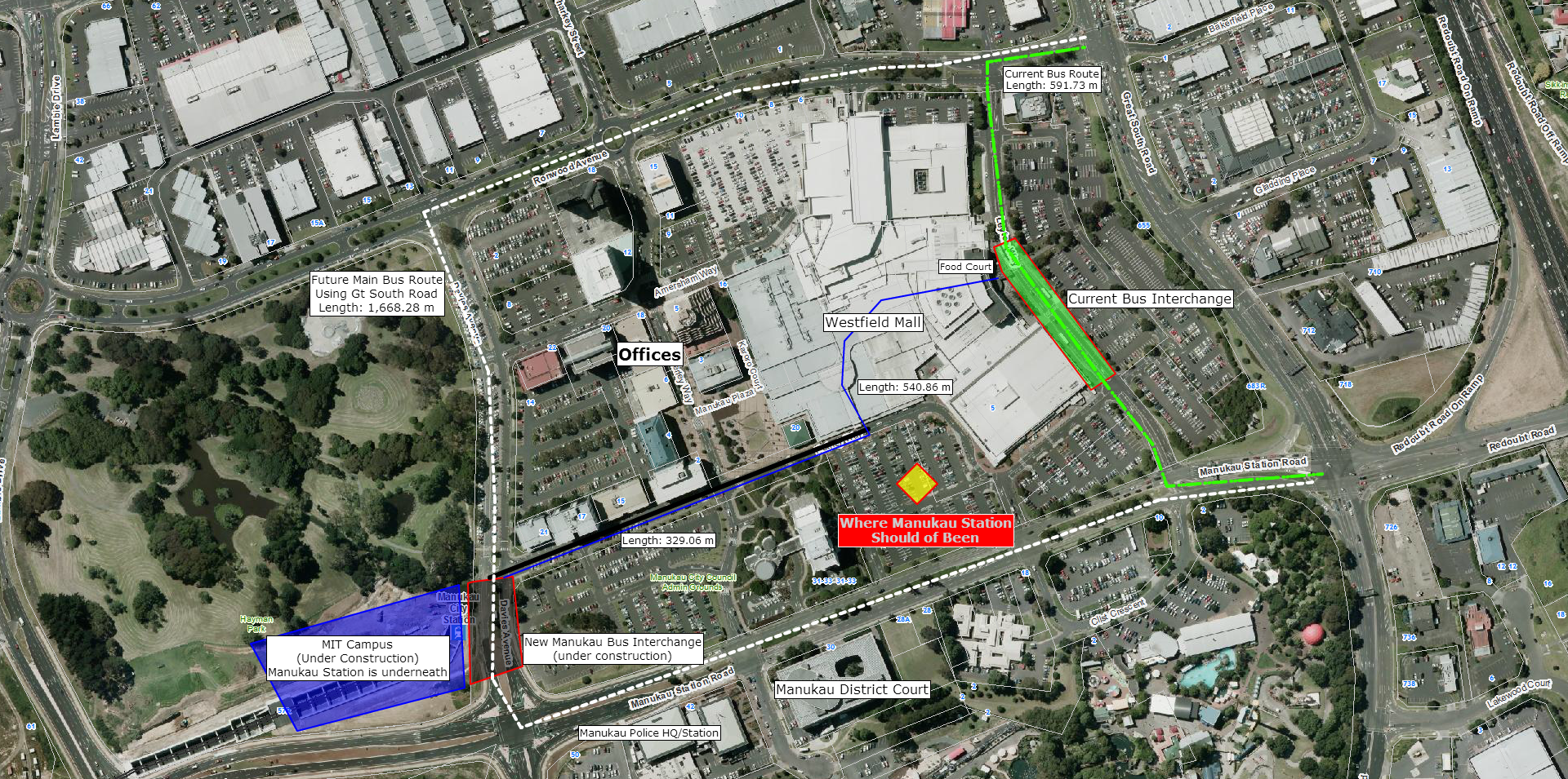
Click for full resolution
The obvious thing that came up and you might see come up yourself is that the Manukau Station is in the wrong place – WE KNOW! If someone had some spare cash floating around maybe we could “move” the station to where it should be and mothball the existing one. However I have moved on from the blame game and rather would work with what we have now to make it better – that matters more to residents and businesses 🙂 .
But the question asked is who are the interchanges trying to serve?
- Existing interchange is great for Westfield Mall, retailers and shoppers (especially the interchange being right next to the food court) but rather crap for office workers to the west of the Manukau City Centre area (Courts, Police HQ and Office Blocks). There is also a walk between a bus – train connection as well.
- The new interchange would: serve MIT, allow for direct Train – Bus Connection, closer access to the office blocks and the courts, but in return shoppers and retailers get lugged with a walk to an entrance that is not right on top of the food court.
The existing interchange is basically in full operation from the time the mall opens until late at night seven days a week as you get the off-peak and weekend flows. The new interchange would serve the peak well but near useless for off-peak (regardless of MIT) as I don’t see the family with young kids going for a walk from the interchange to the mall in a hurry.
So who are we trying to serve here? The Manukau South (Rail) Link would be an excellent indicator of shoppers willingness to walk (yep the South Link becomes the sacrificial lamb here) from the Manukau Station and Bus Interchange to Westfield Mall. If we run 20 minute frequencies in and out of Manukau Station via the South Link to Papakura and Pukekohe all day every day (7 days a week folks), passengers come shoppers might just be willing to walk that 329 metres to the Westfield Mall south entrance – providing AT got proactive and properly marked the route and made it sheltered!
Or as one person said on Twitter; use BOTH interchanges to capture maximum patronage via the bus and train. Yes I know that could make routes a bit more circuitous or give rise to new routes but could it allow maximum patronage to both the Mall, the Office Blocks and MIT? Something worth investigating?
I’ll have a ponder about it and see what I think.
However for the moment work needs to continue on the business case for the Manukau South Link while looking at options to have proper “signs and directions” to various places from the bus interchange. And maybe a covered walk-way from the interchange to the Mall for those winter howlers?
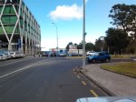
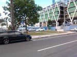
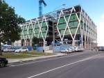
Finally here are some photos of the new Bus Interchange that was under construction until work stalled last Thursday:


Now that is an idea Bryce that had not entered my mind. And after being in Manukau again today your location idea for the bus interchange would seem most feasible to all. Hmm might raise with AT?
I think it makes the best of a bad idea and in future that car park must surely get developed so in the meantime a ‘temporary’ covered walkway could be suitable until it gets covered over by a mix of retail / residential.
Agreed.
“while looking at options to have proper “signs and directions” to various places from the bus interchange. And maybe a covered walk-way from the interchange to the Mall for those winter howlers? ”
And
Also I am sure I said somewhere (probably FB) something similar to you Bryce on getting that car park developed into retail and office space (or mix residential and retail/Office)
Why not put the bus interchange just to the West of the old council building. This would put it plumb between the mall (use the west entrance off Orsterley Way) and the train station. If necessary, a corridor with a moving walkway (like at airports) could be installed between the bus and rail terminals.
It also puts the interchange closer to the residential developments around the Orsterley Way area which I think is a plus.