
Councillor Quax looking at such a facility
He caught me by surprise yesterday commenting about it and I had to read the comment twice to make sure. Well today Councillor Dick Quax of the Howick Ward (and not exactly ally in the Council game) Tweeted this:
So “Could this be the site of Auckland’s future bus lanes along Ti Irirangi Drive from Manukau & Botany using the median?”
The answer is yes it can, especially as the median strip along Te Irirangi Drive was designed to both take a bus way at first and later the Botany (heavy or light rail) Line later on.
In essence Councillor Quax is looking at the Panmure to Manukau section of what is called the Botany Line bus way as seen here from the Congestion Free Network:

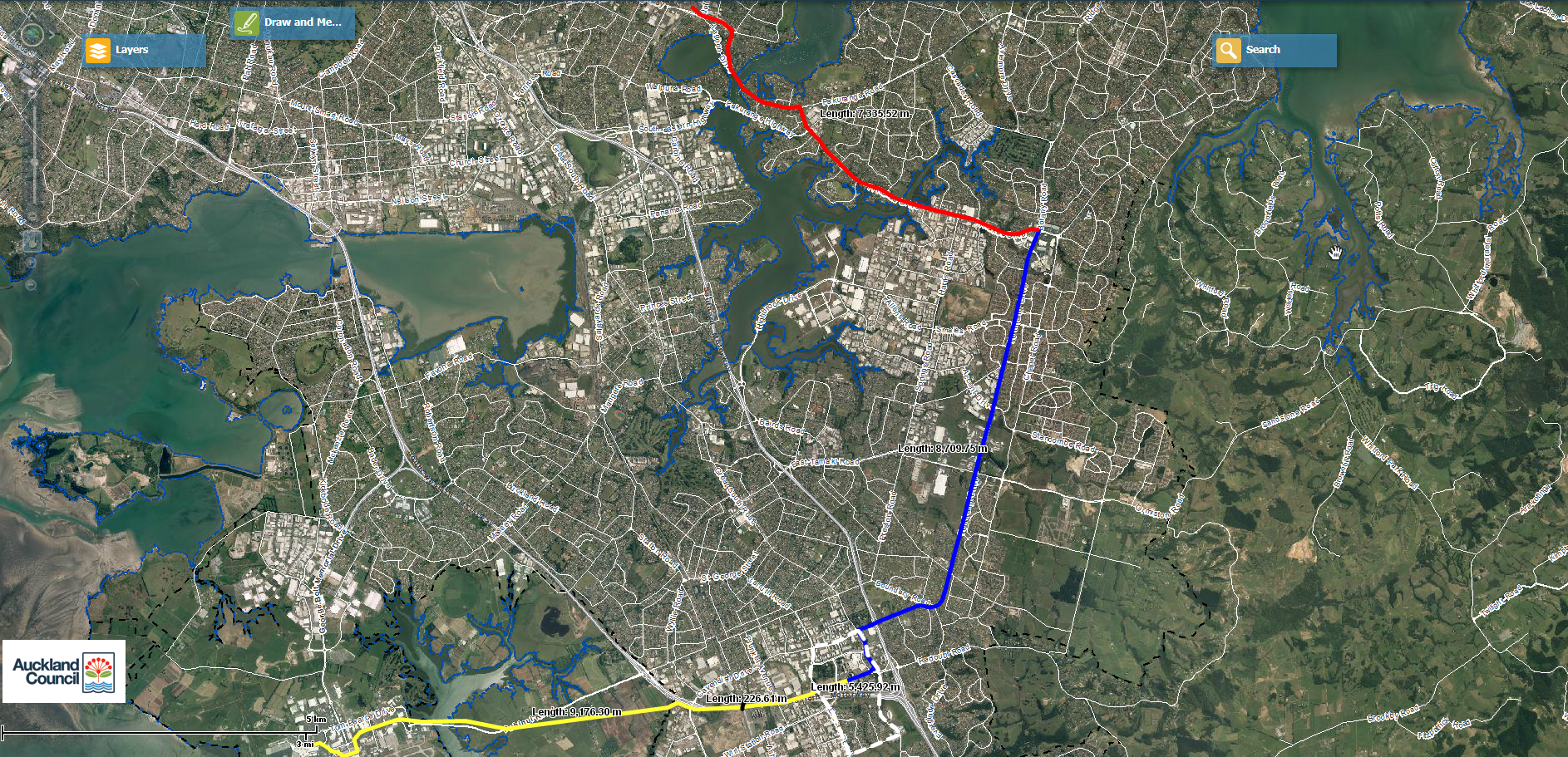
Or here (the blue and red lines):
While this does show the Sky Train for the Botany Line, for the most part (on the blue and red lines) the bus way would follow the same route as the Sky Train. The main deviation on the yellow Airport section would mean the buses follow State Highways 20 and 20B from Manukau to the Airport or the current 380 route through Papatoetoe from Manukau and then out to the Airport. More on the Botany Line Sky Train can be seen here: The Botany Line Sky Train which can be easily translated back as a bus way until demand is sufficient for the Sky Train (any time from 2020 onwards depending on population growth and the development of the Botany Metropolitan Centre and the Manukau Super Metropolitan Centre.
An extract from the Botany Line Sky Train which would applicable (for the most part) in translating back to the Te Irirangi Drive bus way Councillor Quax is supporting and wanting:
Manukau-Botany section (blue line) and Botany-Panmure section (red line)
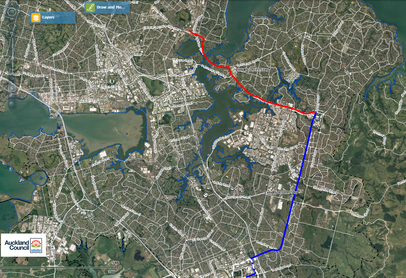
Click for full resolution
The Manukau to Botany section (blue line) would be the next section of the Sky Train system to be built. It is the second longest piece of the puzzle and is approximately 8.71km in length end-to-end.
This section links up Manukau City Centre with the Botany Metropolitan Centre – both forecast to take significant growth over the next thirty years. Again station locations are not picked as of yet but consideration will be given where maximum passenger capture within an area can be ensured.
The blue line section would be moderately difficult to be built owing to some tight turns as well as building alongside or within in two major thoroughfares: the Great South Road and Te Irirangi Drive. The fortunate part is though with the line and stations elevated the trains will never have to compete with road users at ground level. To make the situation a bit more easier is the fact Te Irirangi and the Great South Road are served by wide centre grass medians (especially Te Irirangi which was future proofed for the original Botany Line) so the elevated tracks and stations can be built on top of them rather than on the side of the road which runs the risk of demolishing buildings. The other beauty of running the track and stations down the centre medians is that it is easier to build over bridges to link either side of the road for pedestrians so that the pedestrians do not need to cross the often busy roads.
The blue (and red) sections of the Sky Train Line also carry in one other factor that makes construction more easier than otherwise normally. You can build the sections in pieces as finances and patronage allow. For example starting at Manukau you then build to the Rainbows End station, then to the Te Irirangi/Great South Road intersection, then to Boundary Road, and so on and so on until you reach Botany (or Panmure) itself. Building it in pieces minimises disruption along an entire sectional route as well as keeping costs (money and time down). For some reason Auckland seems to be better at building things in bite size pieces rather than the whole hog unless you want major blow outs somewhere. Only catch is that the idea is once one section of the line is built, the next one starts within 6 months – not 30 years 😛 .
Patronage wise I expect the blue line to be the heaviest of all the lines when factoring in weekends and weekday off-peak periods (red line would be the busiest in the peak periods feeding people to and from Panmure Interchange as they head into the city). I estimate that people on an all day shopping session would shuttle between Botany and a revamped Manukau – or for those more game do the Manukau-Botany-Sylvia Park circuit which would be all accessible by heavy or light rail. To add further patronage to the line the Eastern Suburbs would now also have a direct access route to the airport (without needing to be on the congested roads) for the first time. Something tells me a trip by Sky Train (that would run 24/7) from Botany to the airport in half the time it takes by car and at considerably less money wise in terms of petrol and airport parking would be a natural boon even to the more conservative Eastern Suburb residents.
The blue line though especially in the Manukau area would need to be three or four tracked as that particular area of line carries the Manukau Loop (the grey/white dash) which I will cover after the red line)
Botany-Panmure section (red line)
This section is the shortest through section of Sky Train line at 7.4km long. It connects Botany to the massive Panmure Interchange which is currently under construction. The red line of the Sky Train line would for the first time allow the Eastern Suburbs to be connected by a high passenger count moving service between them and the CBD (via a transfer at Panmure to the heavy rail system). I would estimate even with the bus way proposed for the area journey times being cut down by two-thirds than what it is at present by car and bus doing the same trip.
The red line route follows Ti Rakau Drive to Pakuranga Town Centre before following Pakuranga Road over the Tamaki Estuary and towards the Panmure Interchange. You might be able to see with the Panmure end of the red line that I have taken the Sky Train up and through Panmure Town Centre rather than running behind it along Lagoon Drive. The idea being that Panmure Town Centre could pick up some patronage from the Sky Train Line although if there is too much resistance from shop owners on that idea I can easily get the line to follow Lagoon Drive and into the interchange that way.
Between Pakuranga Town Centre and Panmure I am wondering of the Sky Train line should be running three tracks rather than the standard two. The reason being that Pakuranga Road between Pakuranga and Highland Park is pretty wide and can handle a Sky Train line running down the middle of it. Further more that area of the Eastern Suburbs misses out on being connected to Sky Train resulting in the residents in that area more likely to take their car (rather than do a triple transfer along the journey route (car-sky train-heavy rail). If in time the residents in the area want it I see no issue building a spur line from Pakuranga to Highland park and running shuttle services between Highland Park and Panmure for the residents. If nothing else it might jump-start the redevelopment of a dead Highland Park and attract more patronage into the Pakuranga Town Centre which is forecast to allow 11 storey buildings.
—————————-
So if Councillor Quax is keen on this bus way my question to him is this: “When would you like Auckland Transport to start?” If soon Councillor lets talk as I am for this public transport link 🙂

