
Planners keep forgetting our industrial complexes
I will give credit to Auckland Transport for drawing up the New South Auckland Bus Network which is the most comprehensive of all the new bus network schemes I have seen across urban Auckland.
In drawing up the New South Auckland Bus Network Auckland Transport did realise that the industrial complexes in Wiri, Highbrook and East Tamaki need servicing but did Auckland Transport go far enough?
My answer to that would be a ‘No’ but using what Auckland Transport did draw up it is something very easy to fix. This is comparison to the Generation Zero Congestion Free Network which has some holes in it when dealing with the industrial complexes.
Looking at the New South Auckland Bus Network that goes live next year:
If you look at the Peak Only Services you can see Auckland Transport has done well in connecting up the population centres with the industrial centres in South Auckland. My question is could you move those peak only services to 20 minute all day services (may be every 10mins in the peak) seeming most of those routes connect to either Manukau City Centre, Papatoetoe Train Station, and/or in due time a rapid transit line (bus or Sky Train) from Botany to the Airport via Manukau).
Also moving those peak only services to 20 minute all day frequencies will give some redundancy into the public transport network especially in the south-west (Clendon/Weymouth) if the primary lines go to crap (the Southern Line), as well as some extra options/capacity between a population centre to a major employment centre. Again this being Weymouth/Clendon to Wiri and Manukau City Centre, as well as Flat Bush to Highbrook, Papatoetoe Train Station and again Manukau City Centre.
So essentially something like this in plugging the gaps:
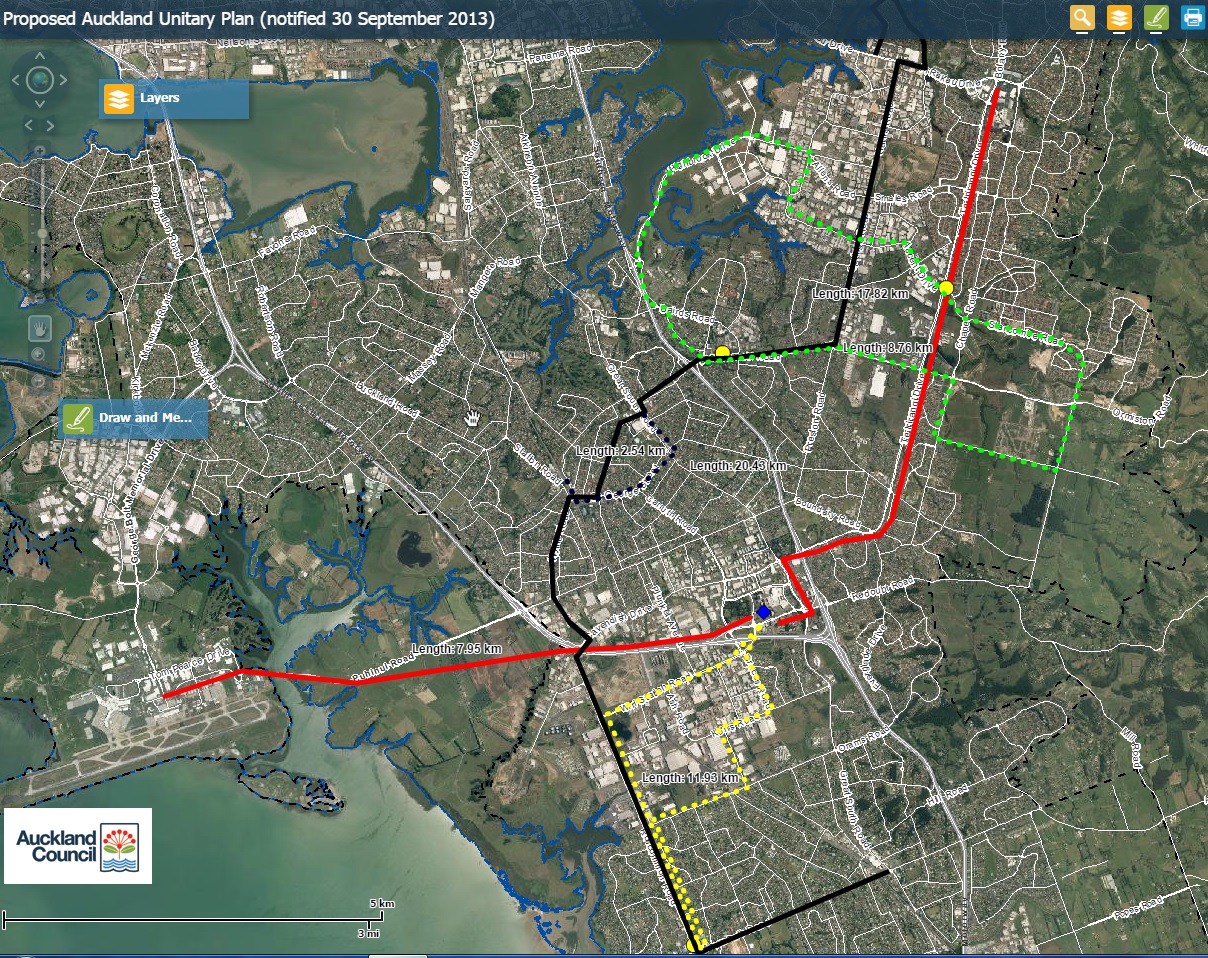
- Red: Future Panmure-Pakuranga-Botany-Manukau-Airport Sky Train.
- Black: East Tamaki – Otara – Papatoetoe – Wiri – Clendon – Manurewa “plugging the gap” cross city line.
- Yellow dots: Interchange points if using several buses to cover route (divided up) rather than a bus servicing the entire black line.
- Coloured Dash Lines: Population Centre to Industrial Complex “plugging the gap” 20 minute frequent line.
- Blue Diamond: Manukau City Centre Transport Interchange.
Ironically if the Weymouth-Karaka Bridge was ever built the Black Line would be easily extended through Weymouth and over the Bridge to Karaka allowing a direct mass transit line through the south west of Auckland. Remembering both Weymouth Road and Roscommon Road have wide medians or verges that were designed to take either rail, bus, or a widened road.
So something for the South and Auckland Transport to consider once the new network gets under way in filling those gaps.

