
Not the Corridor that bothers me, it is what they want in terms of Regional Development
The 4-lane de-facto urban motorway that is fast becoming the moniker for the Redoubt Road – Mill Road Corridor project illustrates we still have a VERY long way to go in achieving Mayor Len Brown’s “The World’s Most Liveable City.”
I should be clear though first up: it is not the corridor itself that bugs me as that road needs an upgrade, what bugs me is that do we need to gold plate the upgrade to and in effect motorway standards when the Southern Motorway is being upgraded and focus should be towards more pro-urban which includes better public and active transport links?
Also is the northern section of the entire corridor upgrade effectively repeating the same mistakes we have with the Southern Motorway where 7-lanes (South Western + Southern at Manukau Interchange) go down to two lanes within 1.5km after the dual motorway merge? The mistake being the 4-lane Mill Road upgrade going back to 2-lanes at the Alfriston School roundabout where the bulk of traffic actually continues south to Papakura itself. Something a commenter picked up on (as well as other things):
Great news for sure. EXCEPT for the reservations expressed, I share them. Serious lack of infrastructure even now and very little in the pipeline. Creating a passageway for Mill Rd and terminating it at Popes Rd does what? About the same as the compression of Southbound lanes between Manukau and Takanini. We need a visionary doing some future proofing. Let’s start by suggesting rapid light rail with buses feeding is a solution we are working on, lets extend it by increasing that capacity even further by literally elevating the rail system. That’s right, just like the Elevated in New York. Run bottom level for heavy freight, offer inducements to increase usage. Put light rail on top deck. Then there’s the wastewater reticulation system and all the others. Seriously, Auckland needs a smaller port with goods being transported in, NOT the other way. Growing Ports only exacerbates the problems we have.
…….
The Port one I will sit neutral on until the Future Port Study is completed in late 2016. But for the rest this is not the only time I have heard such remarks whether in part or full by others.
Buses feeding into the rail system (light or heavy) was something regular reader Bryce Pearce has mentioned to me and you can see below:
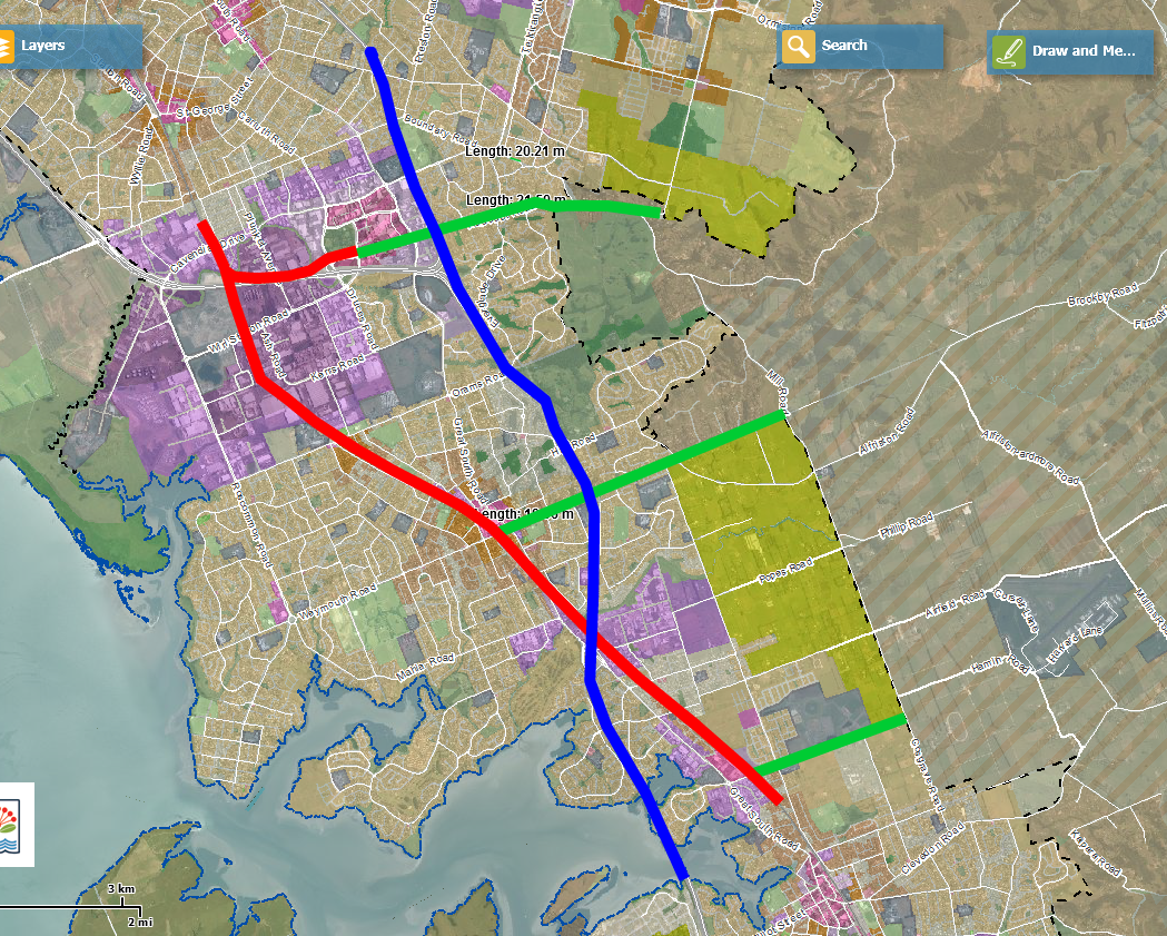
Blue = Southern Motorway
Green = Rapid Bus Links to a Rail Line
Red = Southern and Manukau Lines
Instead of going north/south along Mill Road and Redoubt with the buses to/from Manukau as I originally suggested, Bryce suggests buses goes east-west along:
- Redoubt Road to Manukau City Centre and Manukau Transport Interchange (being built soon)
- Along Ranfurly and Alfriston Roads to Manurewa Town Centre and Manurewa Transport Interchange
- Along Walters Road to the proposed Tironui Station which has come back on the cards.
The Walters Road east-west bus would supplement the Porchester Road bus in the New South Auckland Bus Network that eventually feeds into the Takanini Station
Of course I would still “back it up” by running a Mill Road north-south bus route to give the area and the Southern Line some redundancy capacity as well. Also it would assist in creating a school bus route to Alfriston School and the new Walters Road School.
My original idea being:
ALTERNATIVES (REDOUBT ROAD AND MILL ROAD (NORTH OF PAPAKURA))
Using the Street Mix web program (www.streetmix.net) I played around with some alternatives for the Redoubt Road section and Mill Road (so north of Papakura) section of the corridor upgrade using the existing corridor widths available.
This is what I came up with for the Redoubt Road section:
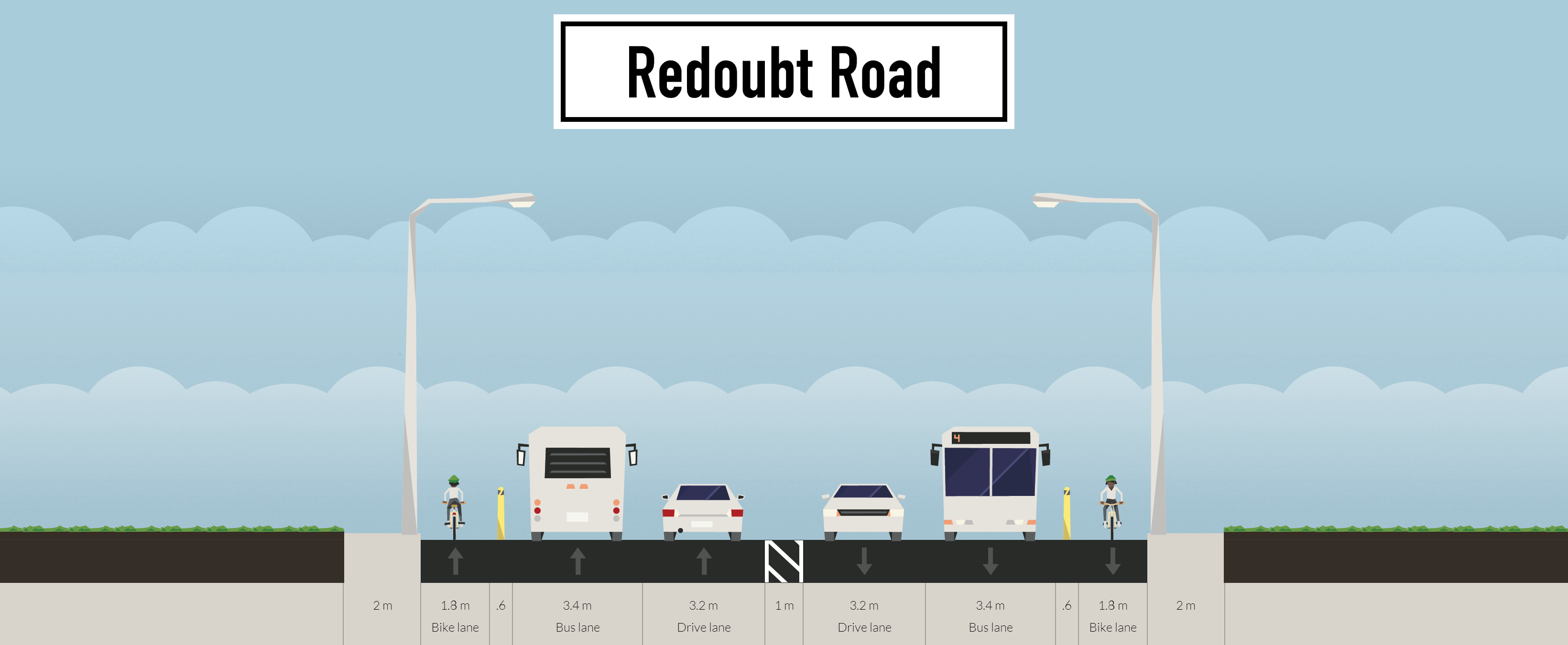
- No bicycles mixing with the bus traffic as in the AT design (so separated cycle lanes)
- 24 hour bus lanes in each direction to service frequencies per the new All Day Network coming up
- Bus lanes merge and mix with respective turning bays at intersections
- Proposed two metre foot paths remain
- When bus stop is present the bicycles would move to the footpath which would become a shared path. The cycle lane becomes a transit stop
- 2 lanes for general traffic
Mill Road (from Redoubt Road to Papakura)

As Mill Road becomes the Rural Urban Boundary once the Unitary Plan goes operative in 2016, and is flanked by the Future Urban Zone (rather than a live urban zone) it means development will not occur in that area straight away. This means to do a four lane road straight away would seem expensive and rather silly. However, we can do a transition phase where Mill Road is turned from a rural road (as it is now) into an urban road ready to be upgraded to its four lane maximum some time further down the track. The Mill Road transition piece would also allow the appalling safety record to be reversed. That record according to Auckland Transport being:
- There have been over 300 crashes along the Mill Road corridor between 2007-2011 resulting in five fatalities and 95 injuries
Once the Future Urban zones flip over into urban zones and begin urban development, the Mill Road transition phases upgrades to the full Mill Road corridor option. This would be staged and is in line with AT’s preferred building options for Mill Road:
- 2020 + Northern: Phased construction along Mill Rd corridor and Murphy’s Rd driven by growth
- 2020 + Southern: Construction dependent on growth
Rather than the 4 lane general traffic “sewer” I believe we can try for something more and truly multi-modal than what Auckland Transport is trying. Something a bit like these two alternatives:


Features:
- 2x general lanes
- 2x 24 hour 7 day a week bus lanes
- Parking Lane on the urban side (replaced with a bus stop as required)
- Separated cycle lanes
- 2 metre wide foot paths
- Option for planted median strip otherwise flush median would do fine
Yes I would have the bus lanes operating permanently owing to the future frequent buses that would use the upgraded Mill Road. And by frequent I mean at least every 15 minutes from 7am until 7pm every day of the week per AT’s South Auckland Bus Network plans. Where would the buses go? Three choices:
- Papakura to Botany via either Murphys Road or Hollyford Drive
- Papakura to Otara Town Centre via Hollyford Drive
- Papakura East to Manukau Transport Interchange via Mill Road and Redoubt Road
(rather than funnel everyone towards the Southern Rail Line (south of Manukau) and Great South Road corridors to go north)as adding redundancy capacity
Note: I have not worked on any alternatives for the Papakura to Drury section of Mill Road yet. I am waiting to see what Auckland Transport comes up with first in their own review before drawing up an alternative (if needed in the first place)
Note2: I am aware of Murphys Road being realigned which will take out several properties in the Murphys Road/Redoubt Road area and the issues that is causing. I also see Auckland Transport is due to lodge the Notice of Requirement for the northern section of the Mill Road Corridor. Again I await further public updates from AT. Will cover Murphys Road in a separate post.
……….
Source: https://voakl.net/2015/04/16/action-stations-south-auckland-needs-your-help-motorways-again/
To make either idea from both Bryce and myself work though it is dependent on one key link that is missing. The Manukau South Rail Link allowing Pukekohe and Papakura to Manukau train services direct with no cumbersome transfer at Puhinui. This is especially as (from another regular reader):
I’ve always said it is the most cost-effective infrastructure they could do, short and long-term. You’re a great fan of Manukau becoming 2nd CBD. It allows froth without putting pressure on other junctions, allows expansion of housing south, release land for housing all the way to Pukekohe with extra stations and electrification also becomes cost-effective
…..
This brings us to Regional Development
Regional Development
It seems Auckland Council and in part Auckland Transport have an issue in developing “The World’s Most Liveable City.” Granted the Unitary Plan is not live until next year but that does not stop preparations (like Area Plans) being made to achieve the primary goal of the Auckland Plan.
Yet I have questions that have me honestly perplexed with Auckland Council and Auckland Transport:
The World’s Most Liveable City =
- 4 lane defacto urban motorways/flyovers
- Painted cycle lanes
- Multi lane roundabouts
Am I missing something?
Part Two
Missing:
- South Links
- Bus Lanes
- Separated cycle paths
- Foot paths
- Removal of slip lanes
Am I missing something?
Part Three courtesy of a reader :
Missing:
- ALRT (Light Rail like Sky Train)
- Synchronized traffic lights
- 4-way stops
- Hi-density housing
- Urban villages
Am I Missing something?
Part Four (and final)
Missing:
- Parklets
- Master Plans
- Berm Gardens
- Public Transport
Actually not missing those, just needs to be built on
……..
So something is amiss with our regional development when we do get 4-lane defacto motorways and multi lane roundabouts but miss urban pieces like bus lanes, rail links, foot paths and decent villages that is not the Waterfront.
This applies especially to Southern Auckland with some 50,000 homes and 35,000 commercial AND industrial jobs on the way over the next 30 years. And those figures are an absolute minimum as well so expect more especially as we move from 38% to 45% of Auckland’s population and house all but one of the big heavy industrial complexes (Southdown-Onehunga).
To handle such growth the South (as well as Auckland) can not put up with these de-facto motorways and multi lane roundabouts while missing all the above urban features in Parts Two to Four. Not if we want to achieve both “The World’s Most Liveable City” (not the World’s biggest car park) and have a City that is or has a:
COMPETITIVE ECONOMY INCLUDING AN OUTSTANDING ONE NETWORK TRANSPORTATION SYSTEM
- MOVE TO OUTSTANDING PUBLIC TRANSPORT WITHIN ONE NETWORK
- SUBSTANTIALLY RAISE LIVING STANDARDS FOR ALL AUCKLANDERS AND FOCUS ON THOSE MOST IN NEED
PEOPLE AND PLACE INCLUDING MAORI AND YOUNG PEOPLE SOCIAL AND ECONOMIC WELL-BEING, AND HISTORIC HERITAGE
- SIGNIFICANTLY LIFT MĀORI SOCIAL AND ECONOMIC WELL-BEING
- DRAMATICALLY ACCELERATE THE PROSPECTS OF AUCKLAND’S CHILDREN AND YOUNG PEOPLE
THE NATURAL ENVIRONMENT INCLUDING THE RURAL URBAN BOUNDARY
- RADICALLY IMPROVE THE QUALITY OF URBAN LIVING
- STRONGLY COMMIT TO ENVIRONMENTAL ACTION AND GREEN GROWTH
HOUSING CHOICE INCLUDING MANAGING GREENFIELD SUPPLY, URBAN RENEWAL, AND HOUSING CHOICE THROUGH ALLOWING FREELY DIFFERENT HOUSING TYPOLOGIES (SO AFFORDABILITY)
- RADICALLY IMPROVE THE QUALITY OF URBAN LIVING
- SUBSTANTIALLY RAISE LIVING STANDARDS FOR ALL AUCKLANDERS AND FOCUS ON THOSE MOST IN NEED
………………..
Source: https://voakl.net/2015/03/11/the-auckland-plan-and-the-sydney-plan-2/
I have asked for a public input slot at the May Auckland Development Committee to cover the above. I will let you know whether I am granted that slot by the Deputy Mayor or not.
In any case as things stand with Mill Road and just recently Flat Bush we are not achieving the Mayor’s goal of “The World’s Most Liveable City.”

