
Let’s get the mindset as Planners right. Let’s also get those standardised zones match fit as well!
Submissions are open for the Planning Bill, and the Standardised Zones will soon be undergoing their drafting once the Ministry for the Environment has brought on planners to assist with that year long task.
But first we as Planners need to get our mindset match fit. We need to go from gatekeeper to enabler. While at the same time those standardised zones I have been going on about for the past year also need to be match fit to ENABLE a better Aotearoa!
Let’s take a look at this ~6:00 minute video on re-coding our cities and how this needs to be done for that better Aotearoa. Note: the video was produced using Notebook LM to summarise twelve of my blog posts covering the Planning reforms and produce this video.
Technical Summary of the influence in re-coding our cities in Aotearoa
For those wanting some more technical material to chew on, I got the AI to pull summary versions of the two key influences I would like to see into the Planning Act, the Standardised Zones, and the updated National Policy Statement – Urban Development (NPS-UD).
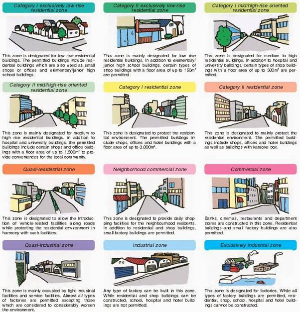
Identify the thirteen base land use zones used in Japan.
Based on the sources provided, Japan utilizes 13 base land use zones that serve as a standardized framework for building control, regulating both land use and building form. These zones are primarily applied within Urbanization Promoting Areas (UPA).
The thirteen zones are categorized into residential, commercial, and industrial districts as follows:
Residential Districts (8 Zones)
The Japanese system includes eight types of residential districts, ranging from low-density exclusive areas to more flexible zones that allow for some commercial activity.
- Category I low-rise exclusive residential zone: Strictly for low-rise housing; for example, hotels are prohibited here.
- Category II low-rise exclusive residential zone
- Category I mid-to-high-rise exclusive residential zone
- Category II mid-to-high-rise exclusive residential zone
- Category I residential zone
- Category II residential zone
- Quasi-residential zone
- Rural residential zone: A zone used for low-rise housing (up to 500 sq.m.) specifically related to the promotion of agriculture.
Commercial Districts (2 Zones)
These zones are designed to facilitate business and trade while managing their impact on the surrounding urban fabric. 9. Neighborhood commercial zone: Typically for shops providing daily necessities to local residents. 10. Commercial zone: For more intensive commercial activities and city-center functions.
Industrial Districts (3 Zones)
These zones manage the placement of manufacturing and industrial facilities. 11. Quasi-industrial zone: Allows for light industry and some non-industrial uses. 12. Industrial zone: For general industrial use. 13. Industrial exclusive zone: Strictly for industrial facilities where residential development is generally not permitted.
Regulatory Context
Each of these districts is governed by specific criteria related to the Building Standard Act, including building coverage, floor-space ratios, height limitations, and shadow area limitations. While these 13 zones provide the base framework, additional layers such as Overlays, Specialised Zones, and District Plans can be applied on top of them to address local geographic needs.
To visualize this, think of these 13 zones as a standardized set of LEGO bricks; while there are only a few types of bricks, the way they are combined and layered allows for the creation of diverse and complex urban environments.
Compare proposed Category 1 and Category 2 transport corridor intensifications.
Under the proposed planning reforms in Aotearoa, Category 1 and Category 2 key public transport corridors are designed to enable intensification in areas that are well-serviced by transit but do not meet the current strict definition of “rapid transit”. These categories provide a tiered approach to building height and density based on the strategic significance and service frequency of the corridor.
The following table and details compare the two proposed categories:
| Feature | Category 1 (Spine Corridors) | Category 2 (Primary Corridors) |
|---|---|---|
| Minimum Height | At least six storeys. | At least three storeys. |
| Network Classification | Defined as “spine” corridors under the NZTA One Network Framework. | Defined as “primary” corridors under the NZTA One Network Framework. |
| Service Frequency | Strategically significant with very high frequencies where multiple services merge. | Strategic corridors with frequent services operating most of the day, seven days a week. |
| Zoning Requirement | Councils must apply a standardized zone enabling higher density. | Councils must apply a standardized zone enabling medium density. |
Walkable Catchment Proposals
For both categories, the government is considering standardized intensification catchment sizes to prevent unnecessary debate over what constitutes a “walkable” distance. These distances would be measured “as walked” from the edge of the road reserve. Two options are currently under consideration:
- Option 1: A catchment size of 400 metres.
- Option 2: A catchment size of 600 metres.
Strategic Purpose
The distinction between these categories allows for a graduated transition of density. While Category 1 mirrors the intensity required around rapid transit stops (six storeys), Category 2 enables a more “gentle” density (three storeys) for corridors that are important but have slightly lower service levels. Local councils remain responsible for determining which specific corridors within their jurisdiction meet the criteria for each category.
To visualize this, you can think of Category 1 as the city’s major arteries, requiring high-capacity “flow” through tall buildings, while Category 2 represents the larger veins, supporting a steady but more moderate level of local activity.
This (AI generated) podcast goes into a deep dive about the reforms, and recoding our cities (as an outcome of the reforms

