
Where Planning Policy meets the end-user, aka YOU!
With my submission on the Planning Bill now with the Environment Select Committee, I am moving focus from Planning Theory to boots on the ground. Boots on the ground being designing and building our rural and urban areas using my version of the Aotearoa Planning Bill (see: My Submission to the New Zealand Planning Bill – 2026). While I have introduced our characters who will be the ambassadors for the Design-Led Placemaking series in this blog, we also need an introduction in the very thing that enables or disables it all: ZONES
As the Zones are the critical point where Policy Planning or rather Land Use Planning influences/dictates how Design-Led Placemaking would be done, we will take a look at the proposed Standardised Zones that would mentioned in my submission. These zones are adapted from the Japanese concept into the Aotearoa context. For example the Japanese version does not have rural zones, while the initial adapted Aotearoa version I drew up did not have “commercial” zones. Thus you will see what looks like two sweeps of my proposed zones as I had to add in the commercial zones. This post is video heavy as I will have all the videos concerning the Standardised Zones as of my submission.
I will also be bring back Marsden Point, and Manukau Ranges from Cities Skylines 2 as illustrative simulations of Design-Led Place Making.
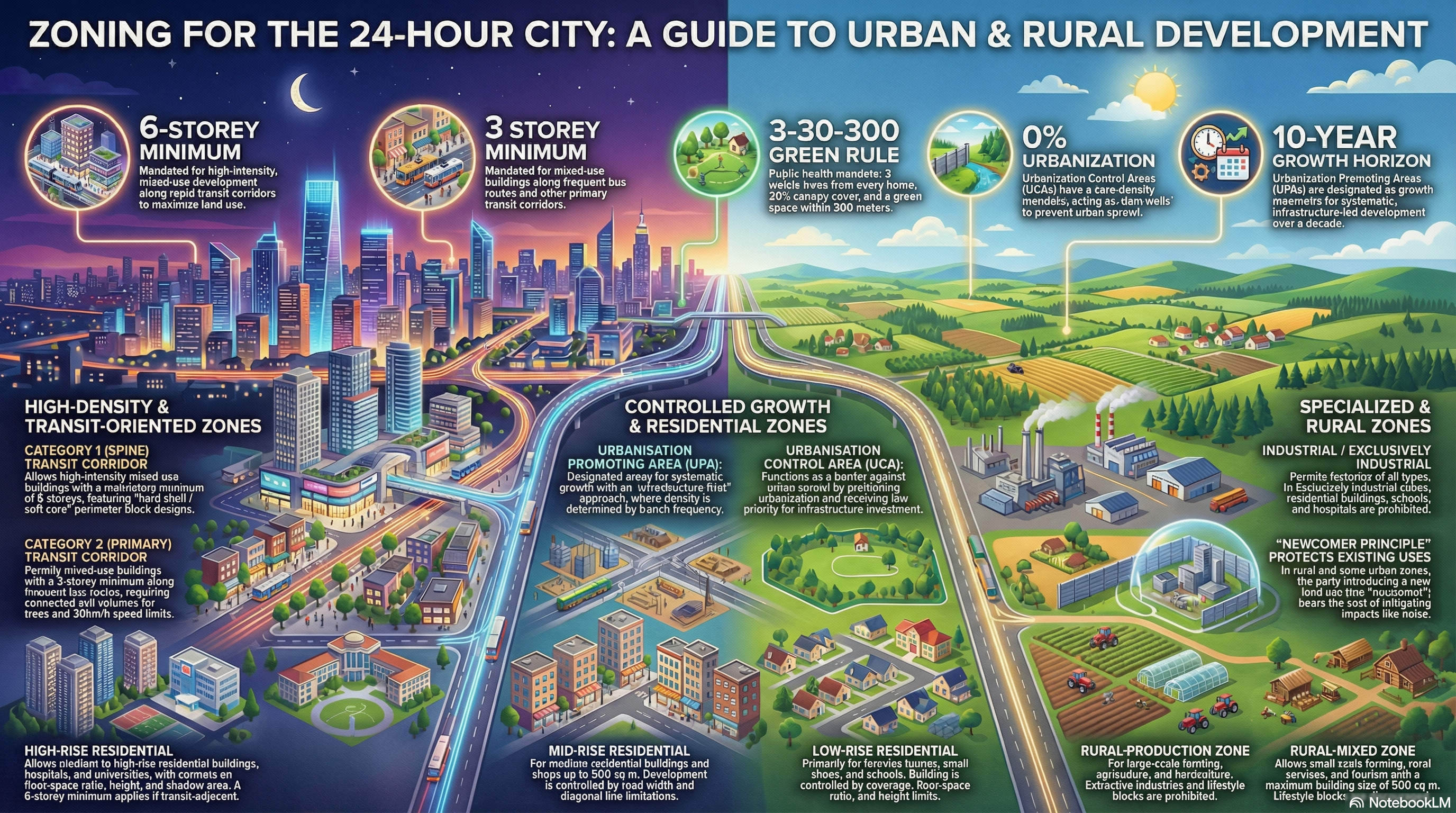
Those National Standardised Zones
Based on the Aotearoa Planning Bill 2025 and the associated implementation manuals, the following is an executive outline of the National Standardised Zones (NSZs).
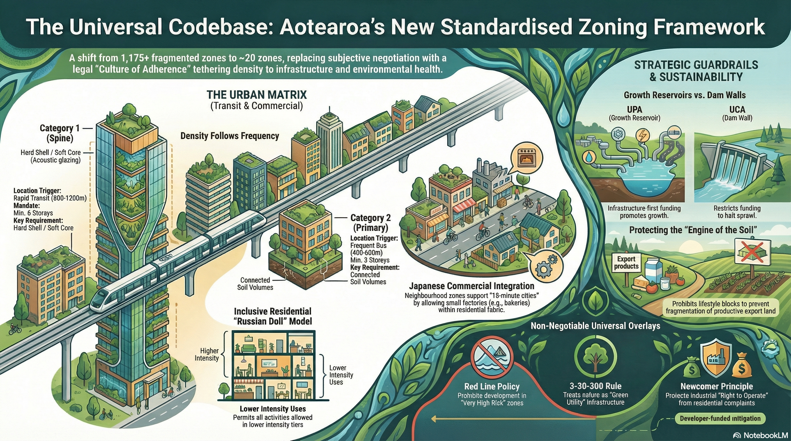
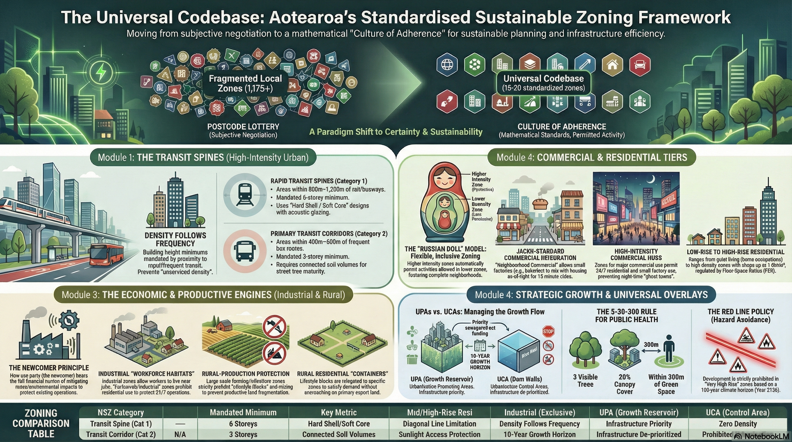
This framework replaces the legacy “Postcode Lottery” of 1,175+ fragmented local zones with a “Universal Codebase” of approximately 13–20 zones. For decision-makers, this shift moves the system from subjective negotiation to objective “Culture of Adherence”, where compliance with mathematical standards guarantees “Permitted Activity” status.
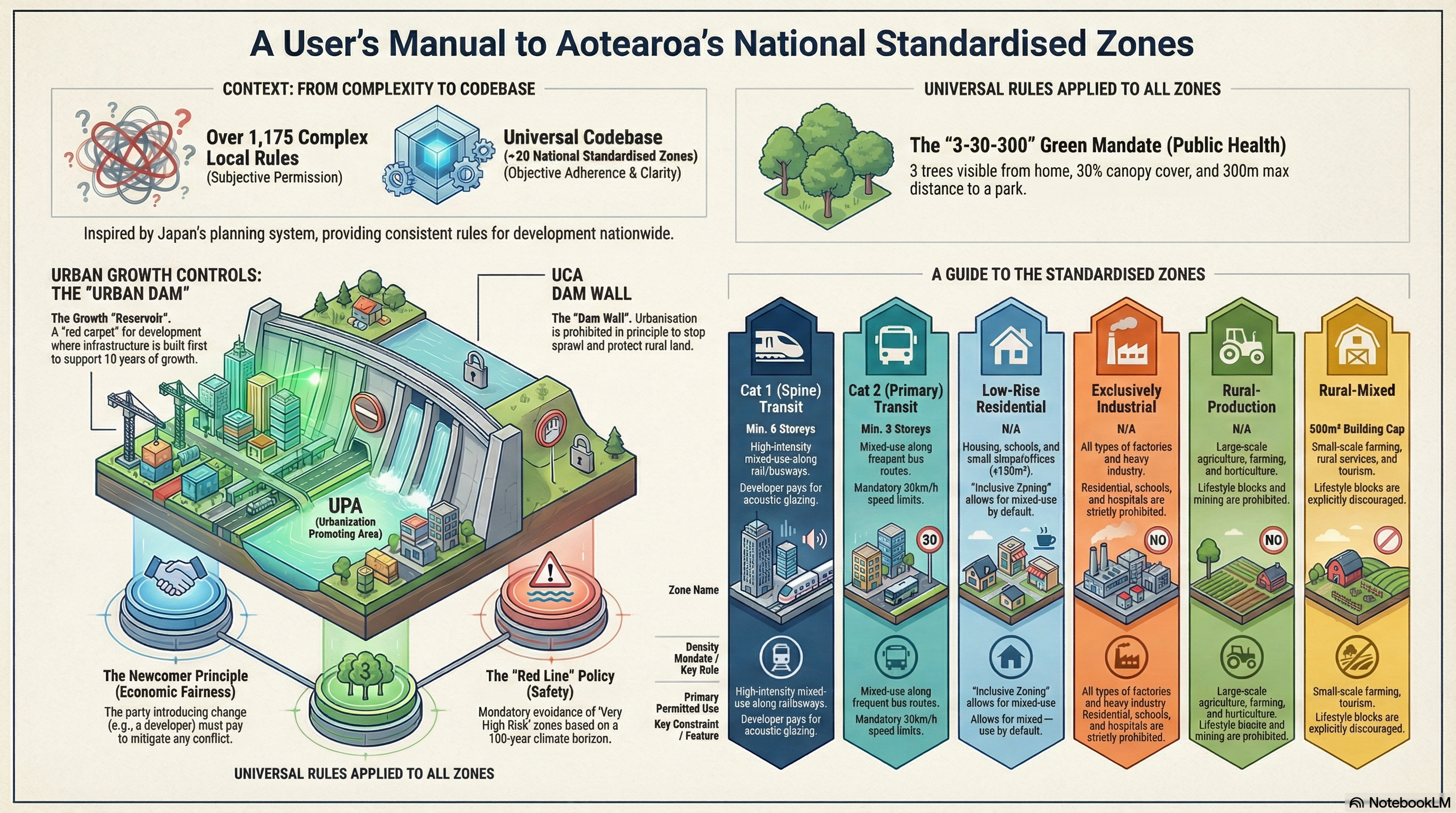
1. The Transit Spines (High-Intensity Urban)
Principle: “Density Follows Frequency.” Building height floors (minimums) are legally tethered to the capacity of the transport network.
Goal: To maximize the ROI on public infrastructure and prevent “unserviced density.”
| NSZ Name | Trigger Infrastructure | Mandate | Key Design Requirement |
| Category 1 (Spine) Transit Corridor | Rapid Transit (Rail, Light Rail, Busway) within 800m–1,200m. | Min. 6 Storeys | Hard Shell / Soft Core: Buildings must use acoustic glazing on the street-front to protect quiet inner courtyards. |
| Category 2 (Primary) Transit Corridor | Frequent Bus Routes within 400m–600m. | Min. 3 Storeys | Connected Soil Volumes: Engineering mandate for underground soil trenches to ensure street trees reach maturity. 30km/h speed limits. |
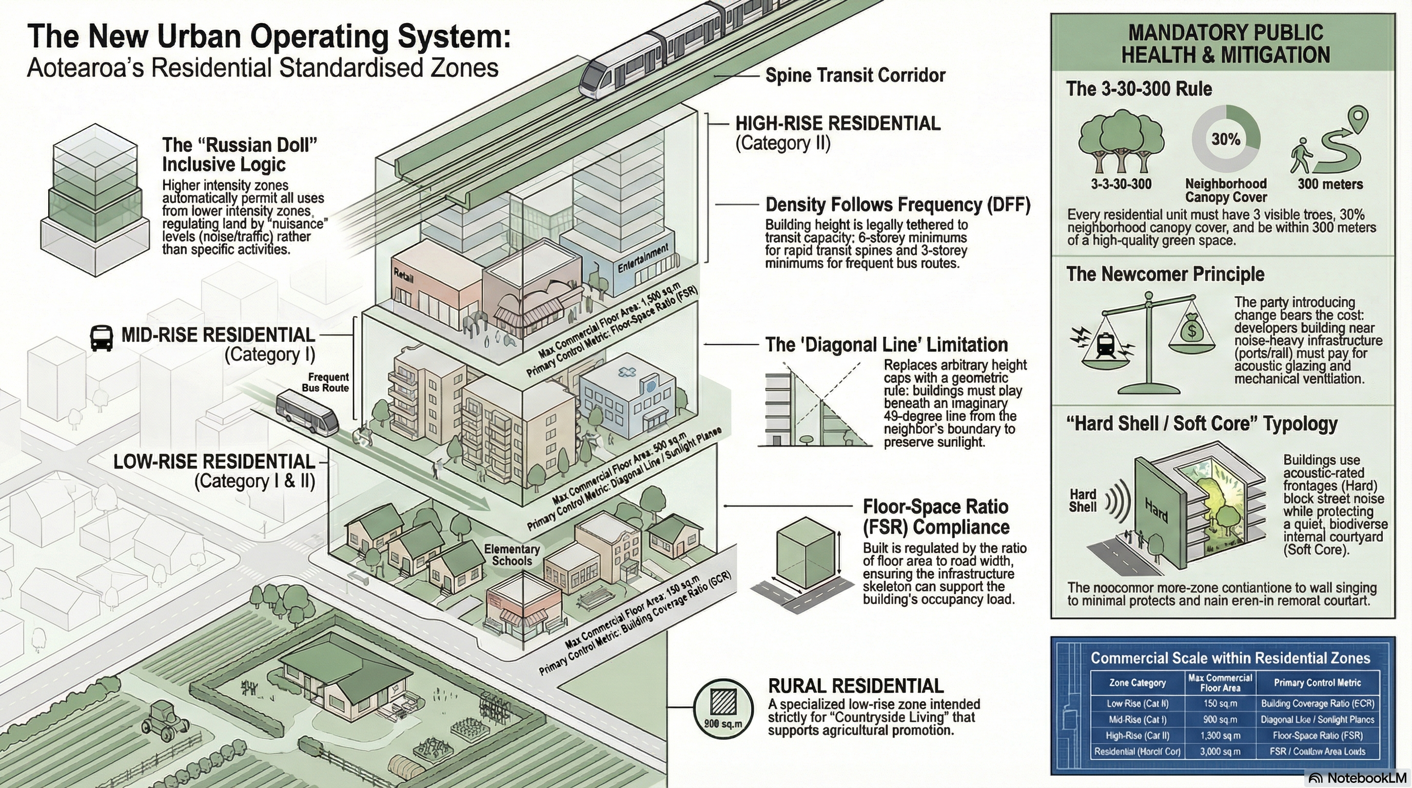
2. Residential Zones (The Inclusive Living Tiers)
Principle: “Inclusive Zoning” (Russian Doll Model). Higher intensity zones automatically permit activities allowed in lower zones.
Goal: To create “Complete Neighbourhoods” by permitting small-scale commerce “As-of-Right”.
| NSZ Name | Primary Use | Commercial Allowance | Control Mechanism |
| Low-Rise Residential (Cat I) | Quiet Living | Home occupations only. | Building Coverage Ratio (BCR) & Height Limits. |
| Low-Rise Residential (Cat II) | Complete Neighbourhoods | Up to 150m² As-of-Right: Dairies, cafes, and salons permitted on corner sites. | BCR & Height Limits. |
| Mid/High-Rise Residential (Cat I) | Density near Transit | Up to 500m²: Shops, hospitals, and universities permitted. | Diagonal Line Limitations: Ensures sunlight access to neighbours. |
| Mid/High-Rise Residential (Cat II) | High Density | Up to 1,500m²: Includes larger retail and entertainment. | Floor-Space Ratio (FSR): Regulates bulk relative to road width. |
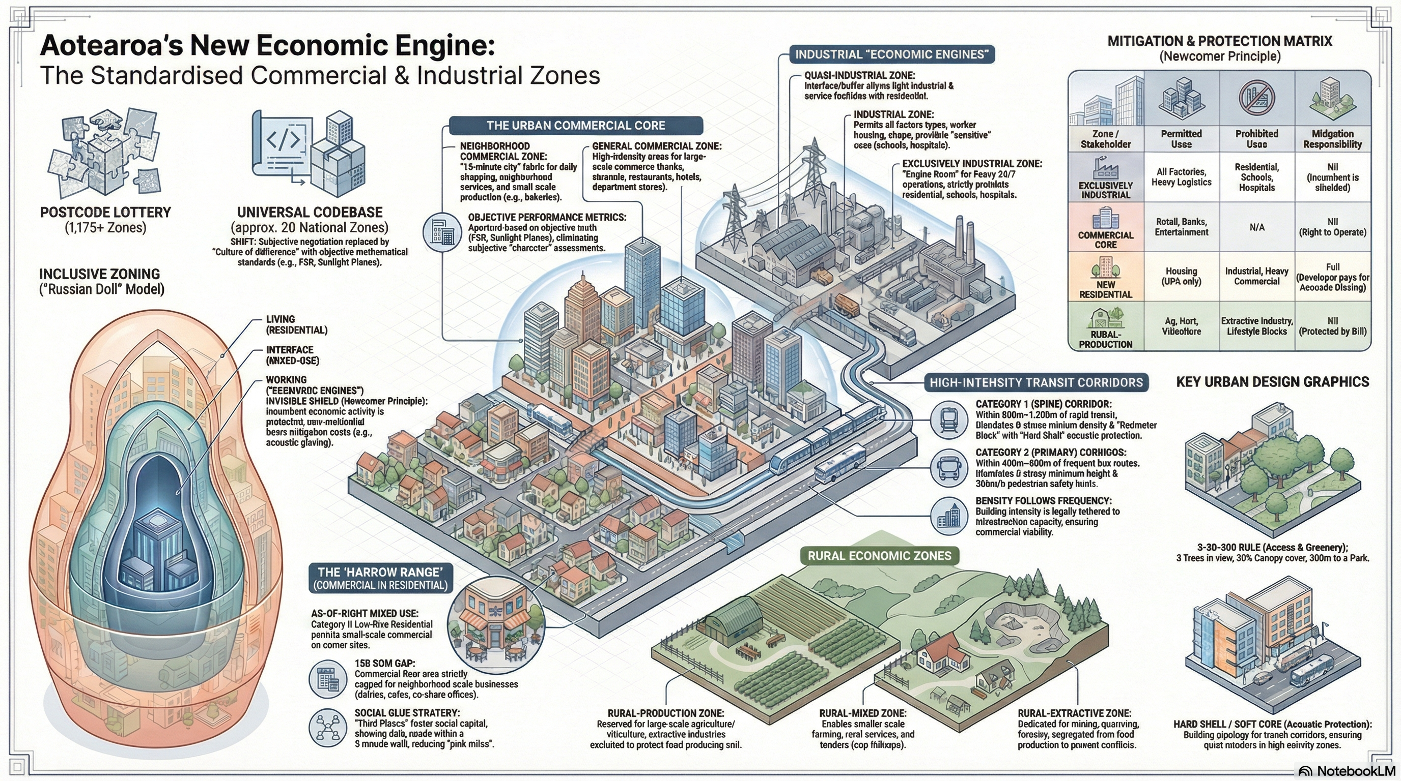
3. Industrial Zones (The Economic Engines)
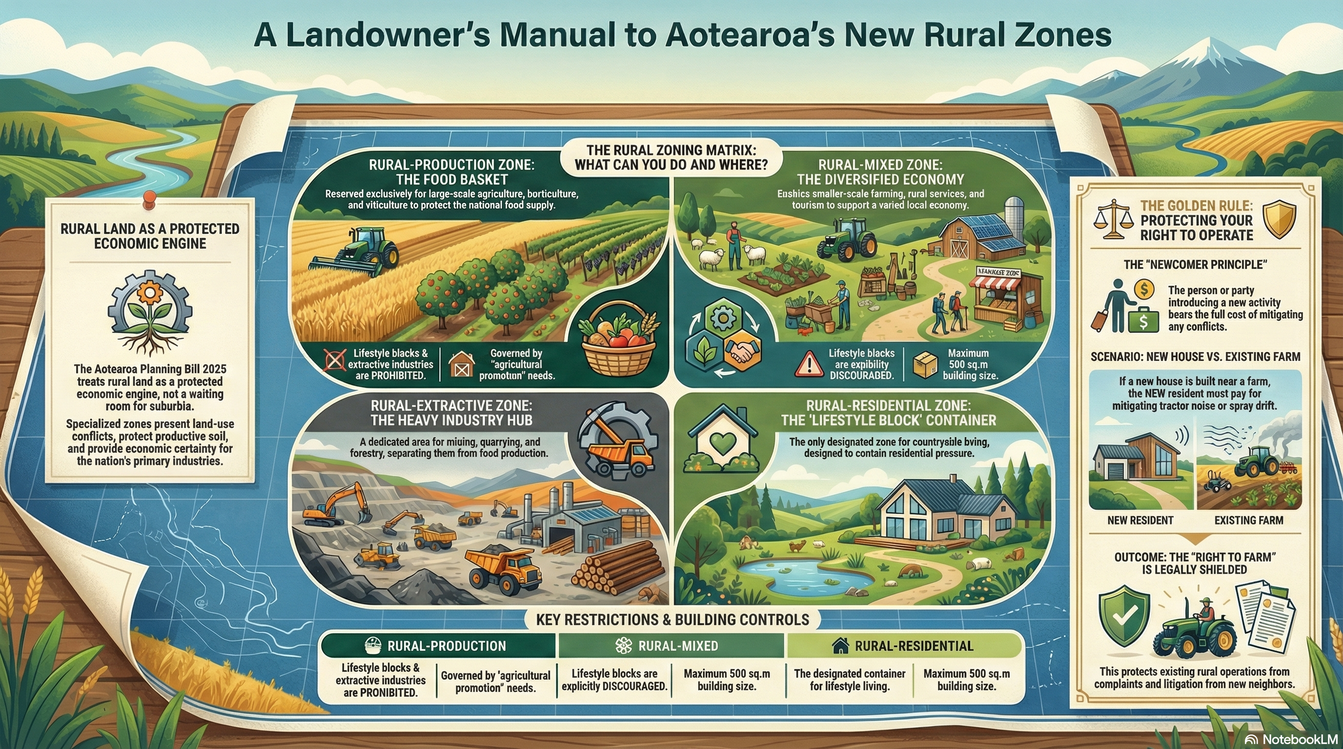
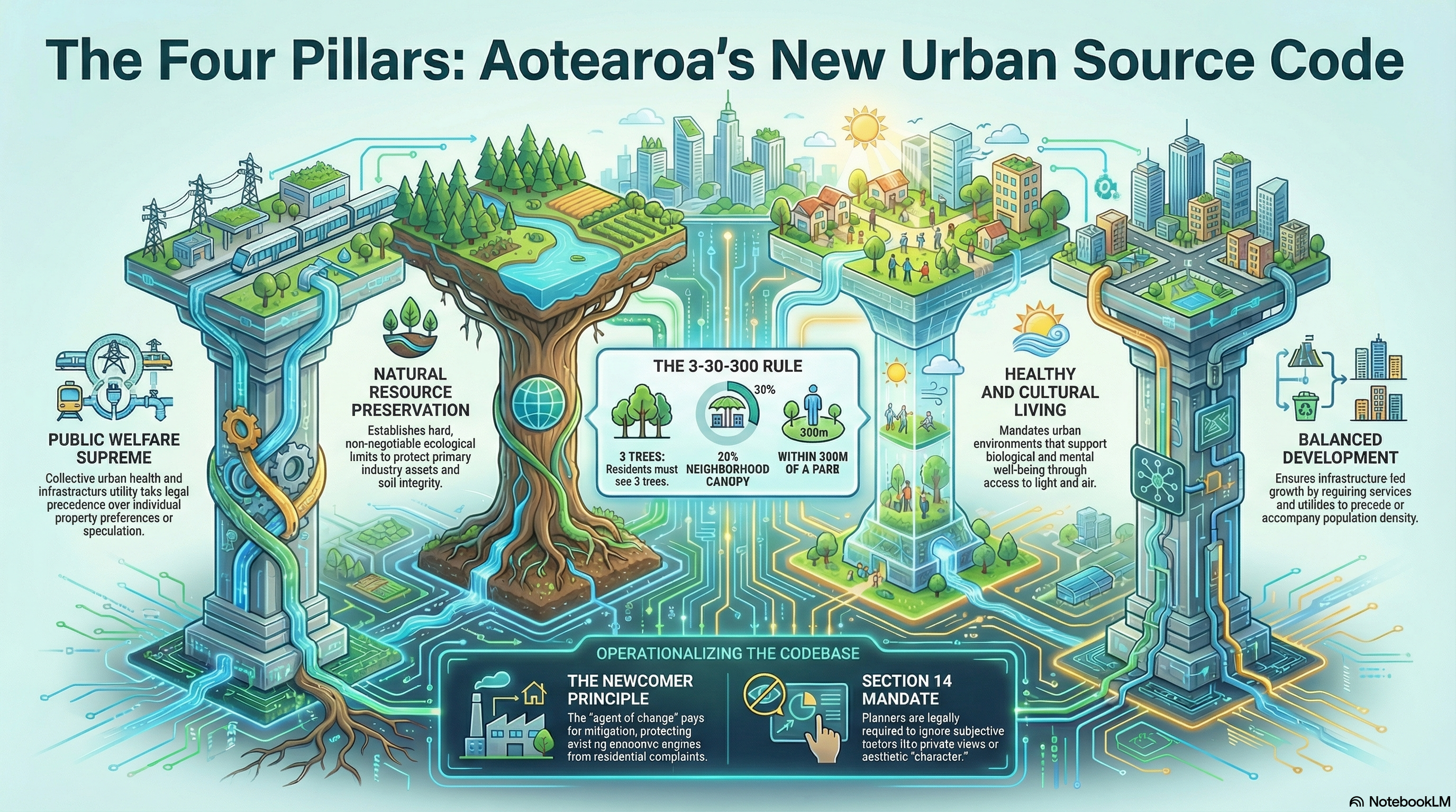
Principle: “Right to Operate.” These zones protect industry from “reverse sensitivity” (complaints from neighbours) using the Newcomer Principle.
Goal: To ensure 24/7 economic activity is not displaced by residential gentrification.
| NSZ Name | Permitted Uses | Strict Prohibitions | Strategic Function |
| Quasi-Industrial | Light industry, logistics, vehicle repair + Residential. | Heavy pollution. | Acts as a “Buffer Zone” between heavy industry and suburbs. |
| Industrial | All factories + Residential allowed. | Schools, Hospitals, Hotels. | Creates a “Workforce Habitat” where workers can live near jobs. |
| Exclusively Industrial | Heavy Industry, 24/7 Port/Rail operations. | Residential, Schools, Hospitals, Hotels. | The Engine Room: A “Hard Limit” that prevents housing to protect industrial noise rights. |
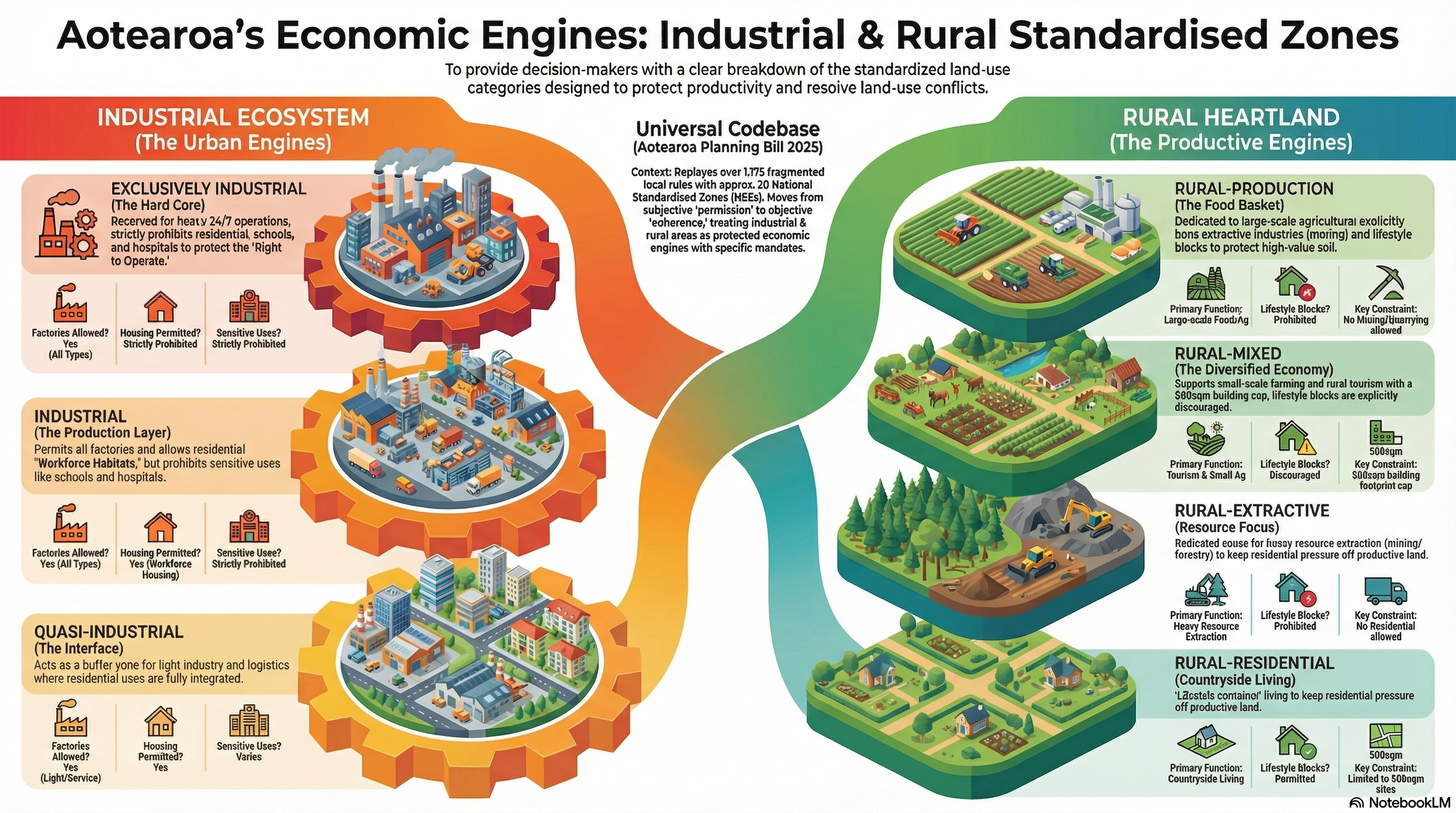
4. Rural Zones (The Productive Heartland)
Principle: “The Engine of the Soil.” Unlike the urban-centric Japanese model, these zones are adapted to protect New Zealand’s primary export economy.
Goal: To prevent the fragmentation of productive land by Lifestyle Blocks.
| NSZ Name | Primary Use | Lifestyle Blocks? | Key Constraint |
| Rural-Production | Large-scale farming, horticulture, viticulture. | PROHIBITED | No Mining: Extractive industries are banned to protect soil quality. |
| Rural-Mixed | Small-scale farming, tourism, rural services. | DISCOURAGED | Buildings capped at 500m² to prevent estate sprawl. |
| Rural-Extractive | Mining, Quarrying, Forestry. | NO | Uses overlays to segregate noise/dust from food production. |
| Rural Residential | “Countryside Living” | PERMITTED | The designated “container” for lifestyle living to save productive soil elsewhere. |
5. Commercial Zones
Goal: To service the residential fabric and city centres.
Neighbourhood Commercial: Small-scale factories (e.g., bakeries) and daily shopping need to support the “15-minute city” fabric.
Commercial: High-intensity zones for banks, cinemas, department stores, and hotels.
6. Universal Overlays (Non-Negotiable)
Regardless of the zone, decision-makers must enforce two cross-cutting mandates:
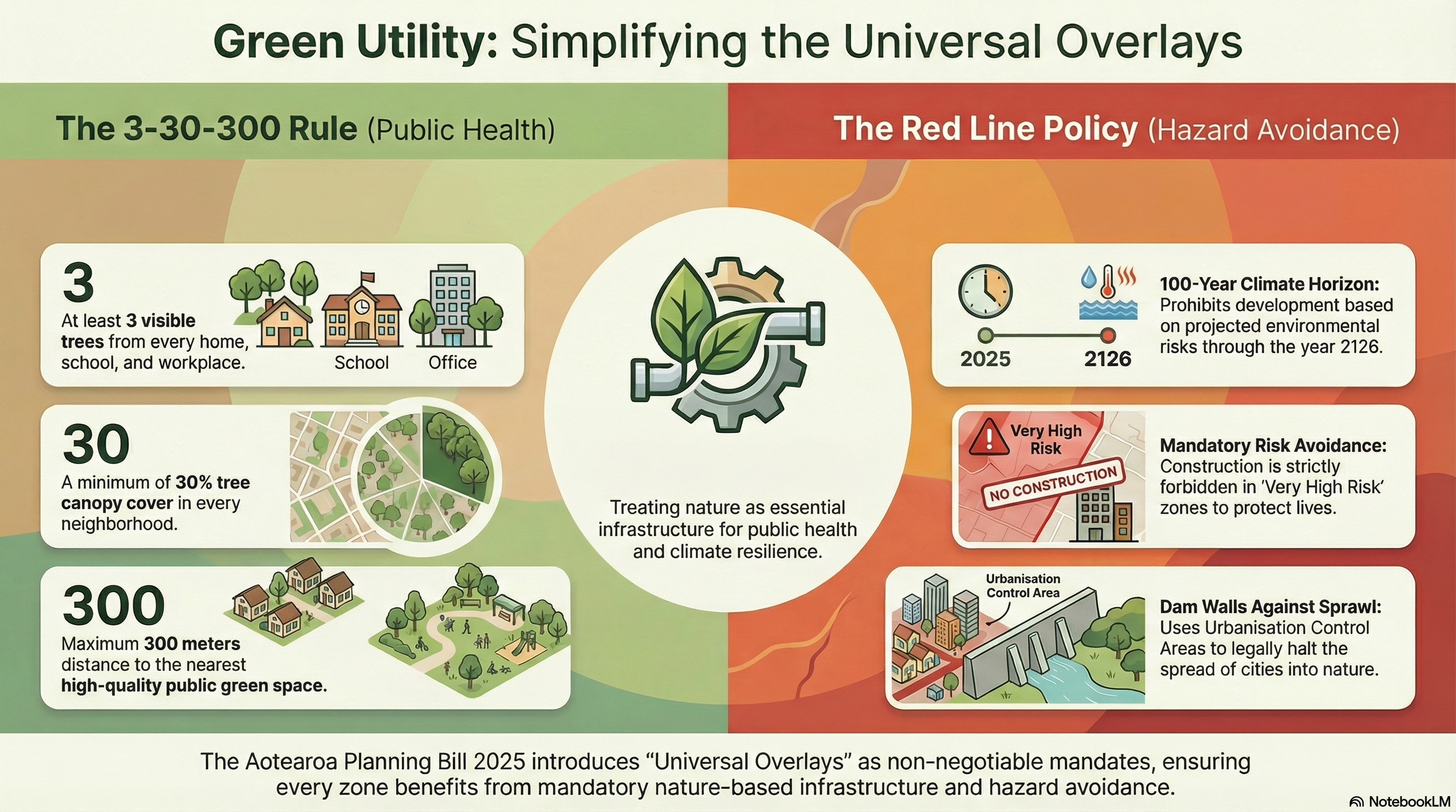
Public Health (The 3-30-300 Rule): Every zone (including industrial) must maintain 30% canopy cover and ensuring every occupant is within 300m of a green space. This treats nature as “Green Utility” infrastructure.
Hazard Avoidance (Red Line Policy): Development is prohibited in “Very High Risk” zones (Top-Left Risk Quadrant) based on a 100-year climate horizon (Year 2126).
This is a second sweep of the NSZ’s but with more context behind them especially the standalone commercial zones!
Based on the Aotearoa Planning Bill 2025 and the Master Japan and Aotearoa Zones Sheet, the following is an outline of the National Standardised Zones (NSZs). This framework replaces the fragmented “Postcode Lottery” with a “Universal Codebase” designed to move decision-making from subjective negotiation to a “Culture of Adherence”.
1. The Transit Spines (High-Intensity Urban)
Principle: “Density Follows Frequency.” Density minimums are legally tethered to transport capacity to prevent “unserviced density”.
- Category 1 (Spine) Transit Corridor:
- Location: Rapid Transit (Rail, Light Rail, Busway) within 800m–1,200m.
- Mandate: Minimum 6 Storeys.
- Key Requirement: Uses a “Hard Shell / Soft Core” typology, requiring acoustic glazing on street fronts to protect quiet inner courtyards.
- Category 2 (Primary) Transit Corridor:
- Location: Frequent Bus Routes within 400m–600m.
- Mandate: Minimum 3 Storeys.
- Key Requirement: Requires “Connected Soil Volumes” (underground trenches) to ensure street trees reach maturity, paired with 30km/h speed limits.
2. Commercial Zones (Japan Standard)
These zones are adapted directly from the Japanese model to service the residential fabric and city centres, integrating commercial and light industrial uses.
- Neighbourhood Commercial:
- Function: Supports the “15-minute city” fabric.
- Permitted Uses: Daily shopping, neighbourhood services, and small-scale factories (e.g., bakeries, tofu makers) are permitted to mix with housing.
- Commercial Zone:
- Function: High-intensity commercial hubs.
- Permitted Uses: Banks, cinemas, restaurants, department stores, and hotels. It also permits residential and small factory buildings, ensuring zones remain active 24/7 rather than becoming “ghost towns” at night.
- Quasi-Residential:
- Function: A zone designed for “harmony with vehicle-related facilities”.
- Permitted Uses: Large-scale residential allows coexistence with larger roads and automotive infrastructure, acting as a buffer between quiet residential and busier corridors.
3. Residential Zones (The Inclusive Living Tiers)
Principle: “Inclusive Zoning” (Russian Doll Model). Higher intensity zones automatically permit activities allowed in lower zones to create “Complete Neighbourhoods”.
- Low-Rise Residential (Cat I):
- Primary Use: Quiet living environments.
- Commercial: Restricted to home occupations only.
- Low-Rise Residential (Cat II):
- Primary Use: “Complete Neighbourhoods”.
- Commercial: Small-scale commercial (dairies, cafes, salons) up to 150 sq.m is permitted “As-of-Right” on corner sites.
- Mid/High-Rise Residential (Cat I):
- Primary Use: Medium density near transit.
- Commercial: Shops, hospitals, and universities permitted up to 500 sq.m.
- Control: Uses “Diagonal Line Limitations” to protect sunlight access for neighbours.
- Mid/High-Rise Residential (Cat II):
- Primary Use: High density.
- Commercial: Larger retail and entertainment permitted up to 1,500 sq.m.
- Control: Regulated by Floor-Space Ratio (FSR) relative to road width.
4. Industrial Zones (The Economic Engines)
Principle: “Right to Operate.” These zones prioritize economic activity, utilizing the Newcomer Principle to protect against reverse sensitivity (complaints from new residents).
- Quasi-Industrial: Acts as a “Buffer Zone” between heavy industry and suburbs. Light industry, logistics, and vehicle repair are permitted alongside residential use.
- Industrial: A “Workforce Habitat” where factories and residential uses coexist, allowing workers to live near jobs.
- Exclusively Industrial: The “Engine Room.” It permits heavy industry and 24/7 port/rail operations. To protect industrial noise rights, residential, schools, and hospitals are strictly prohibited.
5. Rural Zones (The Productive Heartland)
Principle: “The Engine of the Soil.” Unlike urban zones, these are designed to protect the primary export economy and prevent soil fragmentation.
- Rural-Production: Reserved for large-scale farming, horticulture, and viticulture. Lifestyle blocks are prohibited.
- Rural-Mixed: Focuses on small-scale farming and rural tourism. Lifestyle blocks are discouraged.
- Rural-Extractive: Dedicated to mining and forestry. Uses overlays to segregate noise and dust.
- Rural Residential: The designated “container” for countryside living (Lifestyle blocks). Housing is permitted here to save productive soil elsewhere, capped at 500 sq.m.
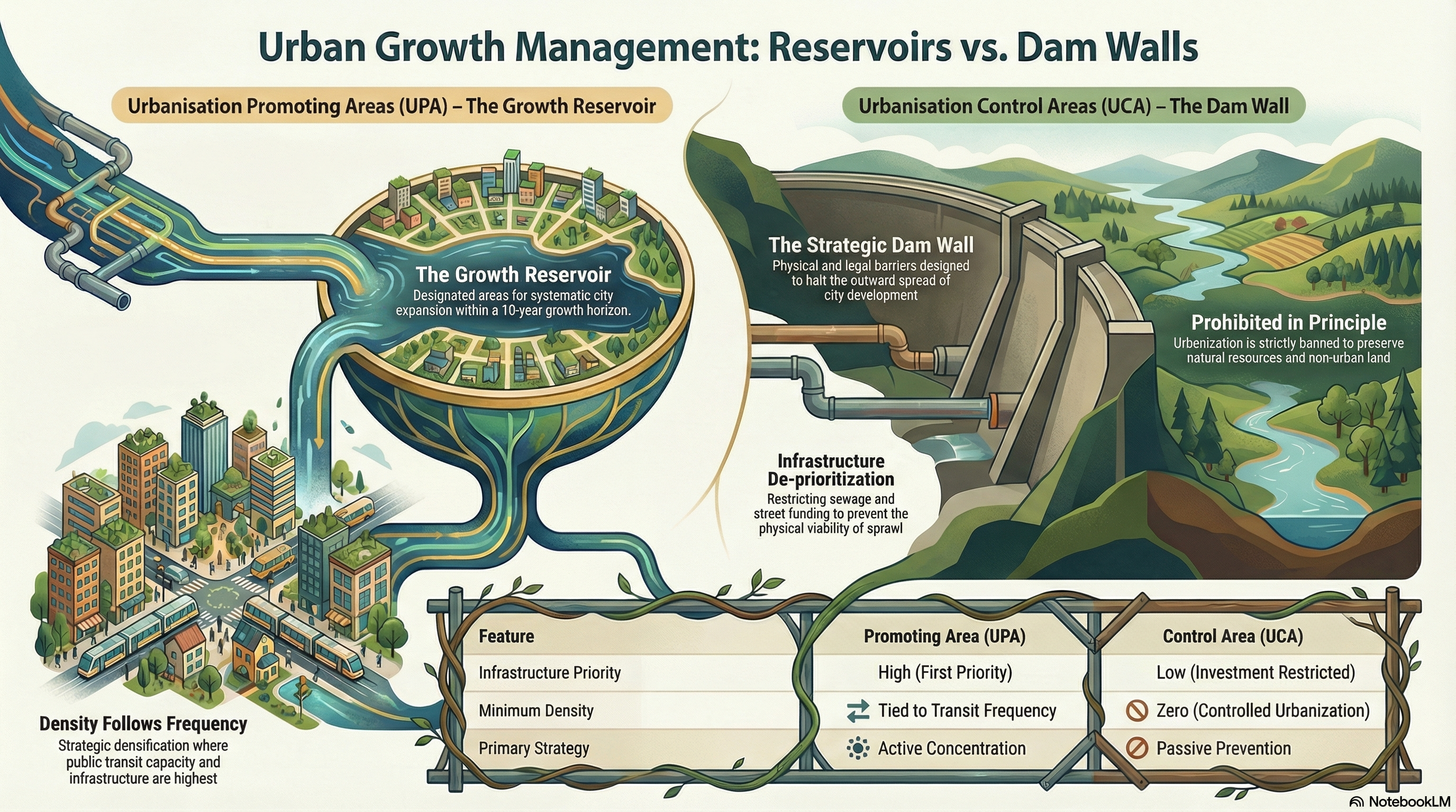
6. Strategic Growth Management
- Urbanisation Promoting Area (UPA): Designated “growth reservoirs” for systematic urbanization within a 10-year horizon. These areas receive “infrastructure-first prioritization” (sewage and streets).
- Urbanisation Control Area (UCA): Functions as “dam walls” against sprawl. Urbanization is prohibited in principle, backed by a low priority for infrastructure investment.

7. Universal Overlays (Non-Negotiable)
Regardless of the zone, decision-makers must enforce these cross-cutting mandates:
- Public Health (3-30-300 Rule): Every zone must maintain 3 visible trees, 30% canopy cover, and ensure occupants are within 300m of green space.
- Hazard Avoidance (Red Line Policy): Development is prohibited in “Very High Risk” zones based on a 100-year climate horizon (Year 2126).
Next post we will get into some “Project Management” using Design-Led Placemaking based in the Standardised Zones and the Aotearoa Planning Bill.

