
We have the Law, we have the National Spatial Plan, now for the Regional Spatial Plan
In the previous post we met; Maia, Tane, Alex, and Kahu. The four characters who will take us through their respective design-led placing project reflecting the principals of my submission to the Planning Bill (see: My Submission to the New Zealand Planning Bill – 2026). But before we can get to those projects, we need to do some spatial planning as outlined in the submission.
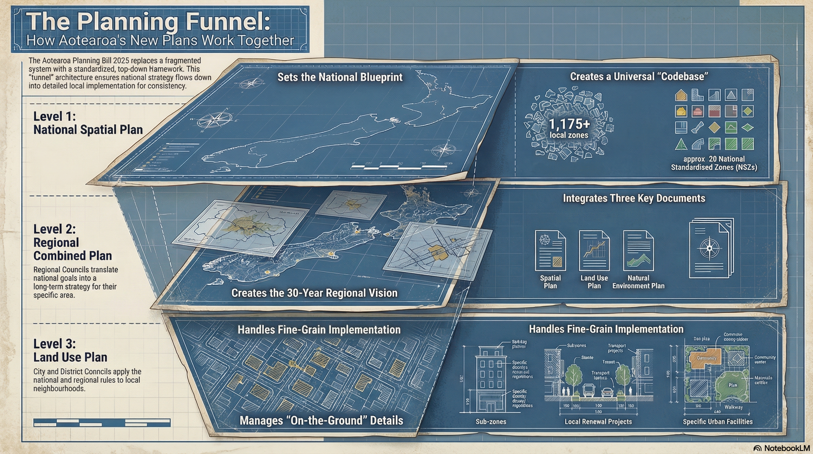
Strategic Portfolio: The 30-Year Regional Spatial Plan (2025–2055)
1. The Strategic Vision: Transitioning to the “Culture of Adherence”
The Aotearoa Planning Bill 2025 mandates a total liquidation of the era of subjective, character-based planning. We are formally transitioning to a mathematical “Culture of Adherence,” where the built environment is governed by objective metrics of density, frequency, and capacity rather than aesthetic opinion. This shift is the cornerstone of regional stability; by removing the friction of discretionary hearings, we provide the certainty required for high-stakes infrastructure investment. We are no longer designing “Dormitory Suburbs” for human storage; we are engineering “Complete Neighbourhoods” that function as high-performance, 24/7 ecosystems.
Core Strategic Pillars
- Abolition of the “Car Tax”: Eliminating the mandatory financial burden of vehicle ownership by engineering environments where every daily need is met within a 15-minute walk.
- The Linger Factor: Prioritizing pedestrian-centric design to capture the 66% increase in consumer spending associated with foot traffic over vehicle transit.
- Infrastructure-First Sequencing: Establishing the “Skeleton” (pipes, power, and transit) as a funded prerequisite to private “flesh” (construction).
- Mathematical Standardization: Replacing vague guidelines with the 15 DU/AC tipping point and the 3-30-300 environmental mandate to ensure commercial and biological viability.
This strategy systematically eliminates “negative productivity” and “junk miles”—the wasted hours and capital spent on unnecessary transit. By concentrating growth within pressurized urban cores, we protect the regional economic engine from the dilution of sprawl.
2. The “Urban Dam” Strategy: Defining UPA and UCA Boundaries
The “Urban Dam” is our primary fiscal and environmental tool for regional containment. It enforces a strict binary in land use to prevent the leakage of urban sprawl and ensure infrastructure efficiency.
| Feature | Urbanisation Promoting Area (UPA) | Urbanisation Control Area (UCA) |
| Definition | The “Reservoir” designated for active growth and high-density development. | The “Urban Dam” where urbanization is prohibited to protect rural production. |
| Infrastructure Guarantee | Government-guaranteed “Infrastructure First” funding and delivery. | Withholding the “subsidy of sprawl”; municipal infrastructure is de-prioritized. |
| Development Permissibility | High; encouraged through standardized inclusive zoning and transit mandates. | Prohibited in principle; subdivision is banned to prevent land fragmentation. |
| Strategic Purpose | To catalyze high-productivity urban ecosystems and TODs. | To ensure land remains priced for production (farming) rather than speculation. |
A critical component of this strategy is the “Fiscal Strike” policy within the UCA. By intentionally withholding municipal infrastructure, we remove the speculative land value that typically precedes subdivision. When land is no longer viewed as “future suburbia,” it remains priced for its actual productive output as a rural engine. This legal and fiscal boundary creates the necessary internal pressure for our “Density Follows Frequency” mandate to take effect.

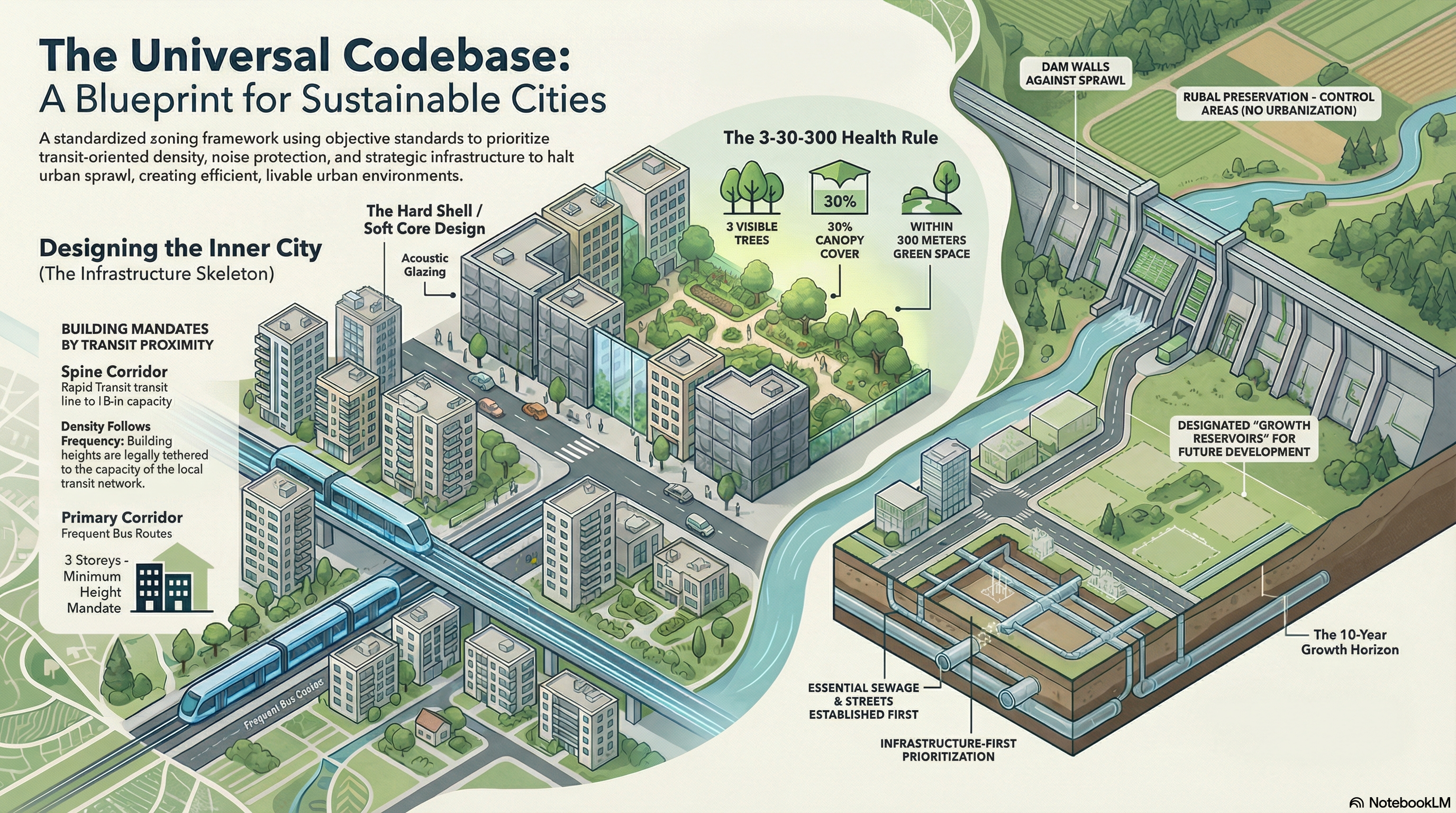
3. The “Infrastructure First” Mandate and Transit-Oriented Logic
Under the “Infrastructure First” principle, the regional skeleton must be fully operational before private construction begins. Building intensity is now legally tethered to the transit network via the “Density Follows Frequency” framework.
Zone A: The Transit Spine (Category 1)
- Proximity: 0–200m from Rapid Transit (Rail).
- Mandate: Minimum 6 storeys. Building below this capacity is an illegal waste of public transit investment.
- Typology: “Hard Shell / Soft Core” Perimeter Blocks. The street-facing “Hard Shell” acts as a mandatory acoustic shield, enabling the transport network to operate 24/7 without risk of noise litigation. The “Soft Core” provides a quiet, green internal sanctuary for residents.
Zone B: The Primary Corridor (Category 2)
- Proximity: 200–400m from Frequent Bus Routes.
- Mandate: Minimum 3 storeys.
- Street Design: Engineered for 30km/h limits to prioritize safety and the “Linger Factor.”
To achieve the 15 DU/AC (Dwelling Units Per Acre) tipping point required for transit and commercial viability, we deploy “Missing Middle” typologies: Cottage Courts, Stacked Duplexes, and Live-Work Units. Furthermore, we mandate “Surgical Connectivity” to un-break the grid, inserting trail connections between cul-de-sacs to convert 2-mile drives into 5-minute walks.
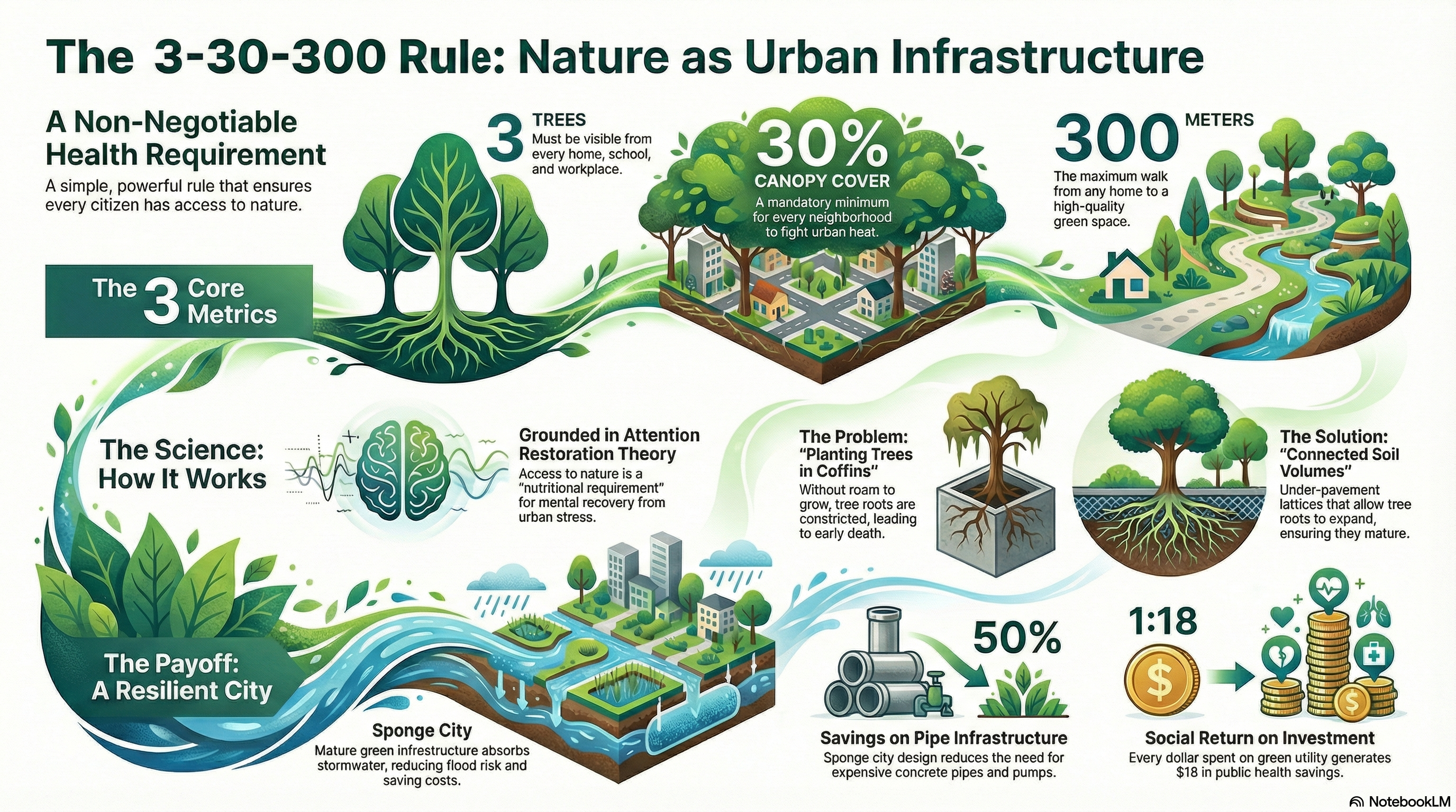
4. The “Green Utility”: Nature as Essential Biological Infrastructure
In the 30-year plan, nature is not an ornamental luxury; it is “Green Utility”—essential biological infrastructure. This utility provides a Triple ROI: a 1:3 return on tree maintenance versus grey infrastructure, a 1:18 return in public health savings, and a 50% CAPEX saving on stormwater management via “Sponge City” engineering.
The 3-30-300 Rule
- 3 Trees: Every home, school, and workplace must have a direct view of at least 3 mature trees to facilitate mental restoration (Attention Restoration Theory).
- 30% Canopy: Mandatory neighborhood-wide canopy cover to liquidate the “Urban Heat Island” effect.
- 300 Meters: Every resident must be within a 300-meter barrier-free walk of a high-quality park (min. 0.5 hectares), measured by the actual pedestrian path rather than a straight line.
To ensure tree maturity, we mandate “Connected Soil Volumes”—continuous underground trenches that prevent the “potted plant effect” of concrete coffins. This biological mandate is reinforced by the “Red Line Policy,” which prohibits development in the “Top-Left Risk Quadrant” (High Likelihood + Catastrophic Consequence) based on a 100-year climate horizon (to 2126).
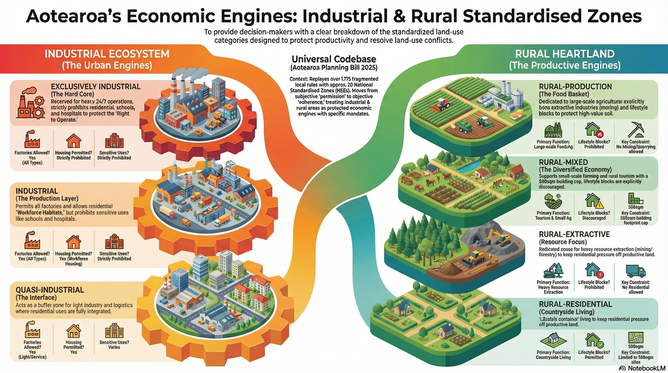
5. Operationalizing the Industrial and Rural Ecosystems
We protect the “Right to Operate” for heavy industry and primary production through effects-based segregation. Rural land is not a “waiting room” for housing; it is an Economic Engine operating at “Midday” productivity.
The Industrial Zoning Gradient
- Core (The Engine Room): Exclusively industrial. Heavy 24/7 operations are protected by an “Invisible Shield” that strictly prohibits schools, hospitals, and residential uses.
- Production: General manufacturing. Workforce housing is permitted to reduce commutes, but schools and hospitals remain prohibited to prevent reverse sensitivity.
- Interface: Light logistics and live-work units acting as a buffer to the residential city.
The Rural Zoning Matrix
- Rural-Production: Exclusively for large-scale food production. Lifestyle blocks are prohibited.
- Rural-Residential: A designated “Quarantine Zone” for lifestyle living. Building coverage is capped at 500sqm and must be strictly related to agricultural promotion to prevent suburban creep.
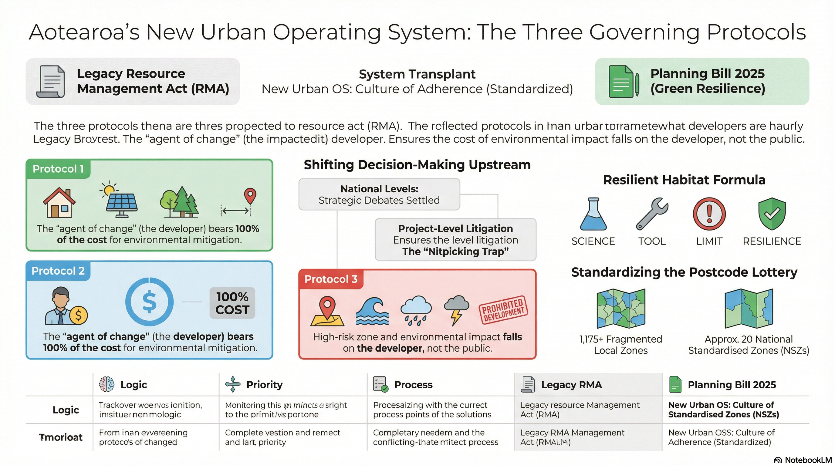
6. Implementation Mechanisms: The Newcomer Principle and Council Role
The legal foundation of the 2025 Bill shifts the burden from the “right to complain” to the “duty to mitigate” through the Newcomer Principle (Agent of Change). The party introducing a new sensitive use—such as a developer building apartments next to a rail line—is 100% responsible for funding acoustic glazing and mechanical ventilation.
Under the Section 14 Mandate, Councils are legally required to ignore subjective matters: neighbor views, aesthetic “character,” and the social status of future residents. The Council’s role is bifurcated:
- The DNA: Standardized, mathematical national codes governing private lots.
- The Spirit: “Design-Led Placemaking” of the public realm (streets, parks, and squares).
Councils will utilize Promotion Area Zones and Scheduling Areas—following the Transform Manukau (Eke Panuku) blueprint—to freeze land speculation and catalyze private investment by transforming “seas of parking into oceans of communities.” The outcome is a pressurized, productive, and resilient regional ecosystem for the next 30 years.
Now on to the design-led place making projects

