
Recapping the Urban Planning Operating System to support Design-Led Placemaking
Last one before we dive into our design-led placemaking projects lets take one last recap. This recap being on the urban principles that would be enabled if my Planning Submission was reality (My Submission to the New Zealand Planning Bill – 2026) and we followed a Design-led Placemaking Approach under the Public Welfare Supreme practice.
1. Introduction: From “Character” to the “Urban Operating System”
For decades, urban development in Aotearoa was paralyzed by a “Culture of Permission” rooted in subjective “character assessments.” This legacy system allowed aesthetic opinions and neighbour objections to create high levels of uncertainty, resulting in “Dormitory Suburbs”—low-productivity zones that function merely as storage for people and cars.
The Aotearoa Planning Bill mandates a total liquidation of this approach, replaced by a mathematical Urban Operating System (Urban OS). This system functions on a “Culture of Adherence”: if a design fits within the objective 3D “Legal Envelope,” permission is a guaranteed “Permitted Activity.” Under Section 14, planners are relieved of the duty to micromanage private aesthetics—such as window styles or paint colours—and are instead empowered to lead “Design-Led Placemaking” of the public realm.
The Paradigm Shift: Standardized Codebase vs. Postcode Lottery
| Legacy System (Subjective) | Urban Operating System (Objective) |
| Character Assessments: Decisions based on aesthetic whims. | Math-Based Adherence: Decisions governed by FSR, Sunlight Planes, and Diagonal Line Limitations. |
| Notification & Hearings: Public objections create “administrative debt” and risk. | Permission via Capacity: Intensity is legally tethered to transit frequency and infrastructure capacity. |
| Dormitory Suburbs: Segregated, car-dependent “storage for people.” | 24/7 Ecosystems: Integrated “Complete Neighbourhoods” where daily needs are walking distance. |
| Postcode Lottery: 1,175+ fragmented local zones. | Universal Codebase: ~20 National Standardised Zones (NSZ). |
Key Insight for the Student: The “So What?” is legal certainty. By prioritizing “Public Welfare Supreme,” the Urban OS uses the Russian Doll Model (Inclusive Zoning), where higher-intensity zones automatically permit all activities allowed in lower-intensity ones. This eliminates “Junk Miles”—wasted hours in traffic—and replaces them with productivity and quality of life.
This objective framework begins with the city’s high-capacity skeleton: the Transit Spine.
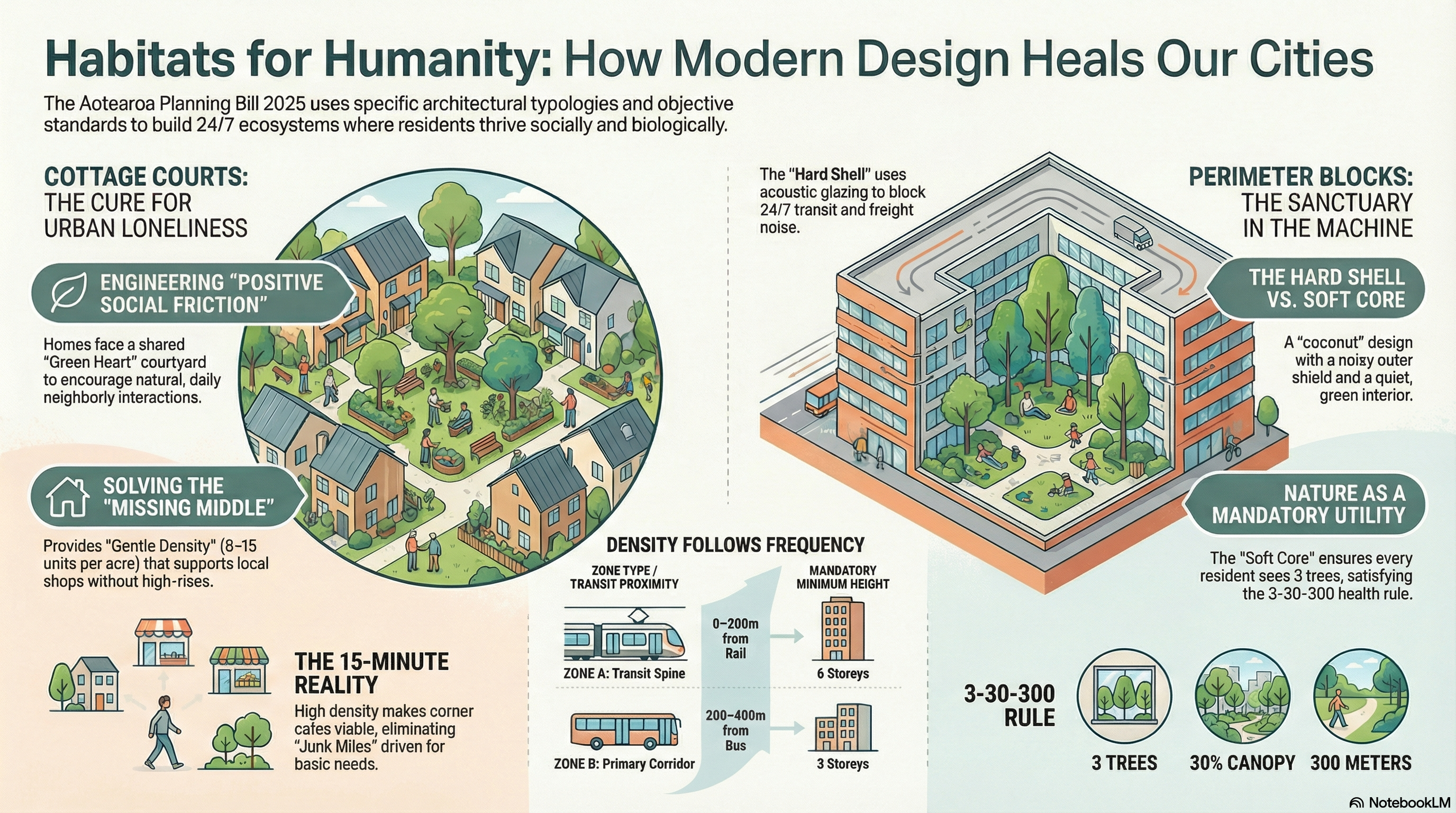
2. Typology 1: The Transit Spine (The Urban Skeleton)
The Transit Spine represents the highest intensity of the Urban OS, governed by the mandate: “Density Follows Frequency.” The primary model is the Airport to Botany (A2B) project, an 18km congestion-free corridor. In this system, we no longer zone for height based on sentiment; we zone for capacity to maximize the ROI on public infrastructure.
Strategic Design Features
- Category 1 Mandate (Spine): Applied within 800m–1,200m radii of Rapid Transit (Rail/Busway). It mandates a Minimum 6-storey height floor.
- Category 2 Mandate (Primary): Applied within 400m–600m of frequent bus routes, mandating a Minimum 3-storey height floor.
- The Boulevard Transformation: Modelled on Ronwood Avenue, this converts “seas of parking into oceans of communities,” integrating transit-ways with active mode paths.
To enable a vibrant 24/7 ecosystem, the Urban OS uses the “Agent of Change” rule to manage noise risk.
- Hard Shell / Soft Core: Buildings must act as a “Hard Shell”—using acoustic glazing and mechanical ventilation on street-fronts to shield a quiet, biodiverse “Soft Core” (internal courtyard).
- Right to Operate: The developer (the “Newcomer”) pays for mitigation. This protects the transit network’s right to run 24/7, ensuring residents sleep in silence while the economic engine remains active.
These high-intensity spines act as the pressurized anchors for the surrounding “Gentle Density” residential areas.
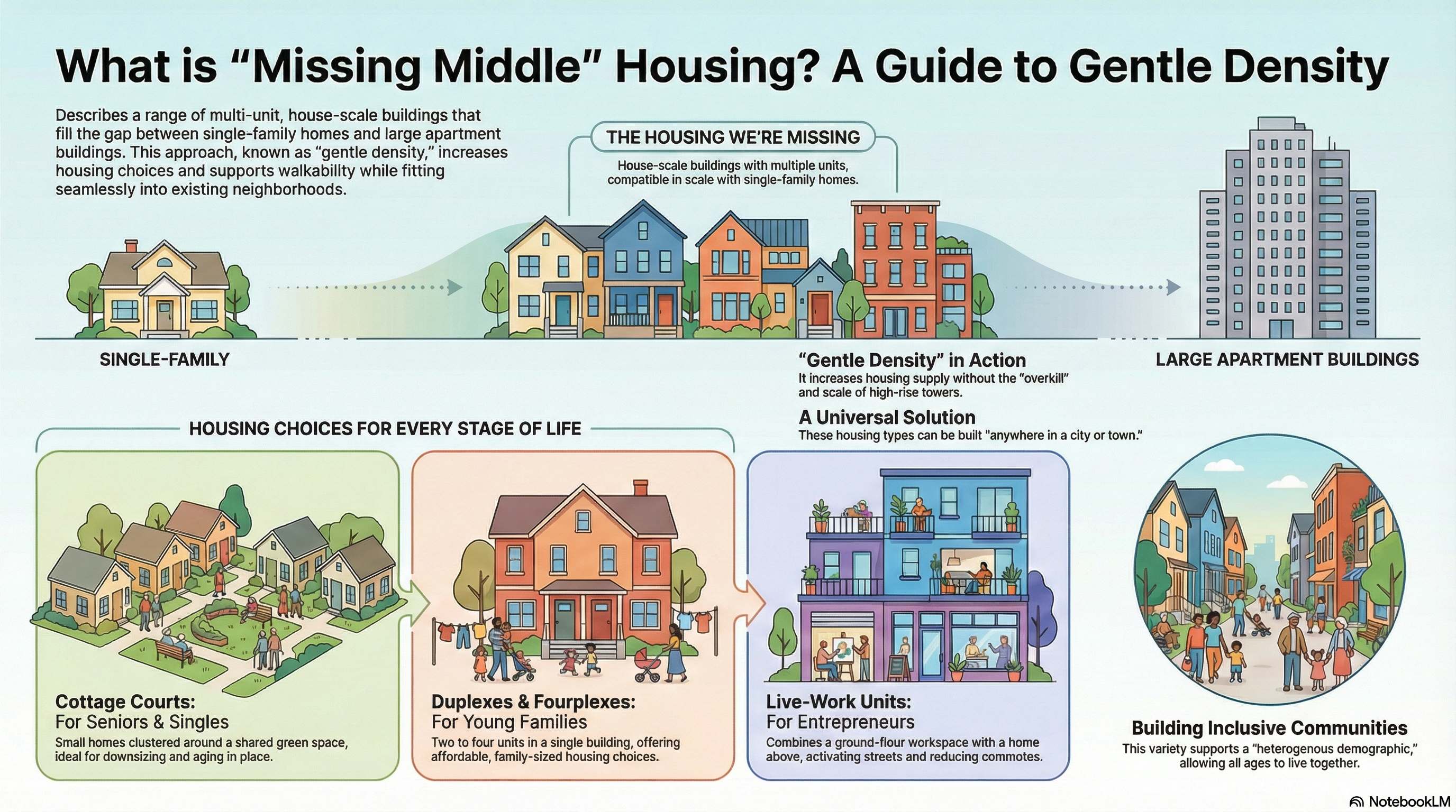
3. Typology 2: Resilient Suburbs (The Missing Middle)
Beyond the spine, the city transitions into the “Goldilocks Zone” of 8–15 Dwelling Units Per Acre (DU/AC). This is the mathematical tipping point required to make local commerce—cafes, dairies, and co-share offices—financially viable without car dependency.
The Missing Middle Housing Spectrum
| Typology Name | Physical Form | Primary Social/Economic Benefit |
| Cottage Courts | Small detached homes facing a shared “Green Heart.” | Antidote to loneliness; engineers “positive social friction” through neighbourly interaction. |
| Stacked Duplexes | Two units on one footprint; seniors on ground level. | Provides “Invisible Density” and supports “Aging in Place” for an aging population. |
| Live-Work Units | Row houses with ground-floor retail/office and residence above. | Zero-overhead incubator for micro-entrepreneurs; activates the “Daytime Economy.” |
Surgical Connectivity: Un-Breaking the Grid
To transform suburban navigation, the Urban OS implements a three-step logic to repair the legacy of cul-de-sacs:
- Identify Dead Ends: Locate blocks creating “Artificial Distance.”
- Insert Trail Connections: Cut pedestrian and cycle shortcuts through blocks.
- The 8-80 Rule: Ensure the grid is navigable by an 8-year-old on a bike or an 80-year-old in a wheelchair, converting 2-mile drives into 5-minute walks.
These walkable living areas are supported by zones of production, kept close enough to reduce commutes but managed via an effects-based gradient.
4. Typology 3: Industrial Ecosystems (The Engine Rooms)
The Urban OS replaces “Activity-Based Segregation” with an “Effects-Based Gradient.” This ensures the region’s industrial engine is protected from residential encroachment while allowing workers to live near their jobs.
- Tier 1: The Core (Engine Room): Exclusively Industrial. To protect the Right to Operate, residential uses and “sensitive uses”—specifically Schools, Hospitals, and Hotels—are strictly prohibited. This “Invisible Shield” prevents reverse sensitivity lawsuits.
- Tier 2: Production Layer: General manufacturing and processing. Crucially, Workforce Housing is permitted here to reduce commute times and “Junk Miles.” The developer is responsible for acoustic shielding.
- Tier 3: The Interface: Quasi-Industrial zone featuring light logistics, tech parks, and live-work lofts. This acts as a buffer, seamlessly bridging the gap between heavy industry and the residential city.
From these industrial hubs, the system moves to the hard boundary that protects the rural heartland.
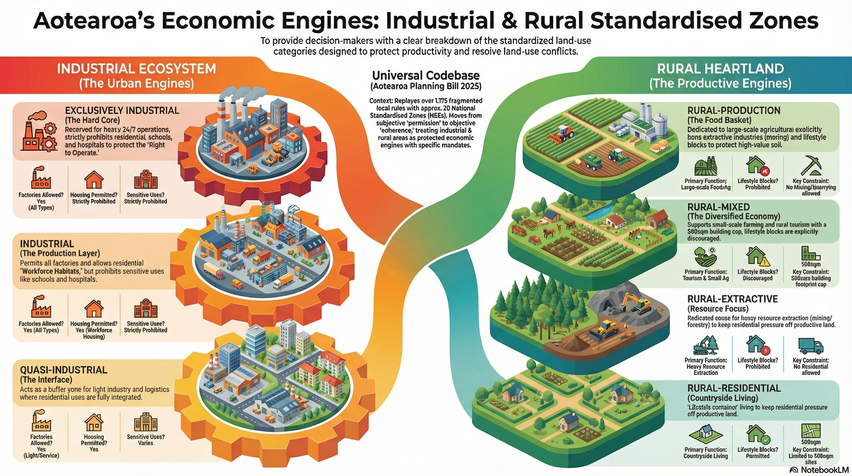
5. Typology 4: Rural Productive Ecosystems (The Urban Dam)
The macro-strategy uses a “Hydraulic Model” to manage growth pressure. The region is strictly divided by the Urban Dam to prevent the financial drain of low-density expansion.
Key Insight: The “Urban Dam” kills land speculation. By making the Urbanisation Control Area (UCA) a hard legal line where subdivision is prohibited, land value is decoupled from “housing hope.” Farmland remains priced for food production rather than speculative suburbia.
The Rural Zone Matrix
- Rural-Production: Reserved for large-scale Ag/Hort. Lifestyle blocks and Mining/Extractive industries are prohibited here to ensure total soil protection.
- Rural-Mixed: Focuses on tourism and small-scale agriculture; lifestyle living is discouraged.
- Rural-Extractive: Dedicated to mining, quarrying, and forestry; segregated from food/tourism zones via overlays.
- Rural-Residential: The designated “Quarantine Zone” for countryside living. Lifestyle blocks are capped at a strict 500sqm coverage to prevent land fragmentation.
These categories are unified by a shared requirement for biological infrastructure: The Green Utility.
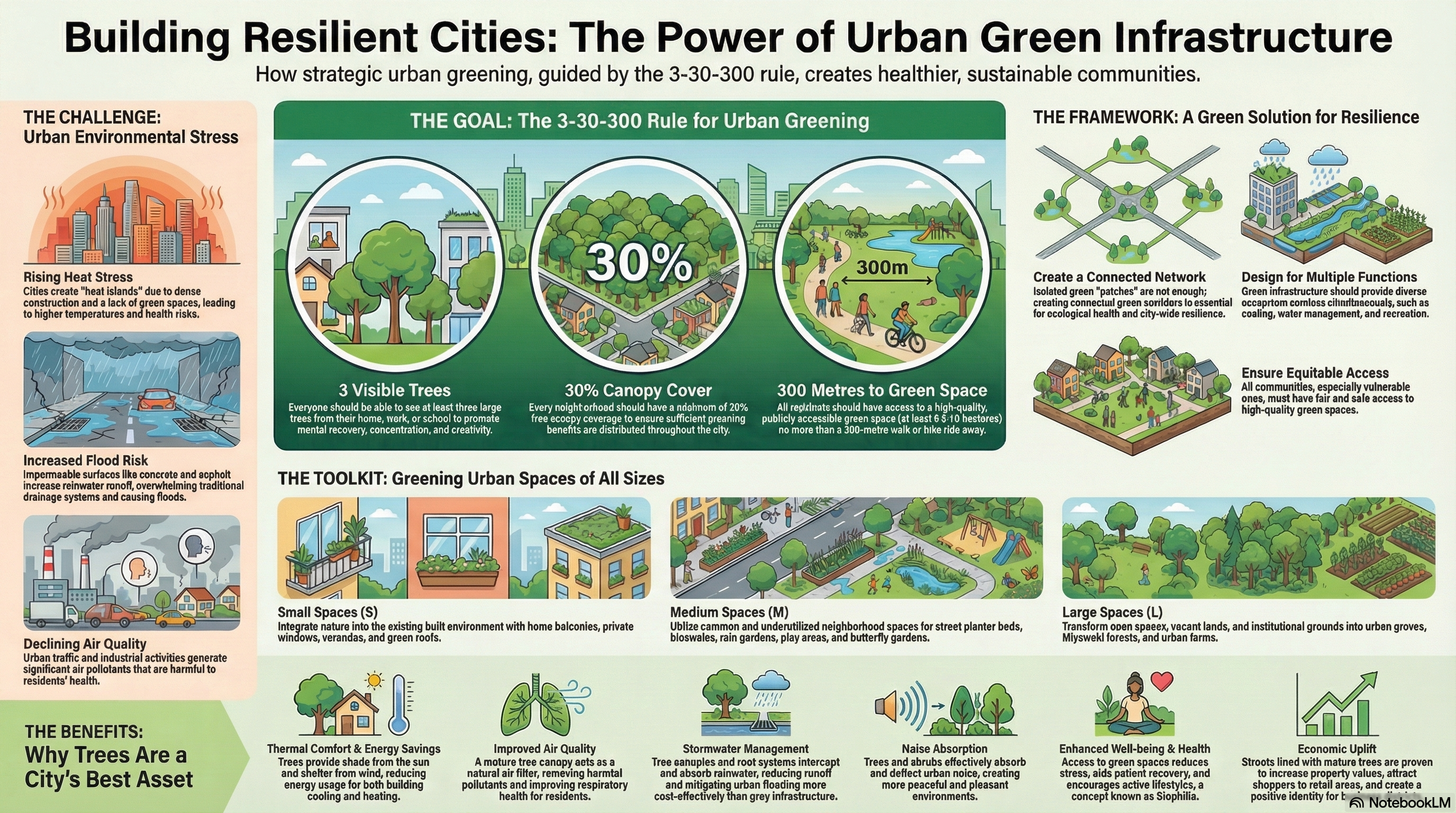
6. Cross-Typology Mandate: The Green Utility (3-30-300)
In the Urban OS, nature is not a decoration; it is mandatory infrastructure with a Triple ROI: a 1:3 return on maintenance, 1:18 in health savings, and 50% CAPEX savings on stormwater management.
The 3-30-300 Checklist
- [] 3 Trees: Every resident must see at least three mature trees from their home window.
- [] 30% Canopy: Every neighbourhood must achieve 30% tree canopy cover to mitigate the “Urban Heat Island” effect.
- [] 300 Meters: Every doorstep must be within 300 meters of a high-quality park.
Resilience & Risk Management
- Sponge City Logic: High-risk areas are converted into Blue-Green Corridors (wetlands) to manage stormwater.
- The Red Line Policy: As per the 100-year climate horizon (2126), development is strictly prohibited in the “Top-Left Risk Quadrant” (High Likelihood + Catastrophic Consequence).
- Connected Soil Volumes: To prevent “concrete coffins,” street trees must be planted in continuous underground soil trenches to ensure they reach maturity and function as true infrastructure.
7. Conclusion: The 15-Minute Reality
The Aotearoa Urban Operating System eliminates “Junk Miles” and activates the “Linger Factor,” where pedestrian-centric design captures 66% more consumer spending than car-dependent roads. By replacing 1,175+ fragmented zones with a Universal Codebase, we provide legal certainty and ensure the spaces we build actually build us.
The Permitted Activity Audit
Assess if a development qualifies under the Operating System:
- Location: Is the site within the UPA (The Reservoir) and outside the Red Line Policy flood zones?
- Density: Does it meet the mandate (6 storeys for Rail / 3 storeys for Bus)?
- Commerce: Are corner shops (under 150sqm) included As-of-Right?
- Acoustics: Has the Newcomer Principle (Hard Shell mitigation) been applied?
- Math Adherence: Does the bulk fit the Floor-Space Ratio (FSR) and Sunlight Plane (The Chisel)?
- Health: Does it meet the 3-30-300 Rule with Connected Soil Volumes?
- Connectivity: Is the grid permeable for an 8-year-old on a bike?
If the answer to all is “YES,” permission is guaranteed. The system is ready.

