
Alteration to give more frequencies on Western Line
Transport Blog put up a double informative post covering the City Rail Link tender announcement as well as run patterns once the CRL is open.
You can read on the tender side of the CRL here: Tendering to start for rest of CRL
What caught my attention was the proposed run patter for the City Rail Link once it opens. That is how will the trains run and what frequency will they run at across the respective Lines. More to the point will the frequencies be able to handle the demand given population growth over the next thirty years?
This is what Auckland Transport have proposed as of yesterday:


And yes to quote Transport Blog:
Note to AT: if your operations diagram is easier to understand than a more customer centric map then you’re doing it wrong.
…….
I feel sorry for those on the Western Line stuck with shitty six trains per hour especially past Henderson to Swanson and barely get there with nine trains per hour in the peak (still six past Henderson). In the meantime the Southern and Eastern Lines get right up to 18 trains per hour depending on time of day (6-12 is the normal) so something is a total miss here. Given there is a lot of residential growth forecast via the Unitary Plan in West Auckland I think bringing their basic frequencies up to 12 trains per hour from Swanson will be considered an absolute minimum.
While Southern Auckland also faces high residential growth (in fact some of the highest) it also faces strong growth in Manukau City Centre and the large industrial complexes scattered throughout the sub-region. So having a decent frequency both on and off-peak matters to the South (as it does to the West) but keeping the run patterns simple is also the key.
Hence why I have proposed this MK3 version of my own CRL running pattern:
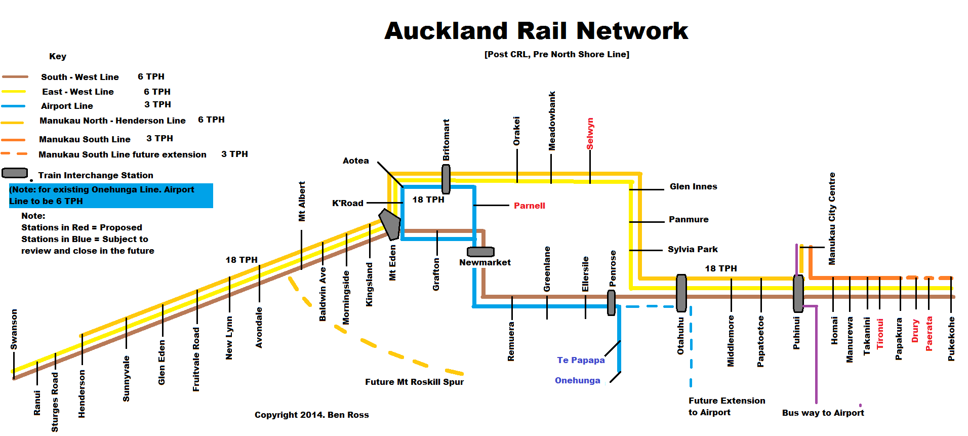
Some differences being:
- Eastern Line trains run from both Manukau and Pukekohe (allowing a maximum of 12-18 trains per hour when combined with the Southern Line) towards the City Centre allowing for maximum capacity
- At the moment I have the Southern Line skipping the CRL stations and going directly out West. I am inclined given the CRL can handle 24 trains per hour to bring the Southern Line through the CRL and back out on the Western Line for maximum capacity and flexibility. The Airport Line (currently Onehunga) would handle South to West if need be
- The Manukau to Henderson Line would divert to Mt Roskill if the Spur was ever built forming the Mt Roskill to Manukau Line
- Between Puhinui and Henderson your minimum train frequencies (factoring the Onehunga Line would go to Otahuhu Station instead forming an Otahuhu Shuttle until the Airport Line is built) is 12 trains per hour with heavily patronised sections like the CRL, Henderson to the CRL and between Puhinui (see below) and Otahuhu hitting 18 trains per hour (every 3:20 minutes)
- Given a busway from Manukau to Puhinui to the Airport via State Highway 20B is likely to be built soon Puhinui becomes a major interchange point for Airport passengers and hence the 18 TPH level at that station
- Onehunga Line would close if the Airport Line via Otahuhu were to be established (running at 6 TPH but can hit 12 giving the maximum of 24 TPH through the CRL)
- I have the Manukau South Link included to allow separate movements between Pukekohe and Manukau City Centre to keep the Southern and Eastern Lines clear for through passengers

Source: Auckland Transport
The run pattern I have tried to establish is to allow decent frequencies between the Metropolitan Centres that sit on the rail network and the City Centre. At the same time decent frequencies and connections to either Airport Rail, bus way or both is intended from this run pattern as well. With Albany and Takapuna Metropolitan Centres connected to the Northern Busway that connects back to Britomart only Westgate and Botany (until their bus ways are built) are left out from the Rapid Transit Network linking the Metro’s, the City Centre and the Airport all up. In other words I have tried to maximise catchments in, around and between our big centres.
What do you think and what would you change?

