
Lessons in Sydney can teach Auckland
Urban Geography
Urban geography is a branch of human geography concerned with various aspects of cities. An urban geographer’s main role is to emphasise location and space and study the spatial processes that create patterns observed in urban areas.
Source: An Overview of Urban Geography – About.com
As Sydney tries to grapple with its population and urban growth their leaders and communities are beginning the serious motions of creating a new ‘city’ built around the proposed Badgerys Creek International Airport. Creating a new city (New West Sydney Aerotropolis Gives Rare Opportunity to Design New City) is a rare opportunity indeed and even more rare when the extra challenge of connecting it back into an existing city is required.
The lessons from what is a live experiment in Urban Geography (and the sub discipline of Geography I specialise in) should be taken note of back here in Auckland as we as a region are about to embark on a similar exercise. Okay Auckland is not building a new international airport but the growth pattern projections set out by the Unitary Plan mean a particular sub-region (Southern Auckland) will go from housing 38% of Auckland’s population to 45% by 2042 (the end of the Auckland Plan). Couple this population growth with business growth (mainly industry) and our conventional thinking based around the City Centre and inner suburbs does not quite work.
I have mentioned before Auckland alone does not have the resources to invest in its growth in a scatter gun manner with our levels of infrastructure inconsistent across the City. It means some sub-regions are pretty much set up ready to go with their infrastructure while others need a lot of work before they should accept large amounts of new urban development. Examples would be the Isthmus not ready until the Central Interceptor is built while the North West (Westgate) is not ready until SH16 is upgraded to Kumeu and the bus way is actually built. In contrast Southern Auckland is pretty much set to go although it too needs the Southern Interceptor replaced at a cost of $700m. Consequently it would be wise for Auckland to divide up its growth and allocate it out to the sub-regions best suited for that growth now until the other areas catch up in investment (How to Handle Auckland’s Growth: Do We Divide Up or Go All In?).
All this said even if we divided the growth up and allocated it to the sub-regions on a rotating basis one geographic factor remains – the bottleneck at Otahuhu caused by the Isthmus being at its narrowest point. Otahuhu is a bottleneck as there is only a single motorway and single set of rail lines that connect the Isthmus (and Northland) back to the South and the rest of the North Island. Yes we have State Highway 20 crossing the Manukau Harbour to the west but that only acts a bottleneck itself meaning Auckland realistically only has two motorways and a rail line to shift people and goods around the place. The question fast becomes if the South is to increase its population loading from 38% to 45% of Auckland’s total population while the City Centre on the Isthmus continues to expand can our transport bottlenecks take the increased strain from those extra commuters.
The answer is even with the Third Main and the City Rail Link the bottleneck at Otahuhu and Mangere Bridge would not be able to take the increased strain from movement between the Isthmus and the South.

Back to Sydney. Sydney although not constrained by an isthmus as Auckland is does face a similar situation in terms of transport bottlenecks. Like Auckland, Sydney’s City Centre and inner suburbs are booming. However, and also like Auckland, Sydney’s West (so Auckland’s South) are also taking up a large proportion of both population and industrial growth (as industry decamps from the east and goes west). For the third similarity between Sydney and Auckland, Sydney’s west is link to Sydney’s City Centre by Paramatta Road (soon to be the West Connex motorway) and two heavy rail lines with one coming in from Penrith and Paramatta and the other from Liverpool (south west of Paramatta). Three transport links between west and east moving an increasing commuter load in Sydney just as State Highways 1 and 20 and the rail line move the increasing load from Auckland’s South to Auckland central.
Sydney and New South Wales knows despite the West Connex Motorway, Light Rail to Epping and Parramatta, and improvements to the heavy rail network it can not afford to move all those people in Sydney’s west to work in Sydney’s east without the entire transport system keeling over. Auckland also knows (but fails to acknowledge) that despite improvements to State Highways 1 and 20, and the rail network (whether it be the Third Main or the City Rail Link) trying to move all those people from the South to work on the Isthmus will result in the transport system keeling over like Sydney’s would.
So what to do?
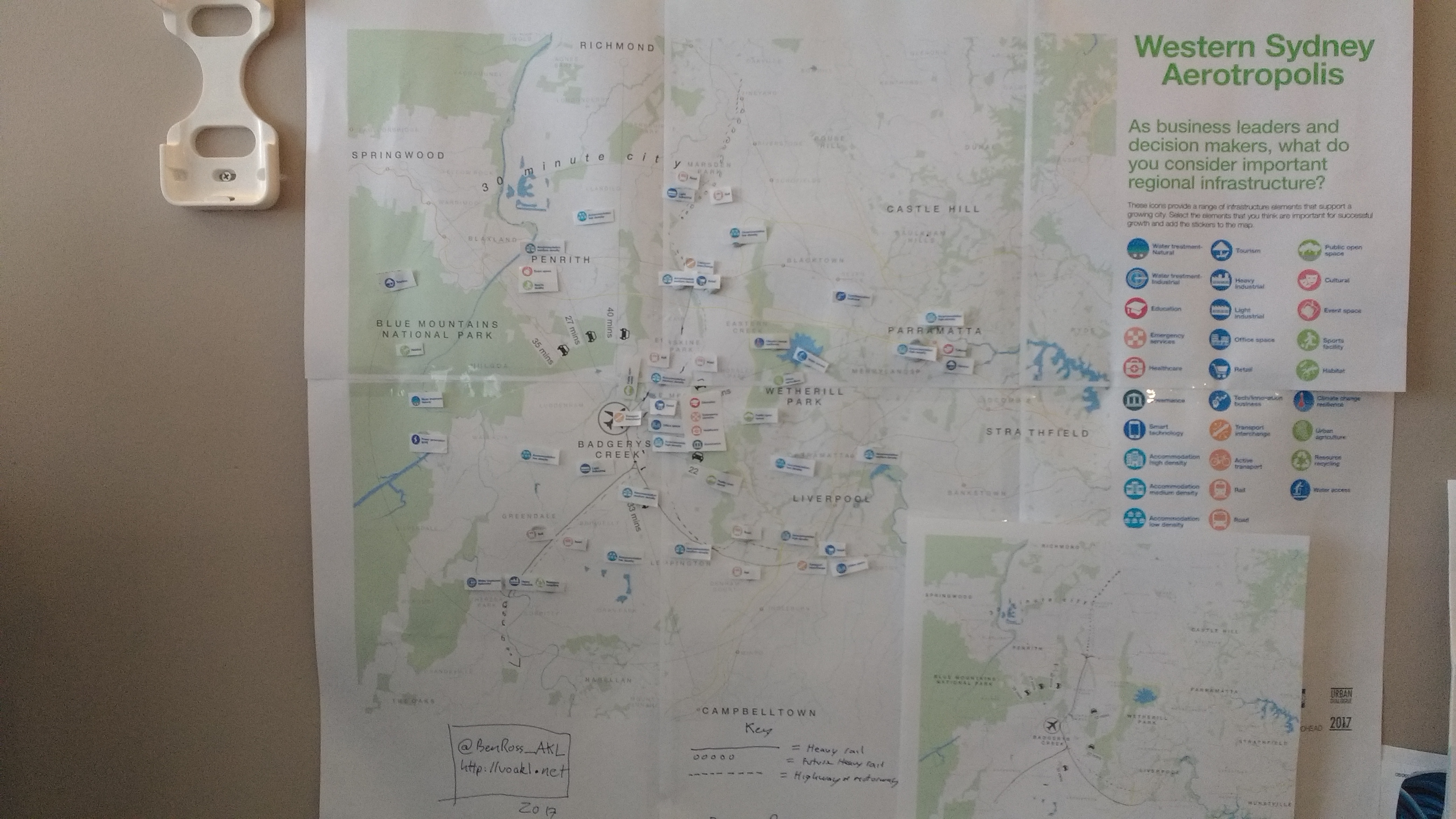
Sydney’s answer is two prong given its share size. The New South Wales is trying (as the first prong) to get Parramatta up to full power so it can function as Sydney’s second City Centre so that those in Sydney’s west do not need to commute further east thus relieving pressure on their transport network. As the second prong to try to keep Sydney’s west commuting within itself (much as Southern Auckland does) the NSW State Government is building Badgerys Creek Airport with subsequent large-scale residential, commercial and industrial development around it. By large-scale I mean enough independent development to spawn a new city not extend a current one. The Badgerys Creek Airport Aerotropolis can be read up on here: New West Sydney Aerotropolis Gives Rare Opportunity to Design New City.
I am closely watching the Badgerys Creek Airport development as it can give valuable lessons to Auckland on how to handle our skewered population and business growth. As I said before the South is taking the bulk of new residential and industrial growth. At the same time the main City Centre is fast expanding and as a consequence it means increasing commuter pressure on the Otahuhu and Mangere Bridge transport bottlenecks previous mentions.
From Stuff:
Pattrick Smellie: Bill English struggles to offload a billion dollars
PATTRICK SMELLIE. Last updated 05:00, February 23 2017
The Auckland Council has gone back to its plans for major infrastructure in new housing areas, to get a clearer idea of how new housing will look.
OPINION: If there’s one thing Bill English loves to do, it’s to put the slipper into local bodies about urban planning.
It’s a habit he developed as finance minister, where his exposure to the grindingly slow and too often restrictive processes of urban planners became his bete noire and go-to excuse for the Auckland house price explosion and supply shortfall.
Planners, he has often said in the last few years, are one of the principal causes of household poverty because their restrictions on where housing could be built and rules that added to their cost had helped drive property developers out of affordable housing and into building only for the wealthy.
The evidence from post-quakes Christchurch is that New Zealand is capable of building a great deal of affordable housing very quickly in a crisis.
“The real challenge is whether councils actually do have projects waiting for infrastructure funding,” Prime Minister Bill English says.
As a result, Christchurch house prices are static compared with Auckland’s.
In Auckland, the supply shortage has been self-induced, welcomed by existing property owners for the “wealth effect” of higher house prices, and has proven achingly slow to deal with.
While new supply is now starting to emerge, Auckland still needs a lot more houses.
With a lot more houses comes the need for a lot more infrastructure, which is where an interesting subterranean spat has been playing out between central and local government over recent months.
Back in July last year, the Government reacted to the calls from fast-growing cities – mainly Auckland, but Tauranga, Hamilton, Queenstown and Christchurch as well – for assistance to pay for the roads, sewers and water services that underpin any new housing development.
This was “only for substantial new infrastructure investments that support more new housing”, not plans already on the books.
Fast-forward to the first of this month and a little-noticed Government statement suggesting a rather feeble appetite for all this free money.
It encouraged councils “to be more ambitious in their final proposals”, saying that “only a small number of the 17 proposals received … would result in projects being advanced earlier than previously planned”.
…….
Politics of this aside what Prime Minister Bill English is doing (the slipper and urban planning) has very serious consequences to Auckland and its infrastructure.
The Southern Future Urban Zone is the largest in Auckland with enough yield for 55,000 homes (at low and medium density levels) and a new heavy industrial complex (Drury South). The 55,000 new homes means (on a 1:3 ratio) means 165,000 new residents on top of Transform Manukau’s 25,000 new residents. Combine this with redevelopments in the Mixed Housing Urban Zones (try two houses on two sections of land becoming eleven) and continued expansion of the City Centre further north and we have a problem. That problem being trying to get those residents to work on the Isthmus through that transport bottleneck. What makes the problem compounding is that I have reliable word that developers and businesses are looking at Southern Auckland as first choice for new homes and businesses. While we will get some in Manukau and existing areas it ultimately means all the Southern Future Urban Zone being opened up within a decade not thirty years (no matter what Council thinks).
Development at warp speed!

How can we handle this growth in the South without the transport network keeling over at Otahuhu?
We need to follow Sydney’s West and develop a new de-facto city, a city that encourages people to live and work within the Southern Auckland sub-region and knock off the “requirement” to work further north. Like Parramatta acting as the City Centre for Sydney’s West, Manukau City Centre acts (although informally for Auckland’s case) as the South’s City Centre or rather core. So we have a core for the South in place and under urban regeneration, what is needed next is a very comprehensive plan on managing Southern Auckland’s growth and development. You could do a ‘Southern Auckland Plan’ – within the MK2 ‘Auckland Plan.’
In doing this Southern Auckland Plan we need to look at this hypothesis:
As Auckland continues to evolve most of the urban growth in terms of population, commercial and (especially) industrial employment will (outside of the City Centre) occur south of Otahuhu and the Tamaki Estuary (and into the Northern Waikato). The Southdown-Onehunga industrial complex is decamping from the Isthmus to the ‘South’ as land-use pressures from residential and commercial demand encroaches into the complex. The South also has the most residential, commercial and industrial zoned (Brownfield and Greenfield) land available as a consequence of the Unitary Plan. Auckland is also geographically land constrained by a narrow isthmus (at Otahuhu) causing transport bottlenecks at Otahuhu and Mangere Bridge. As a consequence of the above will:
- The Centre of economic and residential population Gravity drift from the City Centre and Isthmus south into Southern Auckland[1] and the Northern Waikato[2]?
- If so are our planning mechanisms set up for the drift? Whether if so or not how can we reinforce our planning mechanisms to handle the Centre of Gravity drift south?
[1] Southern Auckland is defined as the following Auckland Council Ward areas: Manukau, Howick, Manurewa-Papakura, and Franklin
[2] Northern Waikato is defined as: East West along State Highway 20 from Kaimai Ranges to Hamilton City, and out west to Port Waikato
It might be time to get the map, pencil and stickers out and engage in a GHD Aerotropolis exercise!
If we are to get the growth right in Auckland without our transport system keeling over all eyes should be set to Sydney and how they engage with Parramatta, and Badgery Creek Airport.

