A Plan is no plan if it does not have targets to reach
It has not escaped my attention that the Auckland Plan 2050 (the refresh) is lacking hard targets to track how we are doing as a City in reaching our goals. Greater Auckland has noticed this as well in their blog post over here: The refreshed Auckland Plan is here. The current version of the Auckland Plan does have targets and each year an annual report would be released on how well we were meeting those targets (or not). This has been done away in the Refresh which means the document as a whole can be seen as well twaddle.
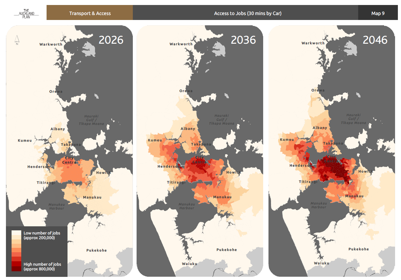
One goal (as it is heavily related to Urban Geography) is accessibility to jobs by car or transit. The rule of thumb is that you want as much as your residents as possible within 30 minutes of their work by car or 45 minutes by transit (including the walk up to the stations in most cases). The Auckland Plan 2050 attempts to do this here:
Auckland Plan 2050
Source: Auckland Council
Auckland Plan 2050
Source Auckland Council
Note: these are projections not targets.
Targets would have the Auckland Plan dictate the following:
- 2025: 33% of residents within 30/45min of their jobs
- 2030: 50% of residents within 30/45min of their jobs
- 2042: 75% of residents within 30/45min of their jobs
- 2050: 90+ of residents within 30/45min of their jobs
This target would also tie into the Auckland Plan’s updated Development Strategy around NODES.
From the Auckland Plan 2050:
A multi-nodal model
Over the next 30 years, Auckland will move towards a multi-nodal model within the urban footprint.
The city centre will continue to be the focus of Auckland’s business, tourism, educational, cultural and civic activities. It will continue to be an important residential centre as well.
But it won’t be the only main centre in Auckland.
The areas around Albany, Westgate and Manukau will emerge as nodes which are critical to growth across the region.
They will become significant hubs of a broad range of business and employment activity, civic services and residential options.
These areas, with their large catchments, will accommodate substantial growth in the north, north-west and south and will be interconnected by a range of efficient transport links.
Outside the core urban area, the satellite towns of Warkworth and Pukekohe will act as rural nodes.
They will:
- support significant business and residential growth
- service their surrounding rural communities
- be connected to urban Auckland through state highways and, in the case of Pukekohe, by rail.

Auckland Plan 2050
Source: Auckland Council
……..
I will cover the Nodes in-depth in a later post but long story short the main bulk on intensified urban development will be around these nodes (and the heavy industrial complexes). The jobs accessibility by car/transit will have a major influence to how the nodes develop as Auckland continues the Compact City approach. Having targets as I have mentioned above not only influences our Urban Geography but other goals in the Auckland Plan such as climate change (emissions reductions), physical environment and social environment (including productivity) as well.
Targets also tell us where we are doing well and where we are failing so that policy can be adjusted accordingly.
Let’s gets some hard targets set into the Auckland Plan 2050 please Auckland Council otherwise the document is rather meaningless if we want to measure our progress in being:
The World’s Most Liveable City!

