
I appreciate prompt responses and comprehensive ones at that
Earlier in the month I had some questions to NZTA and Auckland Transport over how the future of Southern Auckland’s transport network would pan out. You can see those questions here: Serious Questions to NZTA and Auckland Transport Over Supporting Growth – Southern Auckland: Does Not Match ATAP or Auckland Plan

Subsequently the Supporting Growth Alliance – South sent back a list of answers on my questions. Below is the conversation on said matter:
Thank you for your interest in the Supporting Growth programme. The south is the largest future urban growth area in Auckland with around 5,300 hectares of land identified for urban development. This could result in 42,000 homes and 19,000 jobs over 30 years. The projection for overall growth in the south has increased by more than 30% since the Transport for Future Urban Growth (TFUG) programme was published in 2016. This means that we are now also considering additional ideas to support the future urban growth over the longer term.
The aim of the current phase of planning work is to reassess the original network plans in light of the new growth projections, the latest land use planning being progressed by Auckland Council, and the Government’s new priorities, and investigate a range of options, before completing business cases for projects. Ultimately we are working towards staged route protection over the next few years. Route protection is a planning process that enables land to be protected for future construction of necessary infrastructure such as transport. It provides certainty to landowners and developers about where essential infrastructure will be in the future. However, while we are route protecting now, the construction or delivery of these projects will be staged over the next few decades, in line with growth. This approach of planning ahead for the long term allows us to benefit from future advances in technology, travel demand management, and network optimisation, when it comes time to deliver or construct the projects.
“In regards to the bus lanes on State Highway 1
What is the methodology for providing bus lanes down State Highway 1 from Drury to Manukau when:
- No Auckland Transport commuter service would use this as AT works on the priority of feeding into rail stations and the 33 Great South Road service
- No AT commuter service would use SH1 in the future given the above
It seems it would duplicating and waste resource for little gain when a Rapid Transit Network already exists (the Southern (rail) Line), a Frequent Service Network already exists (the 33 which can be extended to Drury) and future RTN (running a service down the upgraded Mill Road is prudent to build resilience if the 33 bus and Southern Line are impaired).”
The vast majority of people who live in the south need to travel north for work and at present, less than 10% of people in the south currently use public transport to get to work. We are considering upgrades to the rail network in the south to enable rail to play a much greater role in meeting the current and future travel needs of the south.
However, given the scale of growth anticipated in the south over the next 30 years, relying solely on the rail network may not be enough to support growth in the long term. We are therefore considering additional options for the Rapid Transit Network (RTN) to continue to provide access and mode choice from the South in the long term.
“What is the methodology of a RTN following the route suggest as (4) in the Strategic Connections PDF. Again like the bus lanes on State Highway 1 it would be duplicating existing RTN and FSN systems already in place (again the Southern Line and the 33 Great South Road Bus) and future systems (a service up Mill Road) which is wasting limited resource.
Furthermore (4) is very convoluted in its route and would no desire to deliver the outcomes one seeks in an RTN route (direct and express) it would not even meet the desire of a FSN route like the 33 Bus which sticks to one corridor.
Your route suggested is more like a convoluted feeder into the RTN and FSN that already exists. We already have such feeders known as the 365, the 362 and the 361 provided by Auckland Transport.
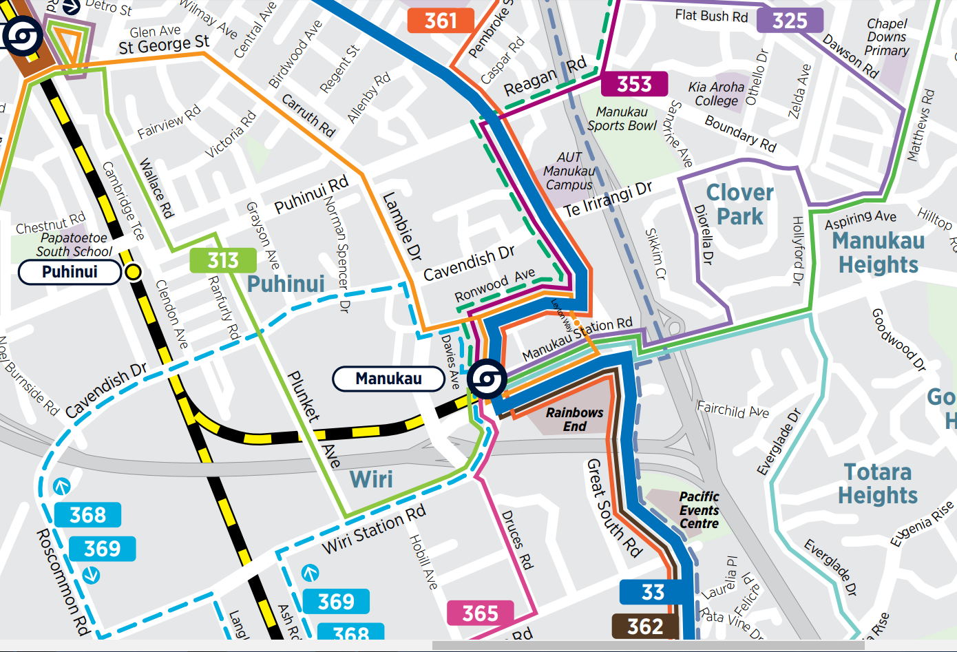
If you are looking at a future RTN as it were may I suggest starting at Manurewa Interchange, head south down the Great South Road to Mahia Road (and Te Mahia Station), down Mahia Road to the big Clendon roundabout, down Roscommon Road through to Cavendish Drive, and finally down Cavendish Drive to Lambie Drive and Manukau Station where the Eastern Line AND Airport to Botany Rapid Transit would link up.
This would allow a high socially deprived area a decent transit link to key transport interchanges and employment areas.”
The route shown is indicative only to demonstrate how a potential RTN could connect the future new growth areas that will develop over the next 30 years into current urban and employment areas. That is why the RTN is shown as starting further south, closer to Drury. Further technical analysis will be undertaken in the next phase of this programme, including analysing how such an RTN may support and integrate with current services over the long term.
We appreciate your feedback on a suggested alternative route, which will be considered as part of the feedback process.

Airport to Botany Rapid Transit
Speaking of which why is Airport to Botany Rapid Transit not mentioned at all in your Supporting Growth Southern Auckland documents when it is a key Rapid Transit Link in Southern Auckland that is:
- In the Auckland Plan 2050
- In the ATAP
- In the NLTP
- Is deemed absolute priority (Airport to Manukau section) by NZTA’s documents and by Transport Minister Twyford himself
- Actually supports growth in Southern Auckland by linking the Southern residential population to employment complexes such as: Airport, Manukau, East Tamaki and Botany via a transfer at Puhinui Station
Finally why is this (4) RTN proposal in your documents when it is not in the Auckland Plan 2050 Strategic Public Transport, ATAP or the NLTP (which sits over the RLTP)
The Supporting Growth Programme is working closely with the Airport to Botany Rapid Transit project team and the other projects that form the Southwestern Gateway Programme. The projects indicated in our programme consultation materials connect directly into these projects, and propose a range of options for extending the rapid transit improvements the Airport to Botany Project will deliver this decade, out further into the future southern growth areas over the next 30 years.
As noted above, the (4) RTN is a new option we are seeking feedback on that has been proposed as one way we could respond to the prediction that we will have 30% greater growth than previously expected in the south. We are seeking feedback on this idea alongside the other ideas also proposed for additional improvements in rail, Mill Road and the state highway. We would appreciate your feedback on what issues and opportunities you see with this range of ideas.

Your very first TFUG version of the transport system in Southern Auckland better reflects the ATAP, GPS, NLTP, Auckland Plan 2050, the expectations of the Minister Twyford and the Urban Geographic layout (current and future) of Southern Auckland:
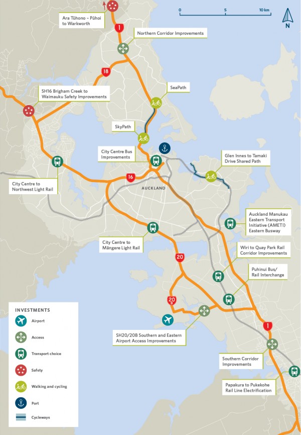
The Supporting Growth Programme is a progression of the work undertaken through the Transport for Future Urban Growth (TFUG) programme. In 2015-16, Auckland Transport, the NZ Transport Agency and Auckland Council worked together to investigate and develop a high level preferred transport network plan to support all four growth areas, and formed the Supporting Growth Programme (formerly known as TFUG). The resulting Supporting Growth Preferred Transport Network Plans were then completed and published in late 2016. These high-level maps showed a range of indicative transport connections required to support the growth in each area.
Since the release of these preferred network plans, several Supporting Growth priority projects have already progressed, and are moving through the business case and consenting phases. In the south, this includes the State Highway 1 Papakura to Bombay project. The majority remaining share of projects within the preferred network plans are now being taken forward by the Supporting Growth Alliance.
With an emphasis on public transport, walking and cycling, improving safety and broader environmental, health and urban growth outcomes, the Supporting Growth programme is well aligned with ATAP. Equally the programme is well aligned with the GPS which sets priorities for safety, access (including enabling choice and resilience), environment and value for money.
-ends-
Quite a bit there from the Southern Growth Alliance with there when one does their submission. Thus I highly recommend going to one of the Open Days and both see the information on big A0 boards and talk to the officials before sending in feedback.
Below are the Open Days and links to more information plus the submission form:
South Auckland
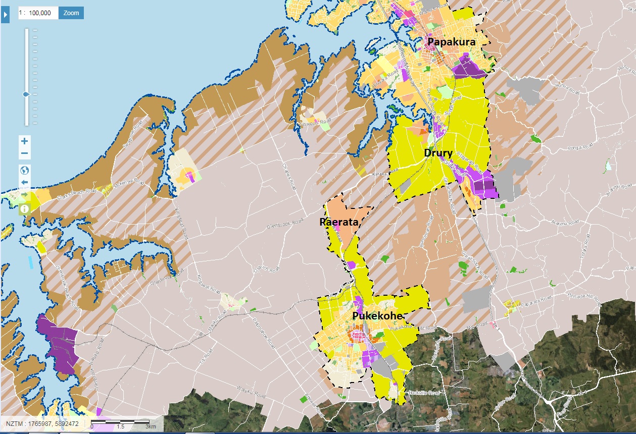
Auckland Council is developing structure plans for land use to guide future urban development in Drury-Opāheke and Pukekohe-Paerata. The Supporting Growth Programme is planning the transport networks to support growth in these areas, and Takānini, over the next 30 years.
Joint information open days are being held from mid September to early October, where you can hear about structure plan ideas and transport network options for these areas, chat to our teams and fill in feedback forms. You can also view the consultation information via the links further down this page and submit a feedback form online.
The open days are being held as follows:
| Date | Time | Venue |
| Wednesday 12 September | 2.30pm-8pm | Redhill Community CentreCorner 163 Dominion Road and Croskery Road, Papakura |
| Thursday 13 September | 2.30pm-8pm | Pukekohe Town HallMassey Avenue, Pukekohe |
| Wednesday 19 September | 2.30pm-8pm | Drury Hall10 Tui Street, Drury |
| Saturday 22 September | 10am-2pm | Auckland Council Manukau Civic Building 33 Manukau Station Road, Manukau |
| Tuesday 2 October | 2pm-7pm | Pukekohe Library12 Massey Avenue, Pukekohe |
| Wednesday 3 October | 2pm-7pm | Sir Edmund Hillary Library209 Great South Road, Papakura |
CONSULTATION INFORMATION:
General information about the Supporting Growth Programme [PDF, 14 MB]
The Growth Story: Pukekohe, Drury and Takānini [PDF, 666 KB]
The strategic network:
Strategic Connections [PDF, 4.1 MB]
The importance of public transport [PDF, 3.8 MB]
Access to Pukekohe [PDF, 2 MB]
Developing a walking and cycling network [PDF, 4 MB]
Takānini:
Improving safety and connectivity for Takānini [PDF, 2.5 MB]
Drury-Opāheke:
Land use vision for Drury-Opāheke [PDF, 641 KB]
Improving connections for Drury-Opāheke West [PDF, 10 MB]
Improving connections for Drury-Opāheke East [PDF, 2.6 MB]
Pukekohe-Paerata:
Land use vision for Pukekohe-Paerata [PDF, 463 KB]
Improving connections for Pukekohe-Paerata [PDF, 1.8 MB]
What these connections could look like in the south [PDF, 355 KB]
FEEDBACK:
Feedback form for transport options(external link)
Further information about Drury-Opāheke and Pukekohe-Paerata structure planning and a feedback form for this is available at www.aucklandcouncil.govt.nz/haveyoursay(external link).
Feedback closes at 5pm on Wednesday 10 October 2018.
So go to an open day and get your submissions in by October 10!


Why no commuter railway between Waiuku and Britomart via Pukukohe?
Insufficient demand to run a low patronage service on a freight branch line.
Easier to bus the passengers to Pukekohe or even Papakura and then train for the rest of the trip