Latest Milldale Residential Development Shows Large Urban Geography Shortfalls!
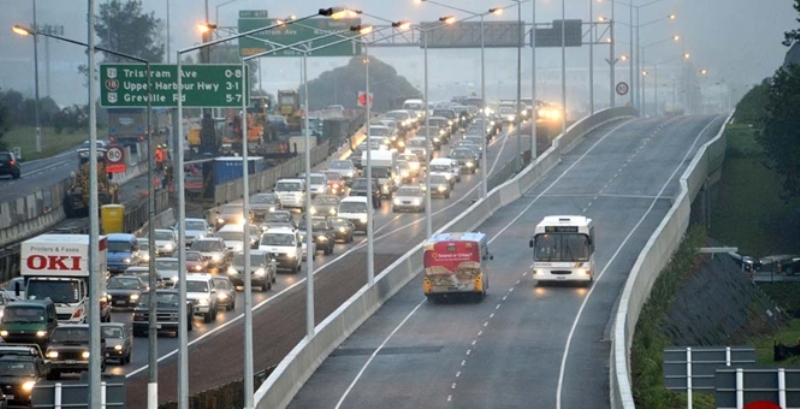
There was fanfare earlier this week in northern Auckland as Minister Twyford and Mayor Goff each turned a sod to mark a new Greenfield (sprawl) residential development out in Milldale (somewhere near Silverdale). The fanfare was more around how this sprawl development would be funded using a Special Purpose Vehicle (moving debt around) which results in the new residents in the development paying $1000/year extra to cover the debt costs of the new infrastructure to support the development. By infrastructure I mean water, sewerage and roads. Nothing for parks or transit (which becomes a critical point further down).
This was the presser on yesterday’s fanfare:
Major infrastructure partnership for North Auckland
Minister of Housing and Urban Development Phil Twyford and Auckland Mayor Phil Goff today announced a partnership that will fund $91 million of roading and wastewater infrastructure to support the building of 9000 homes at Wainui, north of Auckland.
The Government Special Purpose Vehicle (SPV) has been created in partnership with Auckland Council, Crown Infrastructure Partners and Fulton Hogan Land Development.
Phil Twyford said the Milldale project demonstrates an approach to funding that allows private investment in new infrastructure with the debt sitting on a balance sheet that is neither the Council’s or the Government’s.
“The Milldale project is an example of the innovative new approaches to financing infrastructure that the Government is developing through the Urban Growth Agenda. This funding model can be used in other high growth areas affected by the housing crisis to help more houses to be built more quickly.
“This could include private investment in infrastructure funded by a charge on the properties that benefit from the infrastructure.
“This new infrastructure funding model will result in a large number of homes being built much sooner than otherwise would have been the case.
“One of the major road blocks to our towns and cities growing is the lack of ready access to finance for the infrastructure that allows for new urban growth, for green or brownfields developments,” Phil Twyford said.
Phil Goff said Milldale will be a great place for Aucklanders keen to live in a new modern eco-friendly environment connected to the rapid transport network.
“A key priority for us in Auckland is to address the shortage and unaffordability of houses in our city,” Phil Goff said.
“We’ve zoned much more land for housing, but we need the infrastructure before we can build on it.
“Using Crown Infrastructure Partners to fund that infrastructure enables us to build roads, water and wastewater services without overburdening Council with debt and exceeding our debt to revenue ratio.
“We can build more homes sooner and tackle the housing crisis quicker than would otherwise have been possible.
“This Project enables nearly 4,000 new dwellings in Milldale and the infrastructure can support another 5,000 dwellings in the surrounding areas as well. It’s a big step towards meeting Auckland’s housing needs,” Phil Goff said.
Fulton Hogan Land Development has already started work on the Milldale development at Wainui, which will have nearly 4,000 homes and businesses. The infrastructure being funded will support the Milldale development and will also enable another 5,000 homes to be built nearby, with $33.5 million funding for this being provided by Auckland Council.
Crown Infrastructure Partners has secured long-term fixed-rate debt from Accident Compensation Corporation. The SPV will be funding $48.9 million towards the infrastructure, with the Crown contributing less than $4 million.
The SPV funding will be repaid over time partly by Fulton Hogan Land Development and partly by section owners as an ‘infrastructure payment’ collected with Council rates bills. This new model of infrastructure financing means that long term debt can be raised through the SPV to enable the building of large scale infrastructure, which is needed to step up the rate houses being built, and to assist Councils who are nearing their debt limits.
The Milldale development will be a modern, contained urban development with green spaces and parks, a town centre, cycleways and walkways, and potentially education facilities, and will be connected to the Northern busway.
Fulton Hogan Land Development in conjunction with a joint venture partner has previously developed Millwater, on the eastern side of the northern motorway and sees Milldale as the next evolution of this urban development.
Further Information:
- The infrastructure includes a new arterial road and bridge connecting Wainui Road to the Silverdale Interchange and Dairy Flat Highway, intersection upgrades, a roading extension and bridge to Highgate Parkway on the eastern side of the motorway, and wastewater tunnels.
- Construction on the infrastructure has already commenced (the wastewater tunnel) with the first residential sections to be released in the early new year.
- The infrastructure funding and financing pillar of the Urban Growth Agenda will enable responsive infrastructure provision and appropriate cost allocation, including the use of project financing and access to financial capital. It aims to reform infrastructure funding and financing through:
- Providing a broader range of tools and mechanisms to enable net beneficial bulk and distribution infrastructure to be funded;
- Rebalancing development risk from local authorities to the development sector; and
- Making long term debt finance available to developers willing to take on the commercial risk, with the debt serviced by revenue from the new properties in a development.
Source: The Beehive
Okay so we get some roads and some wastewater infrastructure funded via shifting the debt around and the new residents paying for it – aka the closest we get to Municipal Utility Bonds used in Houston, Texas. And yes Ratepayers end up paying a higher amount back due to higher servicing costs for the debt as well given said debt is not provided by the State (which always attracts the lowest rates due to its sheer size).
Otherwise for all the fanfare we and the new residents do not get much else. Where are the parks, where is the transit and most of all where are the places for work?
Southern Auckland has Manukau so where is Milldale’s Albany?
As was quickly pointed out yesterday after the announcement the issue of places of work and transit accessibility came to the forefront. That is: are provisions being made to beef up Albany Metropolitan Centre (a Node under the Auckland Plan 2050) so more jobs and civic infrastructure are provided closer to home. The more job opportunities and civic infrastructure provided closer to where one lives will often mean residents will have the choice is staying closer to home for work. When residents are presented that opportunity it means the road and transit network is under less strain from long distance commuters.
Geography of North Auckland
Northern Auckland consists of the North Shore, Albany and Rodney Wards. It has mixed urban, suburban and rural geographies just as Southern Auckland does and like the South it also has transport pinch points – the Harbour Bridge and State Highway 18. Northern Auckland does contain one substantial industrial complex at Rosedale although it is not part of the five heavy industrial complexes south of the Bridge. Northern Auckland also has two Metropolitan Centres – Takapuna and Albany for which Albany is one of the three Nodes in Auckland (the other two being Westgate and Manukau).
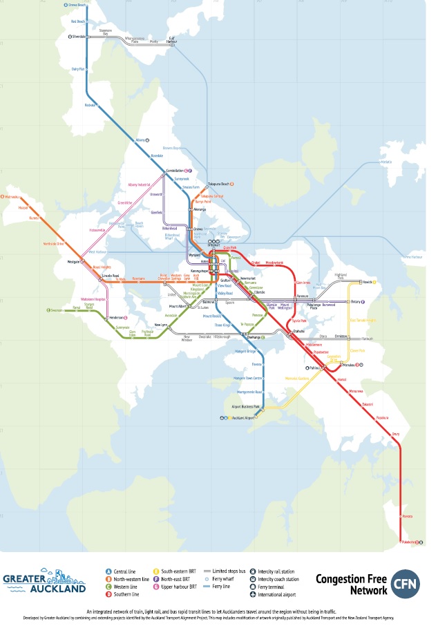
Rapid Transit wise Northern Auckland is connected to the City Centre via the Northern Busway. In the future the busway would be upgraded to Light Rail connecting it with the City Centre to Mangere Light Rail line (CC2M) while Bus Rapid Transit connecting Constellation Drive to West Auckland, and Constellation Drive to apparently Botany (so an extension of the Eastern Busway) are mentioned in the Congestion Free Network 2.0.
In terms of population and employment growth (per the Auckland Transport Alignment Project) the North would be ranked third of the four sub regions behind Southern Auckland and the Central Isthmus.

The above map shows where Milldale is; in the middle of nowhere with no connections to the Northern Express busses at Silverdale.
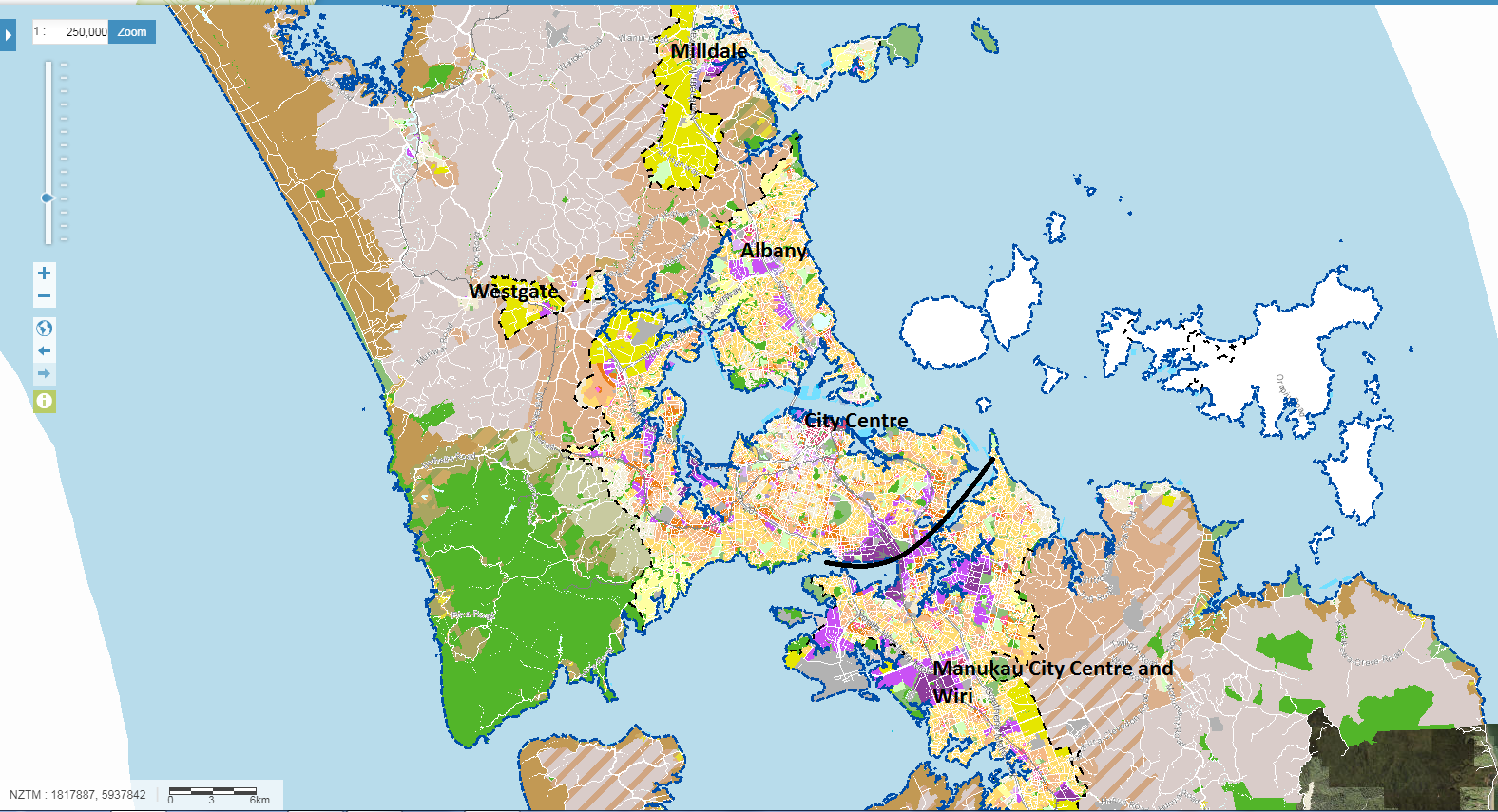
The above map shows where Milldale is in relation to the City Centre with Southern Auckland, Manukau and Wiri also illustrated as a contrast. The black line delineates Southern Auckland from the rest of the City.
The purple/cyan colours denote Light and Heavy Industry while the Magenta denotes Metropolitan Centres. The yellow is the Future Urban Zone.
Looking at the Auckland Unitary Plan map the South is blessed heavily with industry and three Metropolitan Centres (one being a Node) that are reasonably connected well by transport (and even more so in the future with projects like Airport to Botany (see: Airport to Botany (A2B) Rapid Transit Briefing to Local Boards Out. Progress Continues with Consultation Due)). The North is also relatively blessed with two Metropolitan Centres (again one being a Node) and the Rosedale industrial complex. However, where it differs for the North and South is how their respective Nodes have developed and/or are planning to be developed.
Manukau is under the Transform program set by Panuku Development Auckland, Albany is not. This means through the next thirty years Manukau will be under intensive planning, investment (public and private) and development with an end goal being Manukau reinforced as the core of the South so people have the choice not to travel to the City Centre for work, recreation or civic needs.
Albany is under no such program via Panuku and as a Metropolitan Centre it is highly underdeveloped with large tracts of land being grass/blank land. While urban development is occurring (apartments and some offices) it is very piecemeal with no logical approach. The roading network also does not help inside Albany Metropolitan Centre meaning it takes longer than it should to cross the Centre unlike Manukau with its grid street pattern and laneways.

What to do with Albany?
Albany is a Node under the Auckland Plan meaning it will become the civic and commercial core for Northern Auckland just as Manukau is with the South. However, while resources are stretched a Master Plan to guide Albany Metropolitan Centre’s future is sorely needed make sure Albany does reach its full potential
To make sure Albany does reach its full potential the Master Plan would need to map out:
- Where and when the Civic hub will develop
- When will light rail reach Albany (replacing the Busway)
- Quick wins with cycling and walking link ups given Albany lacks laneways and a grid street pattern
- Interim transit priority measures for busses
- Government involvement for metro-class schools
- What is Albany’s ultimate goal
Once the Master Plan realises and expresses the above then we can get to work to ensure the North has its Albany much as the South has its Manukau. Remembering that by beefing up Albany to its full potential as a Node those who will live in Milldale will have an actual choice of being able to work closer to home, to shop closer to home, to play closer to home compared to having to make the daily trip to the City Centre.
Not only does work, shop and play closer to home ultimately mean more family time it also relieves pressure on a single transit line connecting the North to the rest of Auckland – the Northern Busway later to become the North Shore (light rail) Line.