
Reflections on the Japanese Planning System
Let’s kick off on what the Japanese regulators are around land-use (aka Planning).
Note: the PDF version of the Wiki article will be at the bottom of the post.
Land Use Law (1974 – Japan)
The reason of the Land-Use Law enacted in 1974 was concentration of population and industry in major cities, speculative land investment, abnormally high land prices, and chaotic development. To solve this problem, it has fundamental principles:
- firstly, the public welfare is above all considerations,
- secondly, there must be a planning for natural resource preservation,
- thirdly, healthy and cultural living environments must be protected,
- fourthly, there must be planning for balanced development of land use.
Which level of Government does which aspect of Planning in Japan give the above law
Government authority over designation of zoning
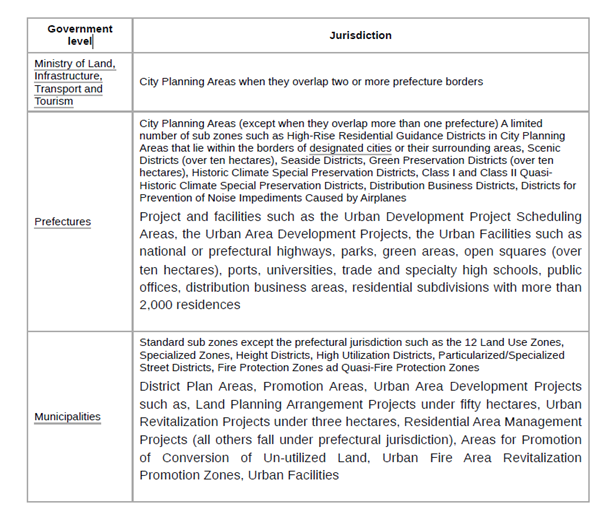
National Plan, Prefecture Plan, Municipal Plan
All three levels of government, national, prefecture, and municipal are all involved with the law. It requires all three levels of government to create plans for uses of national lands.
- Starting with the National Land-Use Plan or the National Plan that was prepared by the Ministry of Land, Infrastructure, Transport and Tourism, then it must be approved by the Cabinet.
- Based on the National Plan, there are the Prefecture Plans.
- Based on the Prefecture Plan, there are the Municipal Plans.
In an Aotearoa context:
Central Government drafts the National Land Use plan or The National Spatial Plan
Regional Councils* would then draft their Regional Spatial Plans and single regulatory plans with the National Standardised Zones (NSZs). NSZs include the base Urban and Rural Zones.
City and District Councils would draft the sub zones, District Plan areas and smaller renewal areas, urban facilities, and “urban/rural development” areas.
*Unitary Authorities such as Auckland Council have the merged Regional and City/District Council roles.
Land Use Zones
Twelve of thirty sub zones, the Land Use Zones, is a building control on land which regulates land use and building form, consist of 8 types of residential districts, 2 types of commercial districts, 3 types of industrial districts that mostly prepared in the UPA. For example, hotels cannot be built in low density residential district. Each district regulation is decided by the building coverage, floor-space ratio, height limitation, floor-space ratio limitation of road, diagonal line limitation for road and adjacent land, and shadow area limitation. All of criteria are related to the Building Standard Act.
There are 13 land use zones.
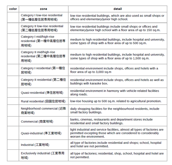
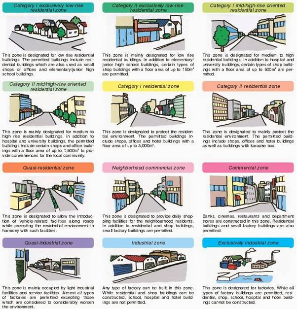
Figure 1: Japan Base Zones
Overlays, Specialised Zones, Promotion Area Zones, District Plans, and City Planning Projects all come as sub layers that can be put over the top of an above base zone. Rural and Conservation Zones are managed by Basic Land Use Plans.
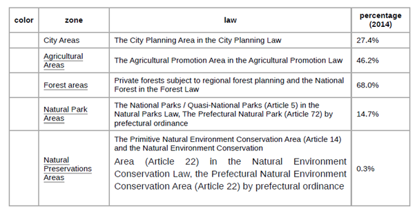
Basic Land-Use Plan
Prefecture governments must create the Basic Land-Use Plan (BLP), based on the Prefecture Plan. The BLP specifies the five zonings, similar to sub zones of the City Planning Law but in bigger scale. Different laws apply on these five zones, and they can be overlapped, more than one zones can be designated in one area.
Aotearoa Context
The Japanese Land Use Zones is the inspiration behind the National Standardised Zones in Aotearoa. Easy to read and straight forward in application no matter where you are in the Motu.
The Basic Land Use Plans would be the closest version to the Spatial Plans written in Aotearoa, and soon to be compulsory under the incoming Planning Act!
Japan does have overlays, and special zones that can apply over the base 12 land use zones. They are site or local geographic specific and often need sign off by a Prefecture (Regional Council) or the Minister/Cabinet (Central Government) if over a certain size or deemed of major significance.
This would match applying Overlays, or Bespoke “Zones” over an NSZ base zone at a case-by-case basis either at Regional or Central level.
Large-scale developments are handed by City Planning Projects in Japan. This would be the same as Drury South going from Future Urban to live zoning and undergoing urban development.
Promotion Area Zones are used for development of an underutilised area. Transform Manukau by Eke Panuku in Auckland would be a case example of a Promotion Area Zone as an Overlay to the respective base NSZ’s the area is sits on (it can be more than one NSZ as well).
Rural Zones
The Japan planning system does not have specific rural zones as Aotearoa does. Given Aotearoa still has an extraordinarily strong agriculture and horticulture economy to urbanised Japan, some specific rural zones would be useful to add to the NSZ’s. Future Urban Zones which are rural lands set to become urban I will cover in the next subsection.
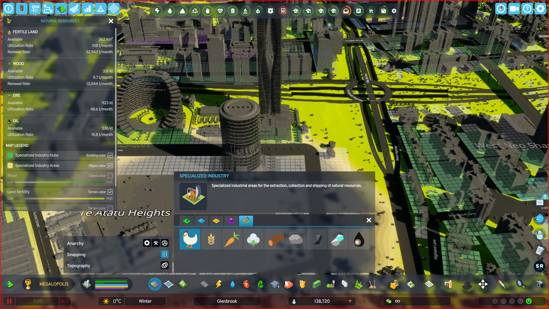
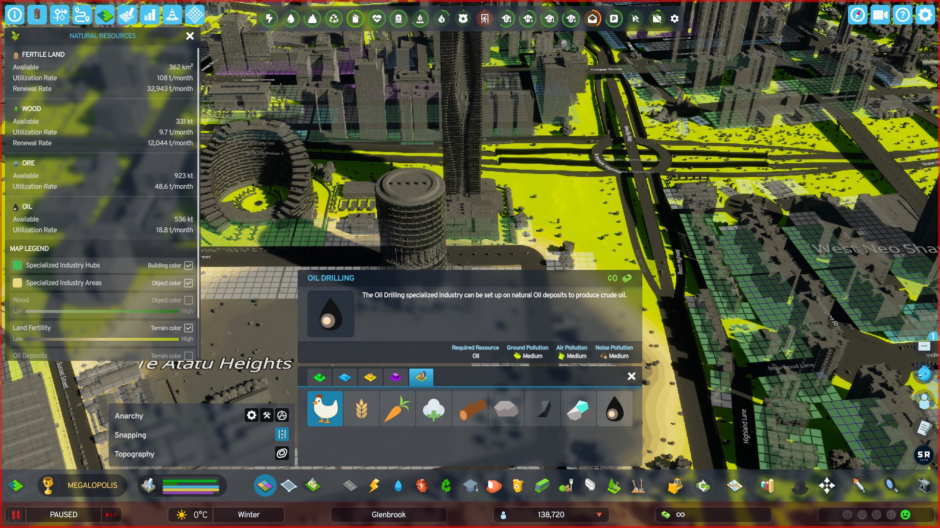
Adopting the zones from the Auckland Unitary Plan, and Cities Skylines 2 could give some examples of Rural Zones melding into the NSZ’s:
- Rural – Production: large scale farming including agriculture, horticulture, viticulture etc. Extractive Industries excluded
- Rural – Mixed: Smaller scale farming, rural service and tourism also enabled. Lifestyle blocks discouraged
- Rural – Extractive: Mining, Quarrying and Forestry. Like Cities Skylines 2 you can overlay what type of extractive industry could apply to that area. This also applies to Forestry
Lifestyle blocks or Rural – Countryside Living could be covered under the Rural Residential zone which is one of the base NSZ’s: Rural residential – low-rise housing up to 500 sq.m. related to agricultural promotion
Rural Conservation Zones would be either the Natural Park Areas or Natural Preservation Areas as seen in the Basic Land-Use Plan.
Future Urban Zones
Japan has a system controlling development on the urban fringe, much like Aotearoa:
Large urban cities within those five points are mandatory to divide the city into two areas, the Urbanization Promoting Area (UPA) and the Urbanisation Control Area (UCA). This method helps the public investments to be more effective, limit Urban sprawl.
Small cities are not mandatory to divide the area but called the Unzoned Area (UA).
The development of the UPA, the UCA, and the UA is to prevent erratic developments in the urban fringe.
Zoning and development is legal anywhere between three areas, but in reality, the majority occurs in the UPA where the process is easiest.
- The Urbanization Promotion Area (UPA) is clarified as an area which already forms urban area and shall be urbanized specifically and systematically within about 10 years. Public facilities such as streets and sewage system are given priority for implementation in the UPA.
- The Urbanisation Control Area (UCA) is clarified as an area which shall be controlled its urbanization. Building plan development in the UCA is not allowed in principle.
- Unzoned Area, for small cities, sometimes referred to as misenbiki areas.
Land deemed Future Urban Zone would if following the Japan system become a UPA to signal urban development. Once the UPA was placed a City Planning Project would kick off:
| Project | Detail |
| Urban Area Development Projects | 1. New Residential Area Development Project 2. Industrial Estate Development Project 3. New City Foundation Management Project 4. Land Planning Arrangement Project 5. Urban Area Redevelopment Project 6. Residential Area Management Project |
| Urban Infrastructure Projects | 1. Infrastructure for Residential Subdivision Developments over 20 Hectares 2. Infrastructure for Government Office Group Areas 3. Distribution Business Districts. 4. Other urban infrastructure |
| Urban Development Projects Scheduling Areas | Early planning area and securing large-scale development and infrastructure area to prevent the speculative investment 1. New Residential Subdivision Development Project Scheduling Area 2. Industrial Estate Development Project Scheduling Area 3. New City Foundation Projects Scheduling Area 4. Over 20-Hectare Area Residential Facility Scheduling Area 5. Public Infrastructure Scheduling Area 6. Distribution Business Scheduling Area |
It should be noted that I am only looking at land use via the Zoning system (that would be covered via the Planning Act, and National Standardised Zones). I am not looking at Spatial Plans, the Building Act nor strictly the proposed Natural Environment Act either. These instruments will have major influence on how the NSZ’s would be crafted and played out in Aotearoa.
Briefly on Urban Design
Urban Design in Japan is ironically managed under their equivalent of the Building Act (the Building Standard Act). That said you would have noticed some tools especially in the Promotion Zones, and Urban Development Projects. These do lean over into the Design aspect. However, even with those tools, Japan will lean into the public realm for design-led placemaking leaving the private realm to their devices providing they follow the base zones, and any overlays or promotion zones that might sit over the top. This is the way Aotearoa should continue as well, and I have written on it in my Placemaking: Public vs Private Realms and the Role of the Planner post!

