
Can the two be reconciled through the Planning Reforms into the proposed Planning Act, and National Standardised Zones?
Recently the Minister for RM Reforms (Planning Reforms) Chris Bishop gave a speech to the Property Council – New Zealand. In that speech he said the following on the Standardised Zones, and Spatial Planning:
The second is greater use of standards. Nationally set standards, including standardised land use zones, will provide significant system benefits and efficiencies.
The new legislation will provide for greater standardisation and ensure that policy setting happens at the national level, while local decision is enabled for the things that matter.
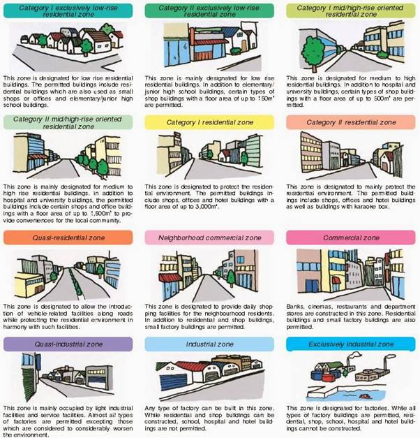
New Zealand does not need 1175 different types of zones. In Japan, which uses standardised planning, they have only 13 zones.
Over time, the construction industry will orientate towards these standardised zones, driving efficiency and lowering cost.
The third big change is spatial planning. Spatial planning done right will enable housing and business development in places where constraints can be avoided or appropriately managed, as well as support early protection of infrastructure corridors and strategic sites, lowering the cost of infrastructure.
It will give you the certainty you need to plan for your long-term development pipelines.
We are carefully working our way through the development of the relevant legislation now, and plan to have two new Acts to replace the RMA in the House by the end of the year. It will become law next year, and councils will begin work on their first plans under the new system after that.
These are the 12 standardised zones from Japan that Bishop is wanting to emulate.
NOTE: There are no Rural Zones nor Open Space Zones under the Land Use Law 1974 for Japan as there are in NZ Planning Documents.
Regarding Rural and Open Space Zones
Rural and Open Spaces are special precincts governed under the law and administered either at Prefecture or National level. So a difference between the two regimes there. That said not hard to introduce what the Auckland Unitary Plan has for Rural as part of the Standardised Zones:
- Rural Production
- Rural Mixed
- Rural Lifestyle (or Countryside)
- Extractive (Mines and Quarries)
Rural Coastal, and Rural Conservation would be Overlays similar to Japan.
More on the Japan Land Use Law and its possible influence on the Aotearoa Standardised Zones:
Indigenous World View on Planning technically does not run up against Standardised Zones in of itself. However, whether you adapt to indigenous planning with a Zone or Precincts I will cover below. The District Plan being used as an example is public information.
Does the Indigenous World View on Planning Run Up Against the Standardised Zones?
The Indigenous World View (this case Maori in Aotearoa, and Aboriginal in Australia) on Planning technically does not run up against Standardised Zones in of itself. Ironically because the Japanese Standardised Zones were borrowed the German planning system (which is also the home of modern post-war Spatial Planning). So already an Eastern Culture has adapted a Western style of Planning into their local context. Ironically for NZ we would be adapting the East into our Western version. Full circle and all that.
Now how do we adapt Maori world view into the Standardised Zones?
First the creation of the Special Purpose Zone (which already exist in our District and Unitary Plans). This Zone would go alongside the other Standardised Zones in the Planning Act, and Standardised Zone system.
Second the NES Papakāinga will give the planning framework that can be adapted into a Special Purpose Zone as part of the NSZs. Below is the opening context to the proposed NES-P that will become part of the Planning Act next year.
Part 3.2: National Environmental Standards for Papakāinga
Context
In recent years, many whānau Māori have become interested in returning to live on ancestral
land in papakāinga. ‘Papakāinga’ can be defined in many ways but is usually understood to
refer to a communal settlement on ancestral land.
Planning rules do not always reflect the needs of Māori land owners who want to develop
multiple dwellings and perhaps some non-residential activities on communal land. This is
especially true in rural zones where plans often permit only one home per lot. Specific
planning provisions are needed to enable papakāinga and provide opportunities to live on
ancestral land.
What problems does the proposal aim to address?
Provision for the development of papakāinga in district plans is variable, if it exists at all. This
restricts the ability of many whānau, trusts and incorporations to develop papakāinga on their
land, and misses opportunities to:
- increase the supply of affordable housing
- enable the development of whenua Māori
- support positive social and economic outcomes.
The relationship between Māori and their culture and traditions that involve ancestral lands,
water, sites, wāhi tapu and other taonga is a matter of national importance under section 6 of
the RMA. The inconsistent provision for papakāinga in district and unitary plans is preventing
Māori land owners from using their land to house their whānau, exercise autonomy over their
whenua and build wealth.
What is the proposal?
The proposal is for new National Environmental Standards for Papakāinga (NES-P). An
overview of this proposal is outlined below, and more detailed proposed provisions are
available in attachment 1.7 of this document.
Example of a Special Purpose Zone
How would the objectives, policies and rules written for the Special Purpose Zone to incorporate NPS Papakāinga? Introducing the Hopuhopu zone from the Waikato District Plan
Hopuhopu will become the headquarters to Waikato-Tainui and the Zone allows for the adaptive use of the land that the normal standardised zones might otherwise miss. The Special Purpose Zone would allow individual tayloring to specific iwi needs up and down Aotearoa. The Hopuhopu Zone is an example.
Special purpose zones
HOPZ – Hopuhopu zone
The relevant district-wide chapter provisions apply in addition to this chapter.
Purpose
The Hopuhopu site comprises 138ha. This land, a former army base, was returned to Waikato-Tainui in 1993 by the Crown. The site is held in Te Wherowhero title for the benefit of all Waikato-Tainui. Waikato-Tainui established a complex including the Waikato-Tainui College for Research and Development (also known as the endowed college) along with residential, administrative, business, sports and other activities. This significant resource has historic, symbolic, and cultural importance to Waikato-Tainui, who wish to develop the land as a tribal hub for the benefit of all their people. Issues for development include limitations on three waters infrastructure and the capacity of the road network.
Objectives
HOPZ-O1 – Purpose of the zone.
Waikato-Tainui are able to promote their spiritual, educational, cultural, social, economic, and environmental interests, well-being, and associations in accordance with tikanga Maaori, in a tribal hub within a place of historic, symbolic, and cultural importance to Waikato-Tainui in the zone.
HOPZ-O2 – Role of Hopuhopu.
The role of Hopuhopu as the headquarters of Waikato-Tainui and the site of the Waikato-Tainui Endowed College is recognised and strengthened.
HOPZ-O3 – Development.
Development of the zone is of a character and scale that reflects its river setting and is compatible with the special nature of Hopuhopu as the headquarters of Waikato-Tainui.
HOPZ-O4 – Use and development.
The use and development of the Hopuhopu site for a range of activities is facilitated and enabled whilst ensuring adverse effects of activities are avoided, remedied, or mitigated.
HOPZ-O5 – Te Wherowhero.
Recognise the special nature of Te Wherowhero title as treaty settlement land which is held for the benefit of all Waikato-Tainui.
HOPZ-O6 – Infrastructure.
Infrastructure to support development is provided in an integrated and comprehensive manner and in place at the time of development.
Policies
All precincts
HOPZ-P1 – Hopuhopu precincts.
- (1): Provide for a range of compatible activity types in appropriate locations by defining specific precincts within the zone, being:
- (a): PREC8 – Hopuhopu residential precinct providing for predominantly residential activities;
- (b): PREC9 – Hopuhopu education and conference precinct providing for predominantly educational and conference facilities
- (c): PREC10 – Hopuhopu business precinct providing for predominantly business activities;
- (d): PREC11 – Hopuhopu open space precinct providing for predominantly open space, used for recreational and rural activities; and
- (e): PREC12 – Hopuhopu mixed use precinct providing for predominantly mixed use activities
You can see the full suite of objectives, policies, and rules with the Hopuhopu Zone here.
Design (and Spatial Form)?
Strictly speaking both design and spatial form despite the Standardised Zones would occur organically adapting to their local geographies rather than more perscriptive forms we might otherwise see.
I cover this in more depth in the following post about placemaking with the public verses private realms.
But in the end this is about blending and adapting worldviews rather than excluding the other.


