
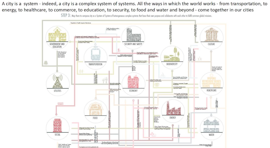
Cities are living organisms
Wondered how your city and/or region works. Wondered what Planners do to enable (that is enable not disable) the ongoing evolution of your city and region that you live, work and play in? Does the Planner Word Salad get you absolutely lost? Don’t worry the word salad gets this planner lost too.
In any case I will be running a six part series using Marsden Point from Cities Skylines 2 to help decipher some of that planning word salad, what planners should be doing as economic enablers, while building a liveable city. Content will be a mix of words, infographics, slide decks, and videos. The content will be using the AI to summarise content drawn from Talking Southern Auckland, and Ben’s Cities blogs.
The City Pulse – How Cities Breathe: The Secret Dance Between Transport and Land Use

Introduction: Your Daily Journey is a City’s Story
Think about how you got around today. Did you walk down a tree-lined street to a bus stop, bike along a dedicated path, or drive from a quiet residential road onto a busy highway? Each of those moments—the design of the street, the location of the bus stop, the existence of that highway—is part of a larger story about how your city is organized. This relationship between how we move and how we live is one of the most powerful forces in urban planning.
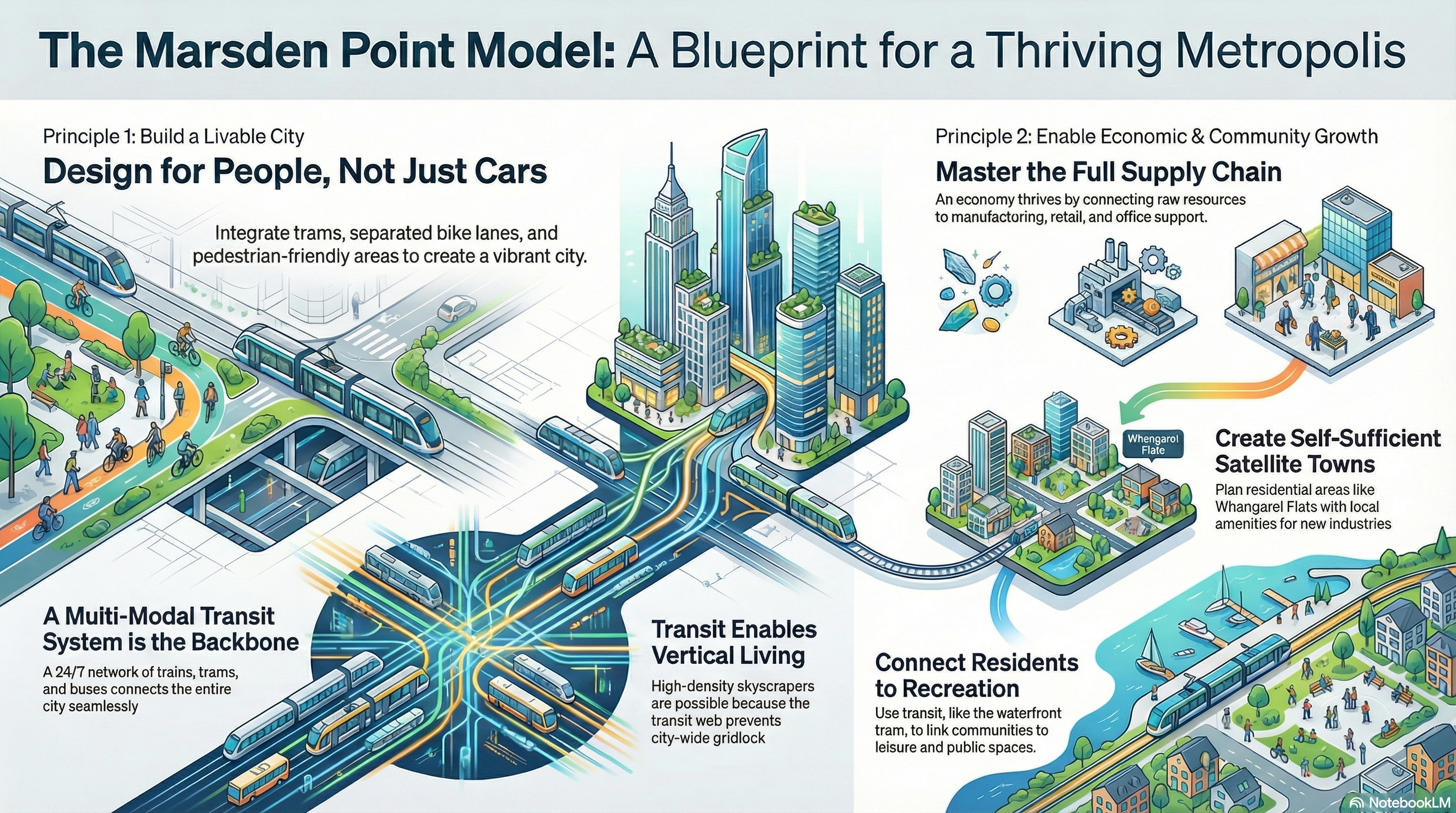
At its heart is a simple, memorable principle: Transport affects Land Use, and Land Use affects Transport. These two elements are locked in a constant dance, each one leading and following the other. But how does this dance work on the streets you travel every day? Let us use the city of Marsden Point as our case study—a city thoughtfully designed around the intricate ways its people move.
1. How Getting Around Shapes Your Neighbourhood (Transport -> Land Use)
First, let us explore how transportation networks function as the skeleton for a city, determining what our neighbourhoods look like and what we can do in them.
1.1. The Lifeline to Quiet Suburbs
Efficient transportation is what makes a quiet suburban lifestyle possible. Take the satellite town of Whangarei Flats in Marsden Point. The streets here are lined with single-family homes, each a unique splash of colour, bordered by vibrant, multi-hued fences. You can see into a tidy backyard where clotheslines catch the morning breeze. This spacious, low-density community is a peaceful place to live, but it is located away from the city’s main economic hubs.
The Trans Marsden Rail and dedicated green bike lanes function as essential lifelines. They connect residents from their front doors to the city’s commercial and industrial centres. Without these efficient transport links, the sprawling residential land use of Whangarei Flats would be impractical for thousands of commuters.
The land use—these sprawling, colourful homes—is only possible because the transport network reaches right to your curb, seamlessly connecting the first mile to the main line.
1.2. The Foundation for a Towering Skyline
Just as rail enables suburbs to spread out, high-capacity public transit allows a city centre to build up. The City Centre of Marsden Point is a perfect example, with a towering skyline dominated by skyscrapers like Grand View Heights and the tower locals call the “‘big silver dragon,'” which can house tens of thousands of people.
This is a textbook example of how high-capacity transit enables vertical density. This incredible concentration of people is only sustainable because of a complex transit web of trams, a metro running underneath the city, and regional rail lines. This system is the foundation for the skyline. Without its ability to efficiently move “LOTS OF People,” the city centre would halt, choked by impossible levels of car traffic.
- Moving the Masses: The transit system allows tens of thousands of people to get to and from the city centre efficiently.
- Enabling Vertical Growth: Because people do not need to rely on cars, the city can build upwards, creating a dense, vertical skyline.
1.3. Building a Destination for Fun
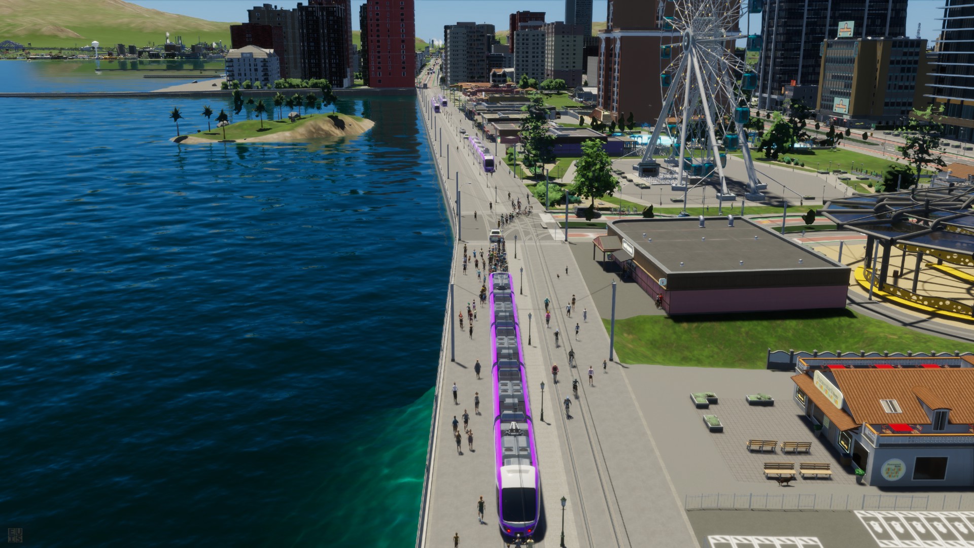
Transportation can also be intentionally designed to create and support recreational areas. The Marsden Point waterfront is a vibrant hub for leisure, featuring a large Ferris wheel, public promenades, and outdoor cafes where families and friends gather.
The key to its success is access. The tram line across the Marsden Bay bridge is not just a commuter route; it is a vital link specifically designed to bring people to these attractions. This deliberate planning decision shapes the waterfront’s land use, transforming it from a simple shoreline into a joyful and accessible public space for everyone.
Thus, the transportation network acts as the primary tool planners use to intentionally shape land use, dictating whether a neighbourhood spreads out in quiet comfort, rises to a dense commercial peak, or opens into a welcoming public space.
2. How Neighbourhoods Shape the Way We Move (Land Use -> Transport)
Now let us look at the other side of the coin: how the design of our neighbourhoods dictates the kind of transportation systems we need.
2.1. Why the City Centre is Full of Trams and Trains
When you arrive at Marsden Central Station, you experience an “exhilarating surge of energy.” The platform is a chaotic but controlled flow of people, punctuated by the chime of a departing tram on the street above and the deep, distant rumble of the metro running beneath. This is because the city centre is a dense concentration of jobs, homes, and attractions.
This high-density land use does not just create a demand for high-capacity transportation; it is a mathematical necessity. A city cannot concentrate tens of thousands of jobs and homes in one square mile and expect private cars to service it—the resulting gridlock would paralyze the city. The dense land use forces the adoption of an efficient, multi-modal transit system featuring trams, a metro, and regional rail services to manage the sheer volume of people.
2.2. The Commuter’s Path
The daily journey for many residents begins in a residential area like Whangarei Flats or Hurston Yards and ends in the city centre or in one of the purpose-built industrial parks with their factories and processing plants. This physical separation of different land uses—places to live versus places to work—creates the need for specific transport links.
This land use pattern, where home and work are in different zones, necessitates commuter transport options. The Trans Marsden Rail exists precisely to bridge this distance, allowing residents to bypass the “highway blues” and connect these separate parts of the city into a functional whole.
Just as transport shapes the land, the land’s purpose sends signals back, demanding specific ways for people to move.
3. The Feedback Loop: A City in Constant Motion

As we have seen, this is not a one-way street. Transportation and land use are locked in a continuous cycle where they constantly influence each other. Planners call this The Feedback Loop. One decision reinforces the other, creating the city’s character over time.
This cycle is clearly visible in Marsden Point:
| If We Build This TRANSPORT… | …It ENCOURAGES This LAND USE |
| A commuter rail line (Trans Marsden Rail) to the suburbs. | Sprawling, low-density residential areas (Whangarei Flats). |
| A high-capacity tram and metro system in the core. | A dense, vertical city centre with skyscrapers. |
| A scenic tram line across the bay (Marsden Bay). | A vibrant, accessible waterfront for recreation. |
| And If We Plan This LAND USE… | …It REQUIRES This TRANSPORT |
| A dense downtown with thousands of residents and jobs. | A multi-modal transit hub (Marsden Central Station). |
| Separate residential suburbs far from the city centre. | Reliable commuter options to connect home and work. |
Smart, liveable cities are the ones that understand and actively manage this powerful feedback loop to achieve their goals.
4. The Big Picture: Why This Matters to You
Understanding this planning principle is not just an academic exercise. The dynamic relationship between transport and land use directly impacts the quality of life for every single person in a city. For a resident of Marsden Point, the benefits of this thoughtful integration are clear.
- A People-Focused City. By integrating trams, buses, protected green bike lanes, and wide sidewalks, the city is designed for “people, not just cars.” This design philosophy explicitly implements a key principle of modern urbanism, often summarized as ‘Design for People, Not Just Cars,’ creating a vibrant public realm. This creates a more pleasant, less stressful environment where moving around is a part of the experience, not a chore.
- Freedom and Accessibility. Marsden Point offers “fully funded 24/7 transit services.” This means residents have the freedom to work late, meet a friend arriving on a midnight train, or simply explore the city lights without worrying about how they will get home. The “Midnight Rendezvous” made possible by the tram line is a perfect example of how reliable transit provides true accessibility at any hour.
- A Vibrant and Interesting Place. The result of this thoughtful planning is a city with distinct, lively character. There are quiet suburbs for family life, a bustling downtown for commerce and culture, and a joyful waterfront for recreation. This dynamic character is even punctuated by unique city-wide events, like the recurring rocket launches that can be seen from all over the bay, adding a sense of wonder to daily life.
Conclusion: Two Sides of the Same Coin
The relationship between how we move and where we live is fundamental to the character of any city. The core principle is a loop that never ends Transport affects Land Use, Land Use affects Transport.
The way a city moves and the way a city lives are not separate things. They are two sides of the same coin and understanding this is the first step to imagining and building better, more liveable cities for everyone.
Marsden City, the City with a Pulse.
See economic development, and the experience of the transport system. Note: AI generated from Talking Southern Auckland, and Ben’s Cities Blogs
The Marsden Point Playbook: Building a People-First Metropolis
AI generated slide deck on building that people first metropolis that actually has a pulse!

