Could the unapologetic language finally deliver the KISS we are looking for while in Planning while still enabling quality of life?
With the Select Committee Report for the Planning Bill out sometime next week (24th June, 2026 is the indicative date), we will get a better look at where things might end up for the Planning Regime. Naturally the Bill still needs to go through Second Reading, the Committee of the Whole House where amendments can be filed and voted on (and a possible filibuster by the Greens could occur here) before the Third (and final) Reading takes place allowing the Planning Bill to become the Planning Act.
In parallel to all this there has been a lot of movement in the AI/LLM space internationally (not so much domestically due to our status-quo mentalities and gatekeeping mindsets) with the equivalent of our Consent Planning, and Policy (Land Use) Planning. For the sake of clarity I will focus on the Policy and Spatial spheres of New Zealand Planning as there is where my wheelhouse is. If something critical with AI and Consent Planning arises I might cover it separately. So let’s take a look to see if and how AI might work in the Policy and Spatial Planning spaces.
Using AI to create the framework for a Combined Plan under the Planning Bill.
Under Parts 2, 3, and Schedule 2 of the Planning Bill, and in combination with the National Policy Statements, and National Environment Statements; Councils in Aotearoa are required to produced Combined Plans. Combined Plans are a single document where the Spatial Plan, Regional Plans under the Regional Policy Statement, and District Plans (or for Unitary Authorities like Auckland, the Spatial and Unitary Plans) are combined into one big planning document. All plans in the Combined Plans must give effect to the Spatial Plan while the Combined Plan itself must adhere to the National Directions under the NPS and NES’s.
What I have done is use the AI, and what we know about the Planning Bill thus far to create a framework for a Combined Plan for Auckland otherwise known as the Auckland Regional Combined Plan. Now where are a few assumptions to be made here:
- I am only touching three parts of the Planning Bill, and three of the NPS’s. There are other sections and other NPS/NES’s that will need to be factored. But for brevity and initial concept testing I used the respective sections from the Bill, the NPS-Urban Development, Infrastructure, and Natural Hazards as that is where most interactions are likely to take place with the Combined Plan, subsequent Consent and Permits under Part 5 of the Planning Bill, and interfacing with the public under this proposed regime.
- The Standardised Zones are not known yet and will not be known until either the end of 2026 or early 2027 as the Ministry is still drafting them. Consequently I have used my hybrid Japan/NZ Standardised Zones for the AI tests.
- For the Maps, GIS software needs to be used. The AI did write the GIS codes for the maps following my Standardised Zones so they can be used for test purposes.
- MOST OF ALL: this is a concept, NOT OFFICIAL POLICY. I like to play around with things to see if their applications are viable in real world environments.
So with that lets dive right in to this Auckland Regional Combined Plan
The Auckland Regional Combined Plan Concept using AI/LLM’s
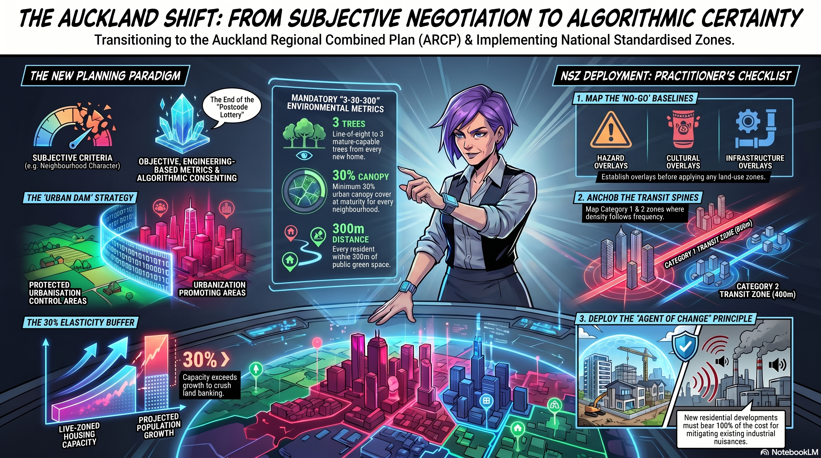
Welcome to our deep dive into the future of New Zealand’s urban development. Today, we are introducing the Auckland Regional Combined Plan and its accompanying briefing document, which serves as a comprehensive practitioner’s manual and professional simulation. This framework represents a massive paradigm shift in how we build our cities, permanently moving away from the subjective, litigation-heavy processes of the legacy Resource Management Act (RMA).
Crucially, the Auckland Regional Combined Plan acts as a live testing ground for the concepts introduced in the Planning Bill (Planning Act 2026) and the Natural Environment Act 2026. The briefing document explores how to implement the Planning Bill’s strict, measurable statutory goals—such as radically unlocking housing capacity, enabling primary sector growth, and deploying resilient infrastructure—without getting bogged down in local political negotiation.
To deliver these ambitious legislative outcomes, the Plan replaces human subjectivity with a mathematical “Culture of Adherence,” heavily driven by AI and digital technology. Here is how artificial intelligence and algorithmic systems interact to execute the Planning Bill’s vision:
- Algorithmic Consenting via the “Digital Twin”: The Plan is designed as a digital-first, layered relational database. Developers no longer submit static 2D PDFs; instead, they upload comprehensive 3D Building Information Models (BIM) into the Council’s “Digital Twin” system.
- Real-Time Automated Assessments: Upon upload, the AI algorithm instantaneously cross-references the building model against the strict spatial constraints of the new National Standardised Zones. The system uses cloud computing to test complex mathematical metrics without human intervention, such as calculating winter solstice shading polygons, verifying acoustic insulation decibels, and measuring structural soil volumes.
- Rapid Prototyping: If a design fails the algorithmic test, the AI generates an instant automated API error report (e.g., pinpointing that a roof casts too much shadow at 1:00 PM), allowing architects to rapidly iterate and resubmit their models on the same day.
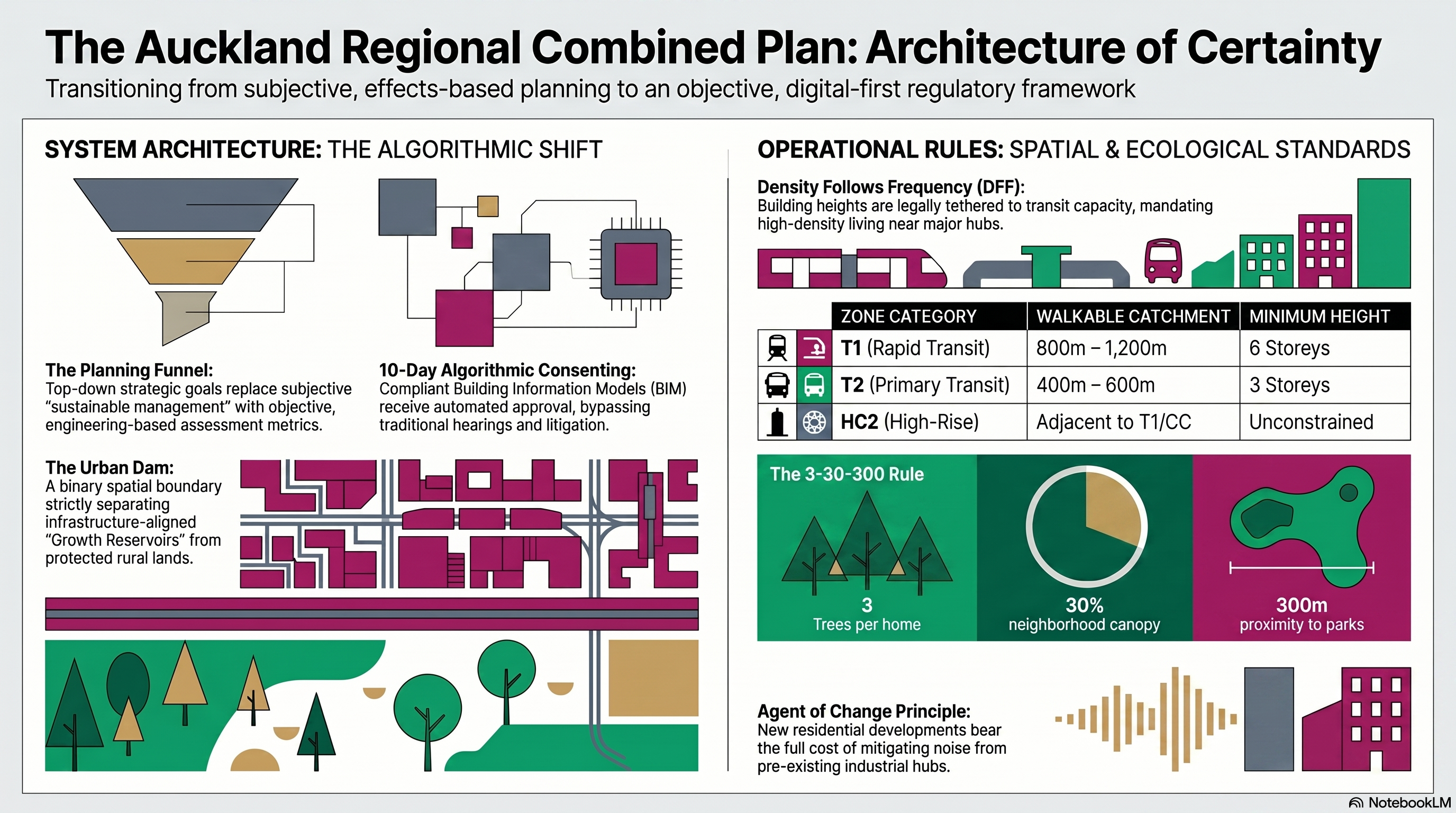
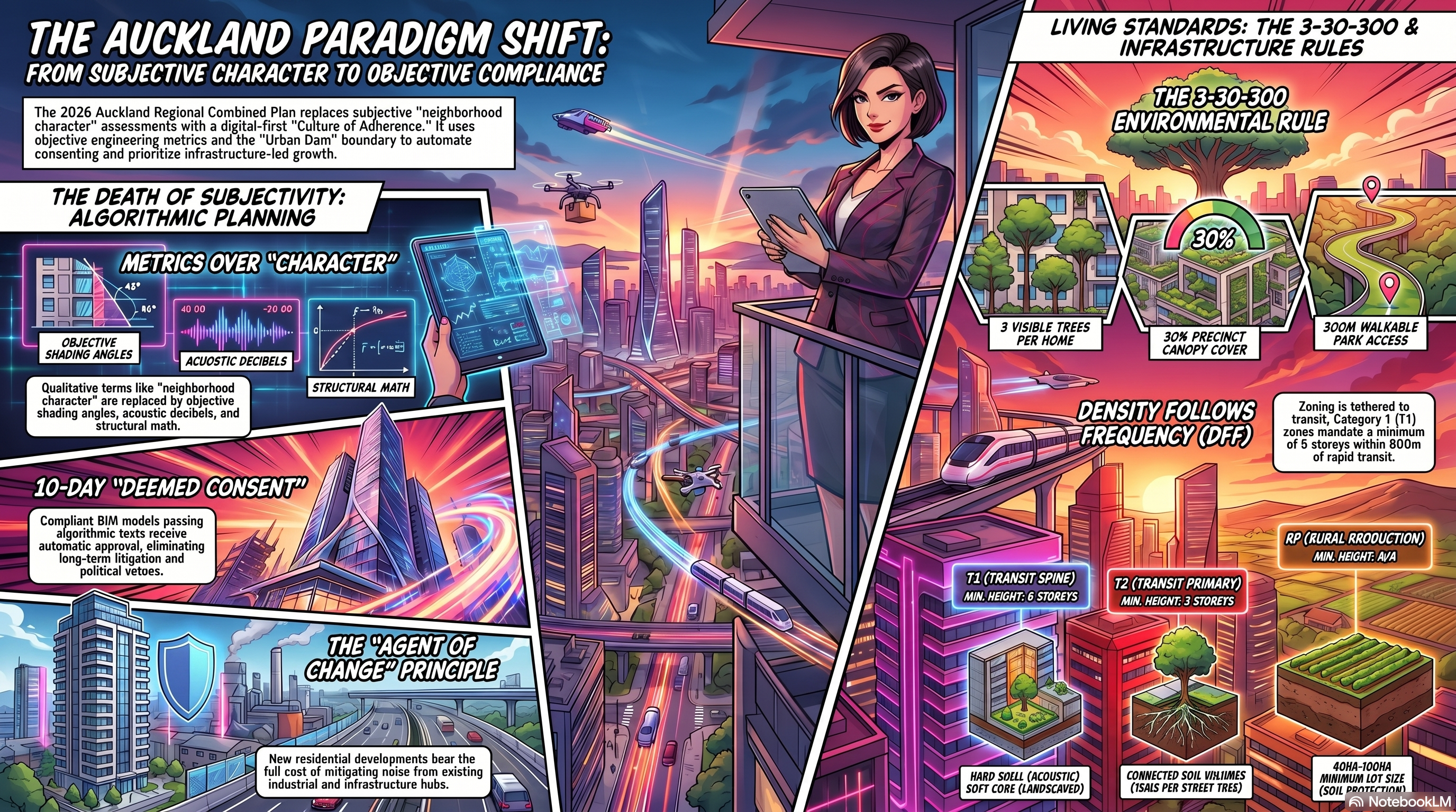
- 10-Day “Deemed Consent”: If the AI’s algorithm confirms that the design mathematically complies with the standardized rules, the project automatically achieves “Permitted Activity” status. Bypassing subjective human review and political interference entirely, the system guarantees a fast-tracked 10-day “Deemed Consent,” drastically accelerating development timelines to meet the Planning Bill’s housing targets.
By integrating algorithmic decision-making, the Auckland Regional Combined Plan demonstrates how digital tools can transform the planning system into a frictionless, predictable “Code of Compliance,” ultimately delivering the rapid urban outcomes required by the new legislative era.
Briefing Document: The Auckland Regional Combined Plan (Statutory Model 4.0)
Executive Summary
The Auckland Regional Combined Plan (the Plan) represents a fundamental paradigm shift in New Zealand’s urban planning and environmental management. Moving away from the “effects-based” subjectivity of the legacy Resource Management Act (RMA), the Plan establishes a “Culture of Adherence” grounded in the Planning Act 2026 and the Natural Environment Act 2026. The framework replaces local negotiation with a top-down, goal-oriented system that prioritizes housing supply, infrastructure resilience, and economic productivity.
Critical Takeaways:
- Algorithmic Consenting: The implementation of a “Digital Twin” system allows for 10-day “Deemed Consent” for developments that mathematically comply with standardized rules.
- The Urban Dam: A binary spatial boundary that concentrates growth within Urbanization Promoting Areas (UPA) while strictly prohibiting sprawl in Urbanization Control Areas (UCA).
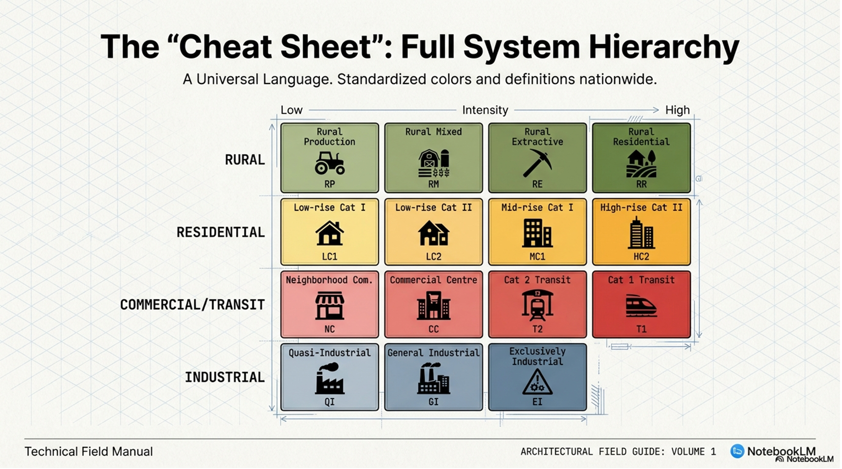
- National Standardised Zones (NSZ): A universal codebase of 17 zones that eliminates bespoke local controls and “postcode lotteries.”
- Infrastructure and Risk Primacy: Development is strictly tethered to infrastructure capacity (Density Follows Frequency) and prohibited in “Very High Risk” natural hazard zones based on a 100-year climate horizon.
- Economic Protection: Absolute protection for industrial and rural production land via “Agent of Change” principles and “Zero Residential Tolerance” in heavy industrial hubs.
The concept document as of June 2026. More tests will be done testing new concepts as more information like updates to the Bill, and the publishing of the Standardised Zones become available.
The Auckland Regional Combined Plan concept, including the Standardised Zones
The Briefing continued
1. The Paradigm Shift: From Negotiation to Adherence
The framework replaces the nebulous concept of “sustainable management” with direct, measurable Statutory Goals: unlocking housing capacity, enabling primary sector growth, and doubling renewable energy output.
1.1 The Planning Funnel and Objective Metrics
Planners are legally required to disregard subjective matters such as visual amenity, trade competition, and private views. The assessment criteria shift from qualitative essays to objective engineering metrics:
- Acoustic Insulation: Measured in decibels (STC ratings).
- Shading Angles: Mathematically calculated via the winter solstice equinox.
- Structural Safety: Based on actuarial risk-based assessments.
1.2 Resolving Conflict Upstream
Unlike the RMA, which left conflicts to be settled at the resource consent stage, this model requires conflicts to be resolved during plan formulation. National goals—such as infrastructure delivery or Tier 1 housing nodes—explicitly prevail over local ecological preferences or neighborhood character.
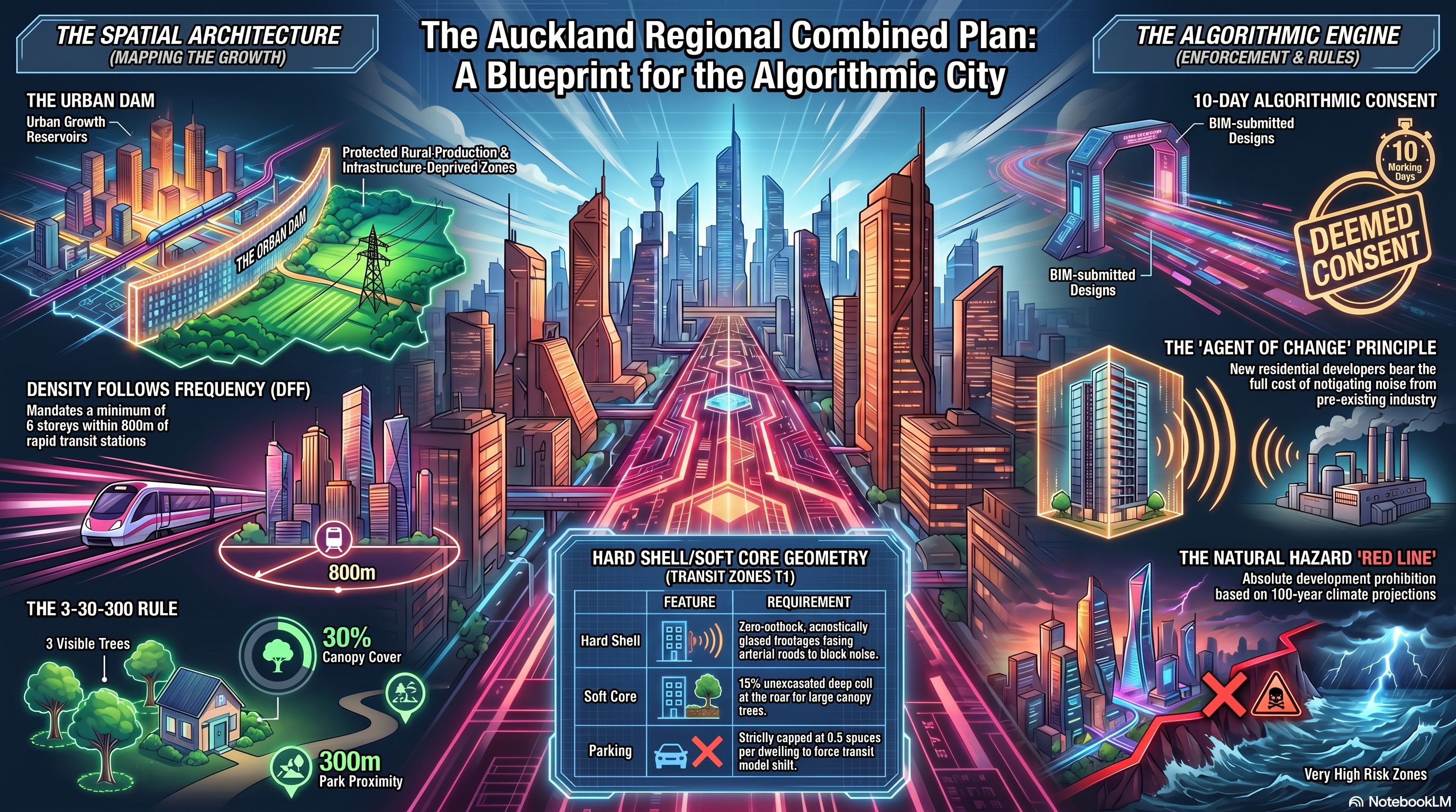
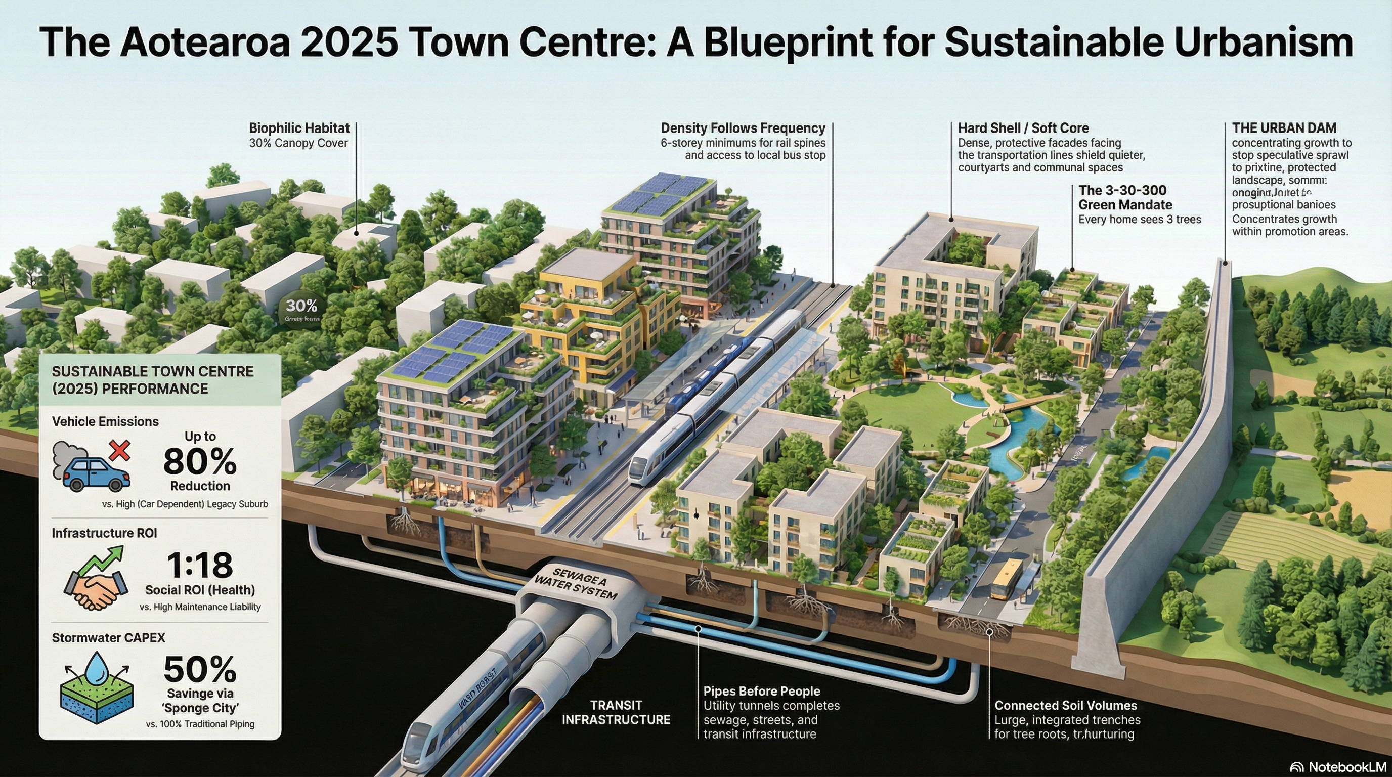
2. Strategic Growth Management: The “Urban Dam”
The Plan establishes the Urban Dam, a legally impenetrable spatial boundary designed to end greenfield sprawl and focus municipal investment.
| Feature | Urbanisation Promoting Areas (UPA) | Urbanisation Control Areas (UCA) |
|---|---|---|
| Definition | Designated “Growth Reservoirs” | The “Dam Walls” Against Sprawl |
| Policy Logic | Infrastructure-first prioritization | Planned infrastructural deprivation |
| Investment | Mandatory CAPEX alignment for utilities | Prohibited urban-scale utility extension |
| Zoning | T1, T2, HC2, MC1 (High/Mid-rise) | RP, RM, RE, RR (Rural) |
2.1 The 30% Elasticity Buffer
The Plan mandates that “live zoned” capacity must exceed projected population growth by a minimum statutory buffer of 30%. If the buffer drops below 29%, Algorithmic Upzoning is automatically triggered across transition buffers without requiring a formal plan change or political review.
3. The National Standardised Zones (NSZ) Rulebook
The NSZ acts as a “Universal Codebase” consisting of 17 distinct categories. Creating bespoke zones or tweaking core parameters results in the loss of legal protection from litigation.
3.1 Transit Spines and Commercial Cores
| Zone | Primary Objective | Key Mandates |
|---|---|---|
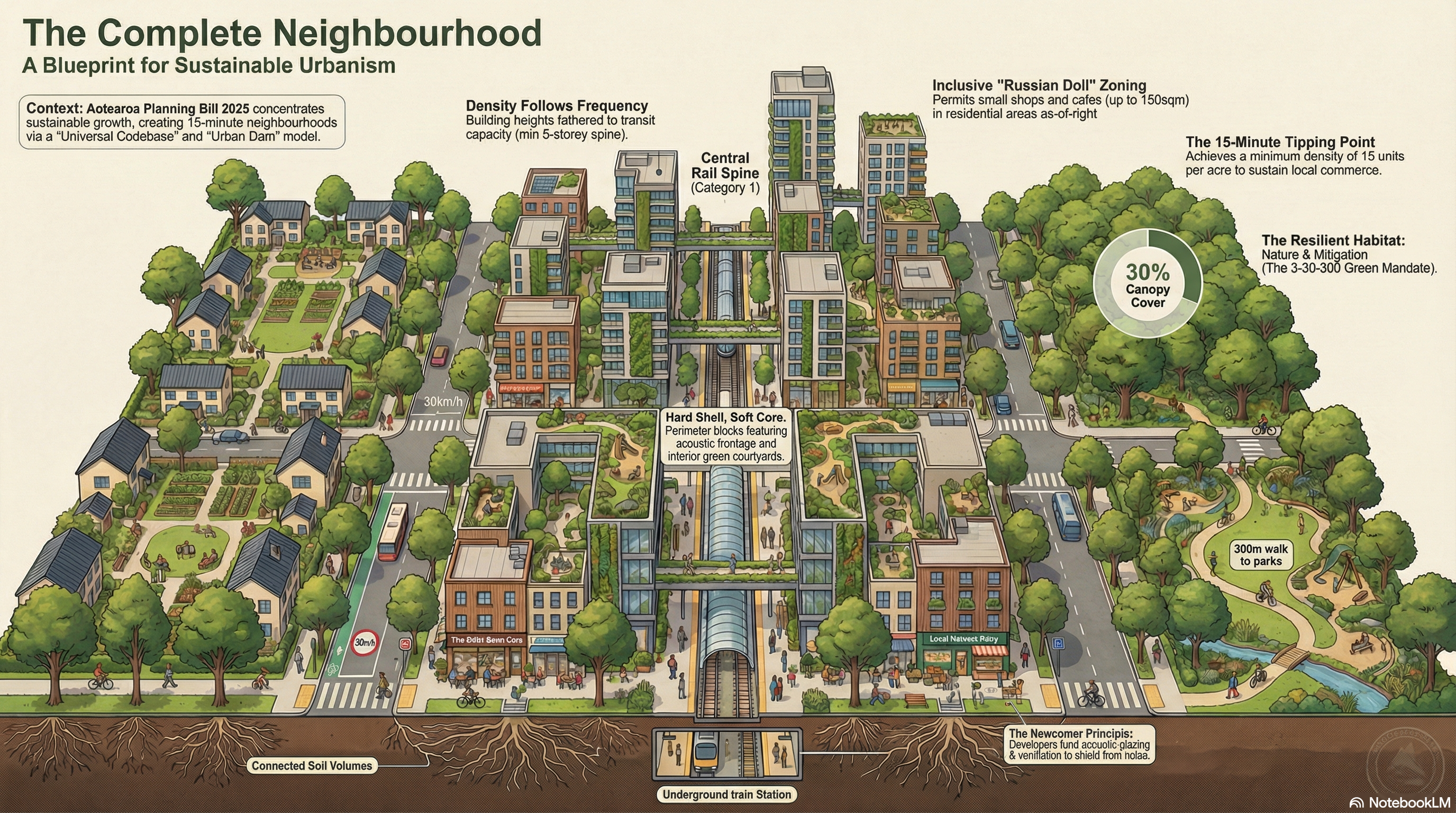
| Category 1 Transit (T1) | Maximize ROI on rapid transit (CRL, Busways). | Min. 6 storeys; Hard Shell/Soft Core design; 800m–1200m catchment. |
| Category 2 Transit (T2) | High-frequency arterial bus routes. | Min. 3 storeys; Connected Soil Volumes; 400m–600m catchment. |
| Commercial Centre (CC) | Large-scale metropolitan employment. | Min. Floor Area Ratio (FAR) of 2.0; Vertical integration; No “big box” sprawl. |
3.2 Residential Tiers: The “Russian Doll” Model
The Plan adopts a “Russian Doll” approach where higher-intensity zones automatically permit activities allowed in lower-intensity zones (e.g., a craft brewery permitted in MC1 is allowed in HC2 by right).
- High-Rise (HC2): Unconstrained height limits (subject to aviation and shading). Includes accelerated 5-day consenting for Build-to-Rent (BTR) models.
- Mid-Rise (MC1): The 3–6 storey “missing middle” workhorse. No front-yard setbacks; maximizes rear-yard green space.
- Low-Rise (LC1/LC2): Temporary holding patterns for areas with infrastructure deficits. Once utilities are upgraded, these zones automatically trigger upzoning to MC1 via API.
4. Key Design and Environmental Mandates
4.1 The 3-30-300 Rule
To ensure public health and mitigate heat islands, all new residential developments must legally guarantee:
- 3 Trees: Line-of-sight from every dwelling to at least three mature trees. Includes a $5,000 “Tree Bond” per specimen.
- 30% Canopy: Neighborhood precincts must achieve 30% urban canopy cover at maturity, audited via LIDAR.
- 300 Meters: Every citizen must live within 300 meters of a public green space.
4.2 Hard Shell / Soft Core Geometry
In high-intensity T1 and CC zones, buildings must adopt a specific layout:
- Hard Shell: Zero-setback, acoustically glazed frontages (STC 55+) to block arterial noise.
- Soft Core: 15% of the site must be unexcavated deep soil at the rear for large canopy trees and communal “lungs.”
4.3 Agent of Change and Reverse Sensitivity
Industrial land is protected from residential encroachment. New residential developers (the “agents of change”) bear the full cost of acoustic mitigation (triple-glazing, mechanical ventilation). The right of heavy industry (EI Zone) to operate 24/7 with noise and vibration is absolute and immune to nuisance litigation.
5. Risk-Based Natural Hazard Management (NPS-NH)
The “Red Line Policy” replaces historical weather data with forward-looking climate projections (RCP 8.5 scenario) and a 100-year horizon (Year 2126).
- Very High Risk Zones: Development, intensification, and subdivision are strictly prohibited.
- Dynamic Managed Retreat: If a structure in a “Very High Risk” zone suffers damage exceeding 50% of its capital value, rebuilding is prohibited.
- Immediate Legal Effect: Hazard rules have legal effect the moment they are notified, allowing the Council to halt dangerous developments immediately.
6. Technological Integration and Enforcement
6.1 The Digital Twin and BIM
The Plan is a digital-first document. Developers submit Building Information Models (BIM) in IFC 4.3 format. The “Digital Twin” algorithm cross-references these models against spatial constraints (shading, height, soil volumes).
- 10-Day Mandate: Compliant designs must receive consent within 10 working days.
- Deemed Consent: Failure by the Council to process a compliant application within the window results in an automatic “Deemed Consent.”
- Financial Penalties: Councils must pay interest (OCR + 5%) to developers for delays in processing compliant builds.
6.2 Infrastructure Alignment (NPS-I)
Parking minimums are abolished region-wide to encourage modal shifts. Infrastructure capacity acts as the absolute trigger for density. Major projects like the Alternative Waitematā Harbour Crossing utilize “Plan Stop” exemptions to bypass statutory freezes and secure land designations immediately.
7. Geographical Case Study Applications
| Case Study | Zone/Mechanism | Outcome |
|---|---|---|
| Te Waihorotiu (CBD) | T1 / CC | Zero height limits; Zero-emission pedestrian zones; 24/7 mixed-use. |
| Mt Eden (Maungawhau) | T1 | Eradication of “Special Character” villas in favor of 6-storey perimeter blocks. |
| Wiri & Airport | Exclusively Industrial (EI) | Absolute zero residential tolerance; absolute right to 24/7 noise/light. |
| Pukekohe | Rural Production (RP) | 40ha minimum lot size to protect elite Class 1 soils; “no-complaints” covenants. |
| Muriwai/Whangaparāoa | Significant Hazard | Halted development; No ratepayer-funded seawalls for private assets. |
| Kumeū/Huapai | Dam Spillway | Transition from UCA to UPA triggered by funded rapid transit; floodplain protection. |
Summary of the Auckland Regional Combined Plan concept