What Percentage is Our Land Used For
I sent a question to Auckland Council on what proportion of our land was used in what per Unitary Plan definitions. After the council geo-spatial specialists crunched some numbers this is what was sent back to me:
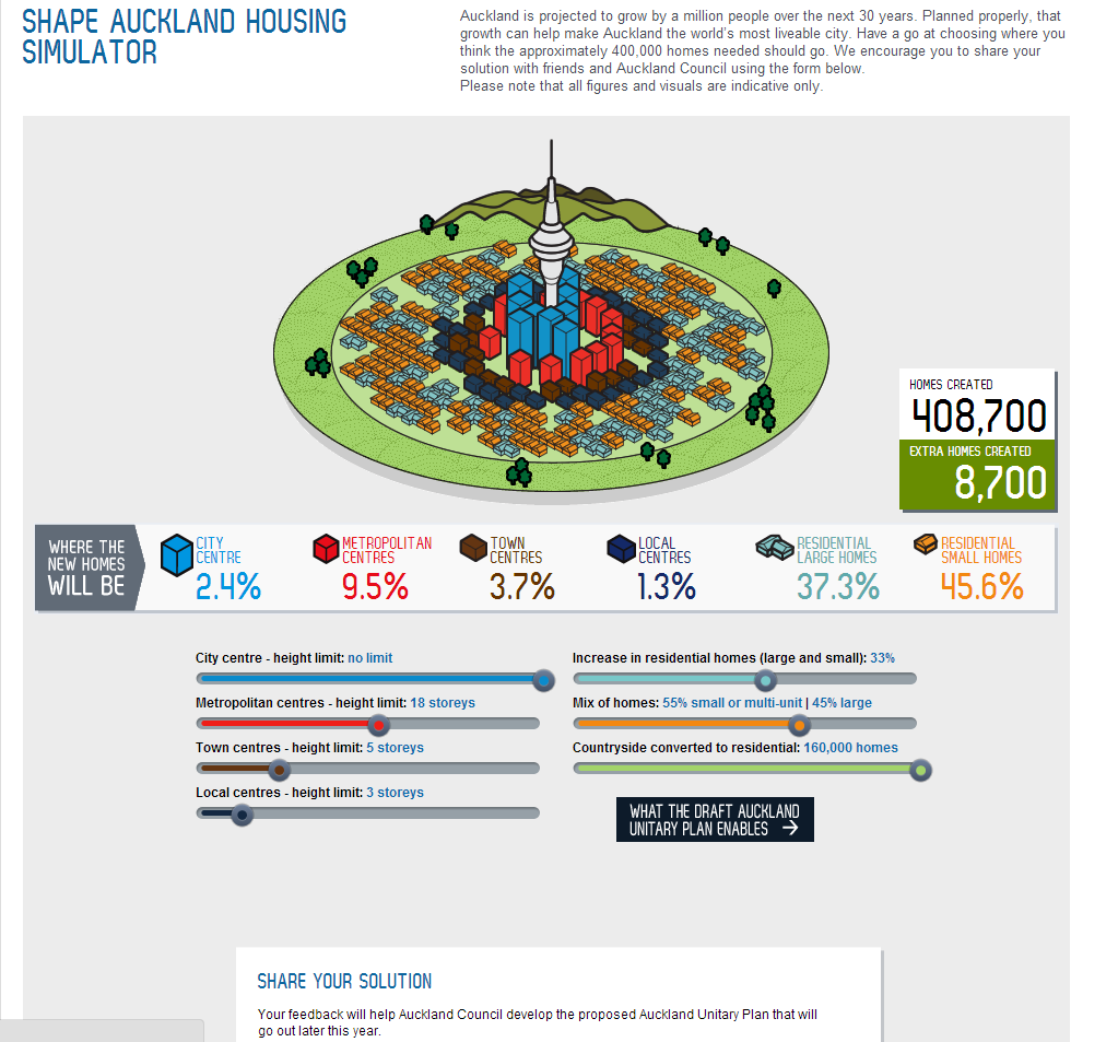
From Shape Auckland (shapeauckland.co.nz)
Our Geospatial specialists have looked into this for you. I’ve included the breakdown of all the zones since it makes quite interesting reading.
Unitary Plan Zone (%)
- Single House 2.89
- Mixed Housing 3.52
- Terrace Housing and Apartment Building 0.49
- Large lot 0.77
- Rural and Coastal Settlement 0.39
- Neighbourhood Centre 0.03
- Local Centre 0.04
- Town Centre 0.09
- Metropolitan Centre 0.08
- City Centre 0.11
- Mixed Use 0.20
- Business Park 0.02
- General Business 0.05
- Light Industry 0.94
- Heavy Industry 0.37
- Rural Coastal 16.66
- Rural Conservation 2.52
- Rural Production 47.41
- Mixed Rural 1.79
- Countryside Living 5.84
- Marina 0.04
- Minor Port 0.01
- Mooring 0.30
- Public Open Space – Conservation 7.24
- Public Open Space – Informal Recreation 1.76
- Public Open Space – Civic & Community 0.02
- Public Open Space – Sport & Active Recreation 0.64
- Special Purpose 1.08
- Future Urban 0.28
- Strategic Transport Corridor 0.59
- Road 3.84
A thank you and appreciation to Auckland Council and their geo-spatial specialists for compiling that data. And yes it does make for an interesting read, especially when road dwarfs out quite a bit of the individual urban zones.
I shall tell a look at these numbers some more and ponder over them but for the most part, well over of 60% of our land is not urbanised.