
Introducing the CFN 2.0
South benefits highly
Earlier today the team at Greater Auckland (formally Transport Blog) released their Congestion Free Network 2.0, a major evolution change to their Congestion Free Network 1.0 released back in 2013. Since 2013 parts of the Congestion Free Network 1.0 were adopted by both Auckland Council and Central Government. CFN 1.0 has been the platform to advocate and progress a more people orientated transport system rather than the car-centric system Auckland has had since the mid 1950’s. Of course we still have a very roads-first Central Government as the East West Connections saga would attest to but to be fair they are slowly (rather glacially) moving towards more progressive transport such as confirming their share of the City Rail Link, and the first version of the Urban Cycleway Network.
Since CFN 1.0 the Unitary Plan has gone live (as of November 2016) and the Auckland Transport Alignment Project (ATAP) sits in the mix. To add a spanner to the mix the Auckland Plan is under refresh right now and I am willing to wager that Auckland Plan 1.5 will be rather different to Auckland Plan 1.0. All this has meant time was due on a Congestion Free Network 2.0.
And here it is for downloading: Greater Auckland Congestion Free Network 2.0
Congestion Free Network 2.0
The context
To quote the beginning of the CFN 2.0
Auckland is a rapidly growing city, situated on a narrow isthmus with constrained corridors. Over the coming decades, Auckland will continue to be New Zealand’s fastest growing region and will account for three-fifths of the country’s population growth between 2013 and 2043. From an estimated population of 1.5 million in 2014, Auckland is projected to reach 2 million in the early 2030s. That means out of every 100 people in New Zealand, 34 people currently live in Auckland, and this will increase to 37 in 2028 and 40 in 20431. (Fig. 1) Auckland’s sheer scale of growth is huge when compared to other parts of the country, growing as much as the entire population (including future growth) of Canterbury over the next 30 years. (Fig. 2)
…….
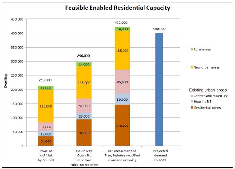
In response to this growth, Auckland Council’s Unitary Plan enables around 422,000 dwellings of “feasible capacity” to meet future growth. Around two-thirds of this development is expected to occur in existing urban areas and the remaining third either in new urban or rural areas. (Fig. 5) Future growth in existing urban areas is not spread evenly across Auckland, while growth in new urban centres is proposed to be mainly concentrated in the north, the north-west, and the south. This growth will be a major driver of Auckland’s future transport needs, while it is also crucial we use transport to drive the shape of Auckland’s future urban form. Let’s not repeat the mistakes of the past where areas like Pakuranga and Botany were developed with no quality transport options. Unfortunately, the different parts of Auckland have very different socioeconomic conditions, with areas in the Northwest/South/ West/Southwest ranking high on the economic depravity index, while Central, North & East rank low. (Fig. 6)

……
WHAT DOES THIS ALL MEAN?
In short, Auckland is a fast-growing city with extremely constrained ability to add more major road corridors as we have now used up long protected routes. We have bet big on a one size fits all model when a best practice network uses the right tool/mode for the right job. Because of this, our reliance on cars is becoming increasingly impossible to continue, and roading projects are becoming increasingly expensive, whether tunnelled (like the Waterview Connection) or not (like the East-West Link). The reality of the issues of a one size fits all model was even noted in the
famous 1960s De Leuw Cather report which proposed many of the motorways we later built, however, while many of the roading projects were completed, the complimentary rapid transit network was not. Yet we need to find a way of transporting more people as Auckland grows, a major challenge that has eluded us for decades.
……
Source and graphics: Greater Auckland Congestion Free Network 2.0
Enter the Congestion Free Network 2.0
The objectives of CFN 2.0
- Connecting Aucklanders to major employment and social centre’s, including the city centre, growing metropolitan centres, and the Airport.
- Prioritising accessibility in areas that are seeing major (population) growth, including both greenfield areas and existing urban areas.
- To provide for the movement of people while balancing place making, the environment, safety, & health.
- Ensure value for money by optimising investments to the local context; this may be mean a rail line in one place and a painted bus lane in another.
- Ensuring equitable transport options throughout the city, especially to low-income areas where people have historically lacked transportation choices.
- To provide a quality transport network for all transportation needs & users, thinking beyond just the traditional commute, an 8-80 network.
- To provide congestion free alternatives, using of spatially efficient transportation modes to maximise people travelling free of congestion, as well as the capacity of the network.
…….
Source: Greater Auckland Congestion Free Network 2.0
The first objective is the main objective that all over objectives sit under. This is excellent as our current planning processes through the Auckland Plan, Unitary Plan, and the Regional Land Transport Program are ad-hock given they are City Centre centric and everything radiates out from there. However, as this blog has illustrated over the years and as Panuku Development Auckland have picked up with Transform Manukau Auckland develops in a diverse manner set by three distinct sub-regions. Those sub-regions being:
- Isthmus and West Auckland
- North Shore and Rodney
- Southern Auckland including Howick and Pukekohe
Each sub-region is unique in its residential, employment, economic output and transport patterns all requiring a heterogeneous (rather than homogeneous) approach.

Source: Panuku Development Auckland
The Congestion Free Network 2.0 strengthens the transit links between the three sub-regions while also strengthening transit within the respective sub-regions as well (the Busway or Airport Light Rail from the Airport to Botany via Puhinui and Manukau is an example of a transit link doing both).
And so here it is the Congestion Free Network 2.0
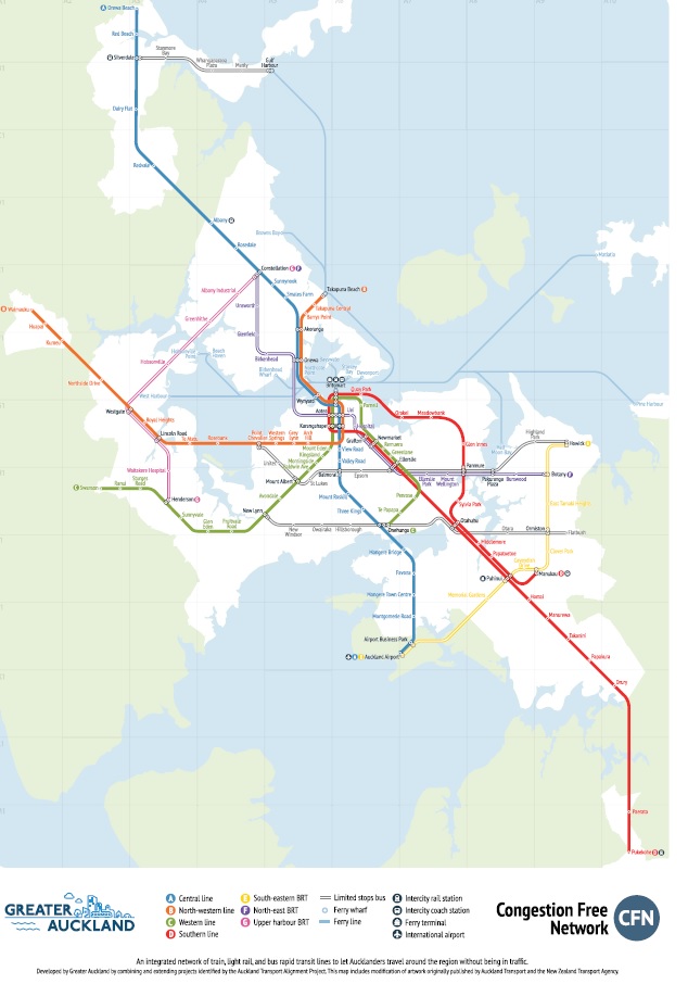
Source: Greater Auckland
If you would like a larger resolution of CFN 2.0 you can see it in the main document linked in this post.
Congestion Free Network – South Auckland
SOUTH AUCKLAND SITUATION
The South is a vital and growing part of our city; high quality public transport is integral to linking these large residential areas with employment and education centres throughout the region. The South will be host to large future housing growth in both existing sectors such as Otahuhu, Papakura, & Manukau, as well as new suburbs around Drury & Pukekohe. The two maps below show the South, on the left, are places such as Otahuhu, Wiri, Manukau, Papakura & Takinini, etc. while on the right are Drury & Pukekohe. It is vital the existing rail services through these areas are expanded to serve these new and expanded communities if they are to prosper. “5,300 hectares of land identified for urban development. This could result in 42,000 homes and 19,000 jobs over 30 years (note from admin: full yield is 55,000 homes and 35,000 jobs). The decision version of the Unitary Plan provides for greater capacity should this be required.”13 The South sadly also scores very high in the 2013 deprivation index and improved and affordable access to employment and education is an important tool in the fight against deprivation and inequality.
The Eastern/Southern Rail Lines currently service the South, the CRL will improve journey times by removing the Western Line dead stop at Newmarket, as well as allowing a bypass of the slow Newmarket Branch Line, access to Up/Midtown will improve because of the CRL. The main objective for us was to maximise this asset & the building of the CRL, as well as a new RTN connecting the East, the South, and the Southwest/Airport areas.
……
Source: Greater Auckland Congestion Free Network 2.0
This is what the South sector of the Congestion Free Network 2.0 looks like:

Southern Auckland
Source: Greater Auckland
It should be noted that the Congestion Free Network 2.0 is about forming transit spines within a sub-region area or connecting different sub-region areas up. The CFN 2.0 does not show Frequent Transit Network routes such as the Great South Road 33 bus, and the 31 and 32 services in the Southern Auckland area. It also should be noted that Manukau, Otahuhu and later Botany form major transport interchanges where both Frequent Transit Network busses and local feeder busses connect up with the Rapid Transit Network spines mapped in the CFN 2.0. Currently Manukau serves as the nexus point for most if not all South Auckland busses that radiate from the soon to be completed bus station. Otahuhu is also a nexus point but at a smaller scale to Manukau.
Looking at what CFN 2.0 is trying to achieve with the South:
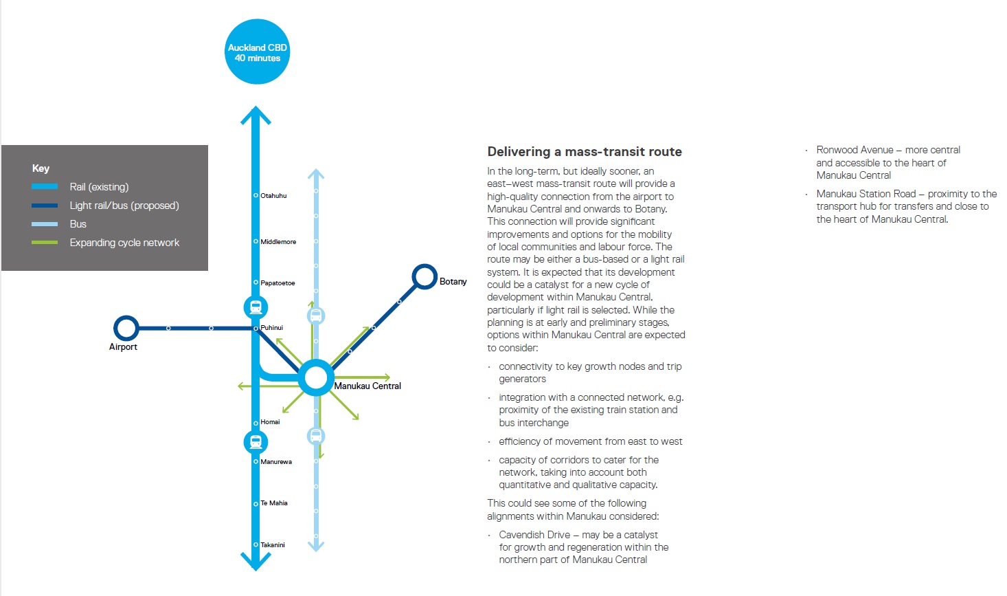
RTN CONNECTING THE EAST, THE SOUTH, AND THE SOUTHWEST/AIRPORT AREAS.
An integral part of the strategy is a new Rapid Transit connection between Howick-Botany-Manukau-Airport/Airport Employment area. The likely passenger demand and available route suggest that Bus Rapid Transit is the most appropriate system for this route immediately, with the potential for an upgrade to Light Rail in the future once ridership grows. The route, however, would be future proofed fully for Light Rail, and if extra funding came available for Light Rail, or the need became apparent we would be completely open to Light Rail.
The reason Light Rail is imperative on other lines is due to city centre bus capacity constraints, due to large volumes of buses due to converging routes; this route does not have this issue. Another reason is that it leaves space for a heavy rail corridor in the future if Transport Planners wish to connect any potential Intercity Rail to Auckland Airport, while this is outside the scope of the CFN 2.0, it has been mentioned, and we believe we should not prevent future governments from this choice.
INTERCITY RAIL & EXTENSION SOUTH
Intercity rail sits outside the scope of the CFN 2.0. However, rail network upgrades in the south, especially additional track, as well as the completion of the City Rail Link freeing up platforms at Britomart, makes Auckland ready for any future intercity rail service. Such services from Hamilton and Tauranga could also stop at Puhinui for access to the Airport via the new South-Eastern Rapid Transit Line. The intercity service would be able to express past the other southern stations/services using the third/fourth main. Building stations into the Northern Waikato are also
beyond scope. However the CFN is open to a diesel shuttle between Pukekohe & further south, or if the electrification is extended extending Southern services to these areas.
SOUTH AUCKLAND CONCLUSION
The combination of these two major modes Network creates a North-South, as well as an East-West spine for the South. These routes supported by the complementary New Bus Network creates a reliable public transport network for the south, connecting jobs, homes, and community. The routes are focused on supporting proposed greenfield and brownfield development and aiding a region that reports higher levels of deprivation.
………
Source: Greater Auckland Congestion Free Network 2.0
The South Benefits from the Congestion Free Network
While the CFN 2.0 misses the Manukau South Rail Link (giving direct services from Papakura and Pukekohe to Manukau without a transfer at what will become a very busy Puhinui Station when the Airport-Manukau Line is operating) the main three spines give both rapid transit connections within Auckland’s largest and fastest growing sub-region and between the South and the rest of Auckland. To me this is major win number one. Major win number two is how the CFN 2.0 marries up with the 31, 32 and the 33 Frequent Transit Network busses that ply Southern Auckland effectively and efficiently at several key points (Manukau, Papatoetoe and Otahuhu). Major win number three is the provision of the Airport-Puhinui-Manukau-Botany line that would start as a Bus Rapid Transit system, evolve to a Light Rail Transit system as demand grows and allow a heavy rail connection either within the area or slightly further north (Otahuhu) for possible inter-city travel to and from the airport. Finally major win number four is the Congestion Free Network 2.0 marrying up with the objects of Transform Manukau.
Source: Panuku Development Auckland
Panuku in Key Move Five (also see: #ourmanukau Key Move 5: Enhancing Community Connectivity. Part 23 of the #TransformManukau Series) outline how Manukau City Centre serves as the nexus point to transit in Southern Auckland much as how Britomart in the City Centre does with transit Auckland-wide. What the Congestion Free Network 2.0 has done is recognised Key Move Five but also added in a cross-town service from New Lynn to Onehunga, Otahuhu, Otara, Ormiston and Flatbush. While this cross-town line does not connect with Manukau directly (as in you would transfer at Otahuhu) the CFN 2.0 does strengthen what Panuku have envisioned with Manukau and its positive consequences that will have to wider Southern Auckland.
Quick Wins
Now we need to get the quick wins on the board as the Congestion Free Network 2.0 have outlined below:
INTERIM LOW HANGING FRUIT
This is a long-term plan. However, a few upgrades could be feasibly be done in the next few years such as
- Northwest Busway between Westgate – Te Atatu (Would be upgraded to Light Rail later as part of full route package)
- Third Main between Westfield & Wiri
- AMETI Panmure – Botany
- Extension of the Electrification to Pukekohe
- The Central Crosstown Rapid Bus Routes
- Bus Improvements on Central Arterial Routes such as Great North Road
- Busway between Manukau & Airport
- Northern Busway Extension to Albany
- Better Lincoln Road Upgrade
These projects would deliver large benefits for small cost within a quick period allowing us to leverage some of the gains of the CFN 2.0 swiftly as the more major projects go through the investigation/business case/NOR/building phases.
……
Source: Greater Auckland Congestion Free Network 2.0
The ones in bold I consider absolute priority one and need to be completed by 2020 at the earliest, 2023 or when the City Rail Link opens at the latest.
Well done to the Greater Auckland team for assembling the Congestion Free Network 2.0 and equally well done with your recent fundraising drive achieving target as well. Congestion Free Network 2.0 will provide the next platform in advocating for a transport system that actually gets Auckland moving!


Northern busway extension to Albany is underway as part of the SH1-WRR interchange project. Estimated construction start according to NZTA is 2018.