
Bringing Auckland into the 21st Century
In writing this I was made aware how things were going in Christchurch and the wider Canterbury region. Needless to say both are not looking very well and there is a real danger Christchurch our second biggest City could plunge into a recession affecting the wider Mainland.
So in writing this the lessons from Hong Kong (and in part Auckland) can be equally applied to Christchurch albeit a smaller scale to match.
Auckland Council owning complexes on transit stations?
First of all a universal rule when it comes to transit and developments and it has to do with catchments. The general rule is:
- 400 metre radius from the station for easy walk up
- 800 metre radius for standard walk u
- 1.5km for feeder busses to a frequent or rapid transit line
- 2km for an e-bike to a stop or station
- Park and rides have unlimited catchment but are best suited when a station has a rural mix as well. That said park and rides add to localised congestion
Translating this to urban developments on the ground:
- Highest density development within 400 metres of the station
- High density development within 800 metres of the station and along the said transit corridor
- Medium density developments on the 1.5km and 2km radii although you could go slightly higher in the immediate vicinity of a bus stop
- Lower density developments beyond the 2km radii
Using the zones and/or height limits:
- Highest density development within 400 metres of the station
- Terraced Housing and Apartment Zone or Mixed Use Zone set to 8 storeys.
- Metropolitan or Town Centre set to their respective maximum height limits (18 or 8 storeys)
- High density development within 800 metres of the station and along the said transit corridor
- Terraced Housing and Apartment Zone or Mixed Use Zone set to 6 storeys
- Metropolitan Centre or Town Centre height still at maximums
- 1.5km for feeder busses to a frequent or rapid transit line or 2km for an e-bike to a stop or station:
- Mixed Housing Urban Zone
- Centres step back to relative heights corresponding with surrounding residential zone
So your highest premium land is within 800 metres of a transit station whether it be rail, bus or both. Where does Council owning complexes like Hong Kong come into this? It comes from Council usually owning the land at or next to the transit station in question, getting best bang for buck from that land, and encouraging both optimal urban outcomes and transit usage maximisation.
Auckland and Christchurch Councils are pressed for cash and are hard up on their debt limits when it comes to funding new or improved infrastructure like stations. Raising Rates is out of the question and Central Government is as reliable as Auckland’s rail network was in the diesel to electrics transition (i.e not very reliable). So how to build something like Manukau Station or even the K Road City Rail Link Station using non conventional funding (debt and Rates)? Cue Council doing mixed developments over or next to said station.
Enter Hong Kong and the MTR!


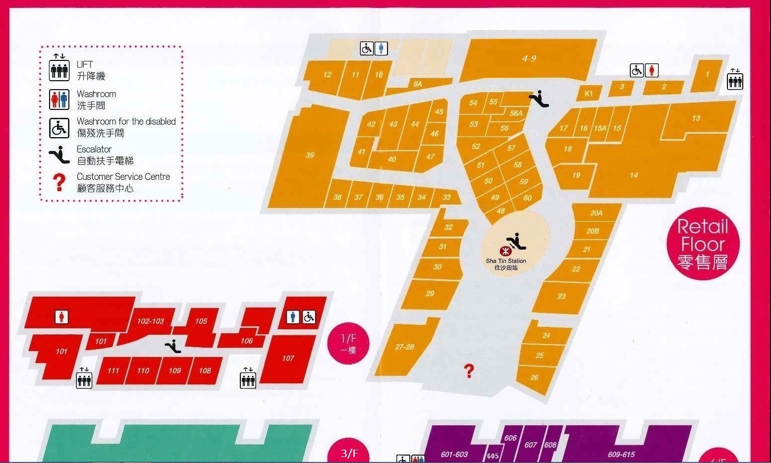
Above is from the MTR Hong Kong and City Link Plaza pages. Long story short MTR owns and operates both the transit stations and the malls that sit above them. This allows Hong Kong to both control urban form above a major transit station while also generating a revenue scheme to fund its transit network. Hong Kong wins from a well patronised and well funded transit system, we win from a well planned transit system and malls right on the station door step as seen in the floor plan above.
The City Centre, Henderson, Manukau and Sylvia Park would be the closest we get to Hong Kong in having major developments on or next to a station (thus within in easy walking distance) currently as well as potential for future development. The current Auckland Council policy of selling their land either inside a Centre or next to a transit station is barking mad when they should be adopting the Hong Kong MTR model of station and urban facility.
Doing this Council can control the urban development outcome while gaining a continued revenue stream to fund both current transit operations and future transit capital expenditure without the reliance on Rates, Central Government or technically debt (that is the debt sits on MTR’s books covered by their commercial assets rather than the Ratepayers books).
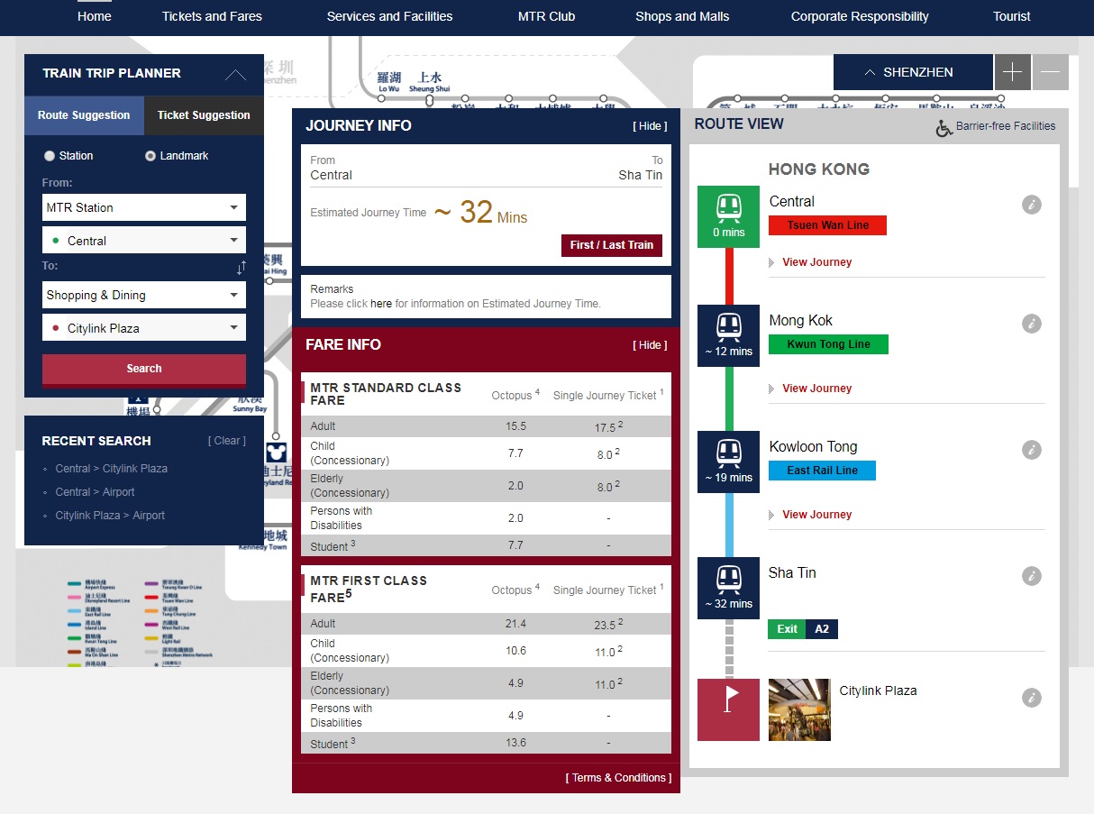
Source: MTR
32 minutes is the same from Britomart to Manukau Station on the Eastern Line. Manukau also hold Auckland’s second biggest mall (in terms of retailers (199 to Sylvia Park’s 207)), fastest growing station in terms of patronage, and a lot of Council held land. So the opportunity is right for some MTR development in Manukau as well as possibly the City Rail Link stations. Have the highest density developments over the top or right next to the station then step back per the radii formula I had given earlier.
All it needs is political will from Auckland Council, something they have not exactly been showing on the issue (which has led partially why the Barrowcliffe Place saga in Manukau continues to fester).


Hi Ben.
Agreed.
But go and have a look at Lincoln Road, the AUP zonings and NOR 54.
For the AUP, the Council planners recommended and put Residential Single lot zoning 2 sections away from Lincoln Road. And next door to Business Mixed Use .They obviously do not know about the 400 m and 800m distances you have mentioned above. Let alone Christaller’s Concentric Ring theory of land economics !!!. SFB !!!
The Planners at the Unitary Plan hearings often left everyone headscratching
Was no consistency