
GPS represents chance to do community and nation building
With the Government Policy Statement on transport out we can see the Government will have Safety and Access as the two high priorities with environment following right behind when it comes to transport investment.
What is Access, Safety, Environment and Value for money?
From the GPS:

Source: NZ Government via Greater Auckland
For the GPS at a glance:
It is the Access strategic direction that warrants the most attention from me as it looks like Twyford is about to engage on some large-scale Urban Geography exercises with that particular direction.
Access is all about: provides increased access to economic and social opportunities, enables transport choice and is resilient.
Primarily:
- addressing projected declines in access to jobs and education, particularly for people living in the west and the south
- accelerating the development of Auckland’s rapid transit network, with a particular focus on routes between the city and the airport, to unlock housing and urban development opportunities
- developing transport connections that are crucial for linking production points with key distribution points (including routes important for exports, and those intra-regional routes critical for getting local goods to market)
And of course:

Source: New Zealand Government
…..
Source: GPS 2018-2021
There are other points in the Access direction that the document goes on about, points that you can read up on about here: Draft-GPS
Effectively where the Government is heading with the GPS is this theme:
Theme: Integrating land use and transport planning and delivery
162. Integrating land use and transport planning and delivery is an important element in creating a transport network that benefits the wider community. Transport is an enabler, connector and shaper of urban areas.
163. Land use planning (including planning new and increased residential or commercial development, improved health or education infrastructure or regional development) has a significant impact on transport policy, infrastructure and services provision, and vice versa. Once development has happened, its impacts on transport are long term. Changes in land use can affect the demand for travel, creating both pressures and opportunities for investment in transport infrastructure and services, or for demand management. Likewise, changes in transport can affect land use.
164. It is essential that land use and transport planning and delivery are coordinated and integrated. This is largely a role for local and central government, supported by funding under GPS 2018.
165. Central government has a role in improving the visibility of planning and infrastructure intentions, facilitating engagement and enabling joint funding and decision-making.
….
Source: Draft-GPS
This would be probably the first time I have seen a very strong policy theme direction on integrated transport/land use planning show up on a central Government document and it can’t fast enough.
Integrated land use/transport planning is Urban Geography in a nutshell. The end goal of Urban Geography is community and nation building.

Source: New Zealand Government
The Transitional Rail Activity (new to the GPS) is an example of Urban Geography, community and nation building to be under taken. The first bullet point does refer to the Third and Fourth Mains on the Southern Line as well as the Southern and Northern Airport Lines. The second bullet point refers to Regional Rapid Rail and the Southern Airport Line working in tandem.

Source: Greater Auckland
Access and integrated land-use/transport planning in the GPS are treating our transport system not as simple roads or rail lines linking from A to B to C (function) but rather a fully integrated system designed to build communities and nations.
Inviting public spaces
71. Creating spaces within the streetscape that are attractive and safe for people to sit, gather and walk and cycle supports the objectives of creating a safer and more accessible network, as well as key outcomes around improving health and well-being.
72. Well designed, attractive public spaces provide residents with places to gather, and attract people to frequent local businesses, connect with their neighbours and partake in recreational and cultural activities.
73. GPS 2018 will support investments that make streets more inviting places for people. This should encourage more housing development in these areas and more city living.
Source: Draft-GPS
I am going to repost my Southern Airport Line community building post here to demonstrate an example of a major transit project that is not just a Light Rail Transit line with some station but also a major community builder for Southern Auckland as well.
I thank Minister Twyford for getting proper integrated planning in place and I look forward to its execution:
The Southern Airport Line – More than a Light Rail Line – A Community and City Builder Too!
A line that also builds communities
This post originally appeared in LinkedIn on February 14: https://www.linkedin.com/pulse/southern-airport-line-more-than-light-rail-ben-ross/
Yesterday I gave a presentation to the Auckland Council Planning Committee on the importance of the Southern Airport Line and why it should be built as soon as possible.
You can see the presentation from the Auckland Council live stream below:
The Southern Airport Line is indeed a universal connection as it allows direct access to the Airport from just about all other main transit lines in and outside Auckland. Whether it be on the Western, Eastern or Southern Lines, the Northern Express from the North Shore (with a connection onto the Southern Line then the Southern Airport Line) or Regional Rapid Rail from Hamilton and Tauranga (also covered in the above presentation) the Southern Airport Line allows that express access to Auckland International Airport.
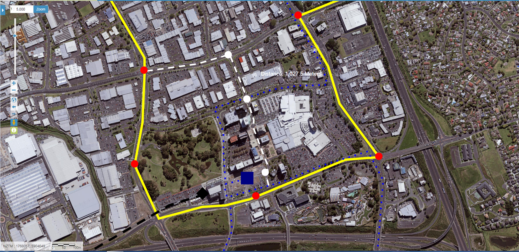
But the Southern Airport Line is just not about transit to the Airport (for either passengers or workers at the airport), the proposed Line also has 16 stations including two Terminus stations and two major interchanges. The Southern Airport Line also crosses through some diverse land uses including the Airport, blank land zoned Light Industry, various residential areas and two Metropolitan Centres including Auckland’s largest Metropolitan Centre – Manukau City Centre.

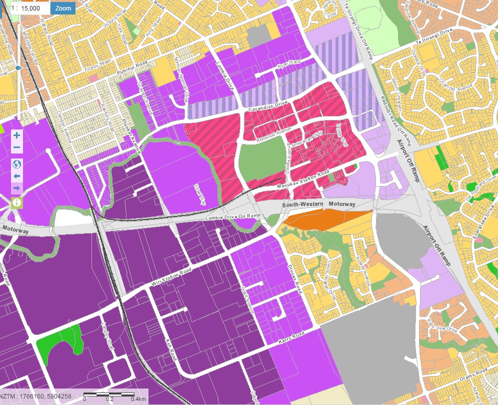
Metro Zone in dashed pink

Source: Auckland Plan Implementation Update 2015

However, it is not a case of draw your 200, 400 and 800 metre radii from those transit stations and slap in some high density developments – far from it. Each station along the Southern Airport Line is unique and no two stations would be the same nor serve the same urban geographic characteristics of another station on the line. When it comes to handling the 16 Transit Orientated Developments for each of the Southern Airport Line’s 16 stations, the Design-Led system is put to the test.

Source: Panuku Development Auckland

Ludo Campbell Reid (Auckland Council Design Champion) was talking about Design Led systems yesterday also at the Planning Committee – which have major influence on TOD type developments. You can see Ludo’s presentation here:
Ludo’s presentation and my own presentation interlinks very well. The Southern Airport Line is just more than a Rapid Transit Network line between two places (Botany and the Airport) it is also a place where 16 world-class design led developments can be executed giving 16 world-class (and different) places to either work, live, play, educate or even all (Manukau City Centre).The catch becomes sure we can build this Rapid Transit Network connection with its 16 stations including two terminus stations (Airport and Botany) and two major interchanges (Puhinui and Manukau Central) – that is the easy bit. The challenge is how to produce 16 design led type urban developments within 800 metres of each station – that is how do we get maximum bang for buck for the Southern Airport Line and Auckland as a whole.
Auckland is undergoing explosive growth in population, commercial and industrial. Congestion is also a shocker so keeping residential and jobs close to a transit station would seem prudent. To do this though quality amenities need to be in place for each station to support best utilisation of land within 800 metres of each of the 16 stations. Enter Ludo’s Design Led mantra in not only delivering just transit stations but individual while interconnected communities along a busy transit corridor!
The question I have though: Do we have the resources to allow 16 world-class Design led stations and surrounding communities.
More to the point has anyone done a Transit Orientated Development for a station in a Light Industry area before?
—ends—

