
Utrecht embarks on regeneration like Transform Manukau. Could the Dutch have Ideas for Us?
As Transform Manukau continues along (although with some poor initial outcomes – Manukau Bus Station and Putney Way (see: Manukau Bus Station First Pictures – Underwhelmed, Putney Way Already a Race Track Not a Pedestrian Friendly Street AT Say It Will Be) it is time to take a quick stock take and review plans to adapt to an ever-changing environment. Since Manukau was listed as a potential Transform urban regeneration project by Auckland Council and Panuku Development Auckland followed on by the High Level Project Plan and Framework Plans the environment has changed quite a bit for Manukau.
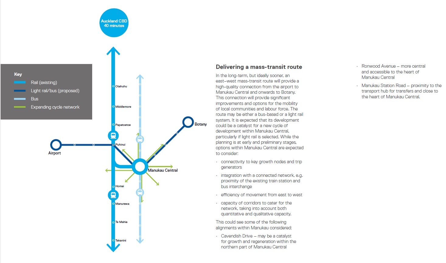
The biggest changes have been the change of Government and the change of CEO at Auckland Transport. While any changes from AT will be a while (there seems to be a leadership vacuum in AT right now) changes influenced by Central Government are more immediate. The announcement of projects like Regional Rapid Rail and the Southern Airport Line (Botany to Airport Rapid Transit via Manukau and Puhinui) already change the dynamics for Manukau in that two rapid transit projects that were listed as super long-term in the Framework documents became actual very fast (see: Regional Rapid Rail and The Southern Airport Line a (virtual) GO!)
Source: Panuku Development Auckland
The Auckland Plan changes in that Manukau will become one of three Nodes outside of the City Centre as Council tries and drives a multi-nodal approach after the original mono-centric approach of the last six years ultimately failed. This means increased attention for Southern Auckland’s core especially as the South continues to race in population and employment growth to which I believe for the first time Southern Auckland has exceeded the Isthmus in terms of nominal population (will need to see Census 2018 for confirmation).

Source: http://transportblog.co.nz/2016/04/21/central-auckland-population-growth-1891-2013/


Finally the Minister of Transport, Housing and Urban Development Phil Twyford has made it extremely clear that things are progressing too slow in Auckland and that via his Urban Development Authority (UDA) and NZTA (of all agencies but – this is a good thing given the strong directions set in the draft Government Policy Statement (see: Government Releases Draft Government Policy Statement for Consultation (Due May 2))) developments are to increase both in Auckland and its satellites in the northern Waikato. Meaning we will see greater emphasis on inter-regional planning and connections.

Source: Panuku Development Auckland

Source: Panuku Development Auckland
As we can see from above Panuku have mapped out changes to Manukau but they were at long-term time frames rather than now short-term time frames currently being pushed. The time frame changes (mainly triggered by Government) is thus the reason why it is a good time for a stock take and a refresh on delivering outcomes for Transform Manukau.
For starters what we have been delivered with Manukau Bus Station (incapable of taking through route busses like the 33 Great South Road service and the soon Airport to Botany Bus Rapid Transit busses (if we go bus rather than Light Rail Transit (then again the station is not even set take LRT)) while Putney Way is anything but a shared space) can not be continued with any other Transform Manukau project. All future projects must be fit for purpose now and into the future given Transit Orientated Developments are to be the key fundamental when an area has Rapid Transit Networks running through them (Manukau has two).


So how do we proceed?
Time to go to The Netherlands and look at how Utrecht Overvecht handled turning a 1960’s street grid into a 21st Century human-centric Centre.
From BICYCLE DUTCH:
Making a 1960s street grid fit for the 21st century
Today’s Sustainable Safety policies demand a type of street design that is completely different from what was actually built in the 1960s, also in the Netherlands. So can you re-design streets that were built in a time when the car got all the space it needed, and more? Can you change those streets to meet the objectives of today’s safety and traffic management policies? And can it be done within reasonable budgets? Well, yes, Utrecht proves that it is possible!

As part of a much larger plan to redevelop a 1960s housing estate in Utrecht, the street grid in this neighbourhood called ‘Overvecht’ will be completely updated to the 21stcentury Dutch standards. The new street grid will make the area safer, more attractive and more liveable. The city achieves this by concentrating the main motor traffic flow better and in fewer designated streets and by changing many other streets into 30km/h (19mph) zones to give more and a safer space to people walking and cycling. The plans are currently executed and a number of former main streets was already narrowed to exactly half their original 1960s width.
In the publication “Looking at Overvecht” the Utrecht alderman explains:
“With its spacious layout with predominantly high-rise buildings and generous amounts of green space, Overvecht is a characteristic product of 1960s urban planning. The estate has approximately 40,000 residents, many of them in the social-housing sector. In response to Overvecht’s problems since the beginning of the 21stcentury, the city council and housing corporations have been working together with residents, contractors and professional partners to improve the neighbourhood both physically and socially.”
In this post I zoom in on the north-west quadrant of the neighbourhood that houses about 10,000 people.

In the original 1960s street grid for this area, motor traffic was able to use all streets to get from one end to the other. Some streets were even wider than others and served as through street. Most streets were purely residential, but all streets had the same speed limit of 50km/h (31mph). To channel the traffic flow better, the city designated a so-called ‘neighbourhood ring’. This is the street that is designed to give quick access from the city’s arterial roads to the purely residential streets. The latter type of streets have all become 30km/h (19mph) streets. This means that no 30km/h street has a direct access to an arterial road, but that traffic is forced to use the neighbourhood ring to get to the main arteries via only very few access points.
……..
Source: https://bicycledutch.wordpress.com/2013/08/08/making-a-1960s-street-grid-fit-for-the-21st-century/
Utrecht Overvecht like Manukau is situation not far from a main centre or this case two centres. For Manukau it is Auckland City Centre and Hamilton, with Utrecht Overvecht both Rotterdam and Amsterdam are in close proximity and easily reached by rail. Manukau like Utrecht Overvecht are City Centres but minor ones when compared to the primary Centres nearby however, that does not diminish Manukau nor Utrecht Overvecht in anyway in their roles as City Centres. Utrecht Overvecht like Manukau was built as a car-centric Centre and both are equally blessed with grid street patterns unlike Albany and Botany Metropolitan Centres.

Utrecht Overvecht like Manukau is also blessed with an over abundance of surface parking lots. All the shortcomings of car-centric designs and surface parking lots aside it is those same shortcomings that present the most opportunities to both Centres.
This is what Utrecht Overvecht is undertaking with their urban regeneration project:


Utrecht Overvecht’s urban regeneration plans could be easily translated to Transform Manukau sure but it also showed how Manukau can do things better. The Putney Way upgrade in front of the Manukau Bus Station was an opportunity missed to blockade the street and turn it into a pedestrian mall just as Utrecht Overvecht has done in several places. There are no drive ways on Putney Way (the one that does link to the surface parking lot can be closed as the lot can be accessed from Davis Avenue) so like Fort Street in the City Centre service vehicle access can be limited to 6am – 11am. Apart from that there is no legitimate reason for Putney Way to be open to any other traffic. Kiss and Ride and Taxis stands should be on Davis Avenue between MIT (where the Rail Station is) and the bus station as that is the central point of all transit modes (including inter city coaches that will use the bus station). So lets get Putney Way closed and Manukau enjoy its first true people space without having to worry about cars and taxis treating the street as a racetrack – as they will and actually already are.
Back out to wider level I am going to look at the high level plans I drew up for Manukau and evaluate them against Utrecht Overvecht’s designs:


I still have the base drawings of the sketched layout on Manukau. Updating them to reflect key lessons from Utrecht Overvecht such as individual road and street treatments would be a critical evaluation exercise especially as Transit Orientated Developments become the forefront in the next phase of Urban Geography.
The key lesson Utrecht Overvecht offers Manukau is do not be afraid to:
- Blockade streets
- Blockade streets
- And the streets you still have open reduce to 30km/h at absolute max
From there you encourage medium and high density developments especially when a major transport hub is in the area and streets becoming people spaces not spaces two park or race through two tonnes of metal.
In Cities Skylines I am trying the Utrecht Overvecht scheme in my latest city – San Layton City. The main Core (the City Centre has not fully developed yet) is built around a bus station with the heavy rail and light rail stations in close proximity (remind you of a certain Super Metropolitan Centre 😉 ). If I had built this core conventionally then there would have been roads connecting back to the main thoroughfares all over the show causing the area to be clogged with cars. Instead I used a pedestrian mall street that bans cars while linking the bus station up by a standard road on oneside and a mini busway on the other. What you get is a Transit Orientated Development for people that is readily accessible by transit, walking or cycling:
If Utrecht Overvecht can create people-centric spaces and I can do it via an urban simulator then there is no reason why we can not do the same with Transform Manukau.
Time to give the Plans a refresh!

