
Green Infrastructure not only boosts mental health and productivity, but also acts as natural defences for urban areas, especially in heatwaves and storms!
News of Wellington receiving 77mm of rain in ONE hour last night (anything over 7mm/hr is considered heavy rain) resulting in extensive flash flooding has unfortunately served as a reminder of the risks our urban areas face from these events. Our grey infrastructure (pipes) were never designed to cope with that level of storm intensity to the point they can make the flooding even worse because of their shortfall. Meanwhile urban sprawl an intensification continues which will only intensify flash flooding events if the stormwater planning is not done properly. On the same side of the urban coin is the increasing need for green spaces will only intensify as well.
However, Green Utility or Green Infrastructure serves as a dual role. It serves both as a recreation spot for residents and visitors, as well as stormwater infrastructure every time the weather decides it is Noah’s Ark worth of rain day. Two for the price of one. And as we know with the Auckland floods in 2023, more modern urban development handled the floods much better than older parts of Auckland thanks to that Green Infrastructure.
With that in mind, just slapping in some parks, calling it Green Infrastructure, then calling it day hoping it works would be pretty up there on the hope-ium (and cope-ium). Like any form of infrastructure, planning needs to be done prior to any investment, followed up by maintenance suited to the green infrastructure you are wanting to build. Even large green infrastructure types need the odd bit of maintenance there and there to continue to work effectively.
So, lets dig into some planning and take a look at some Green Infrastructure using the 3:30:300 rule
Project: The Green Utility Network
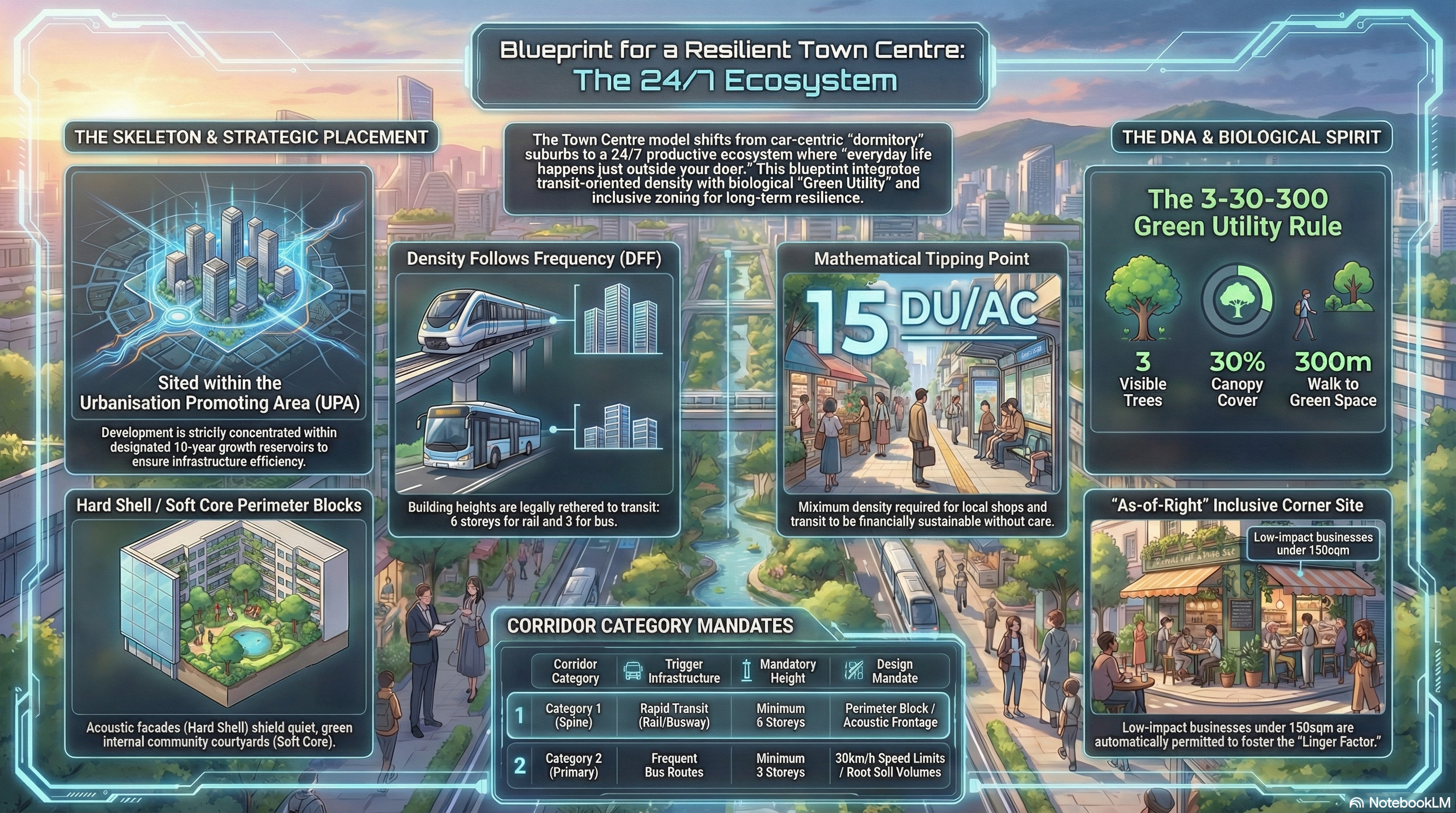
Based on the Aotearoa Planning Bill 2025 and the Resilient Habitat Equation, here is a comprehensive design for an Urban Public Parks Network.
This design moves away from the “ornamental” view of parks (nice-to-have decorations) to a “Green Utility” model, where nature is treated as essential biological infrastructure required for urban operation.
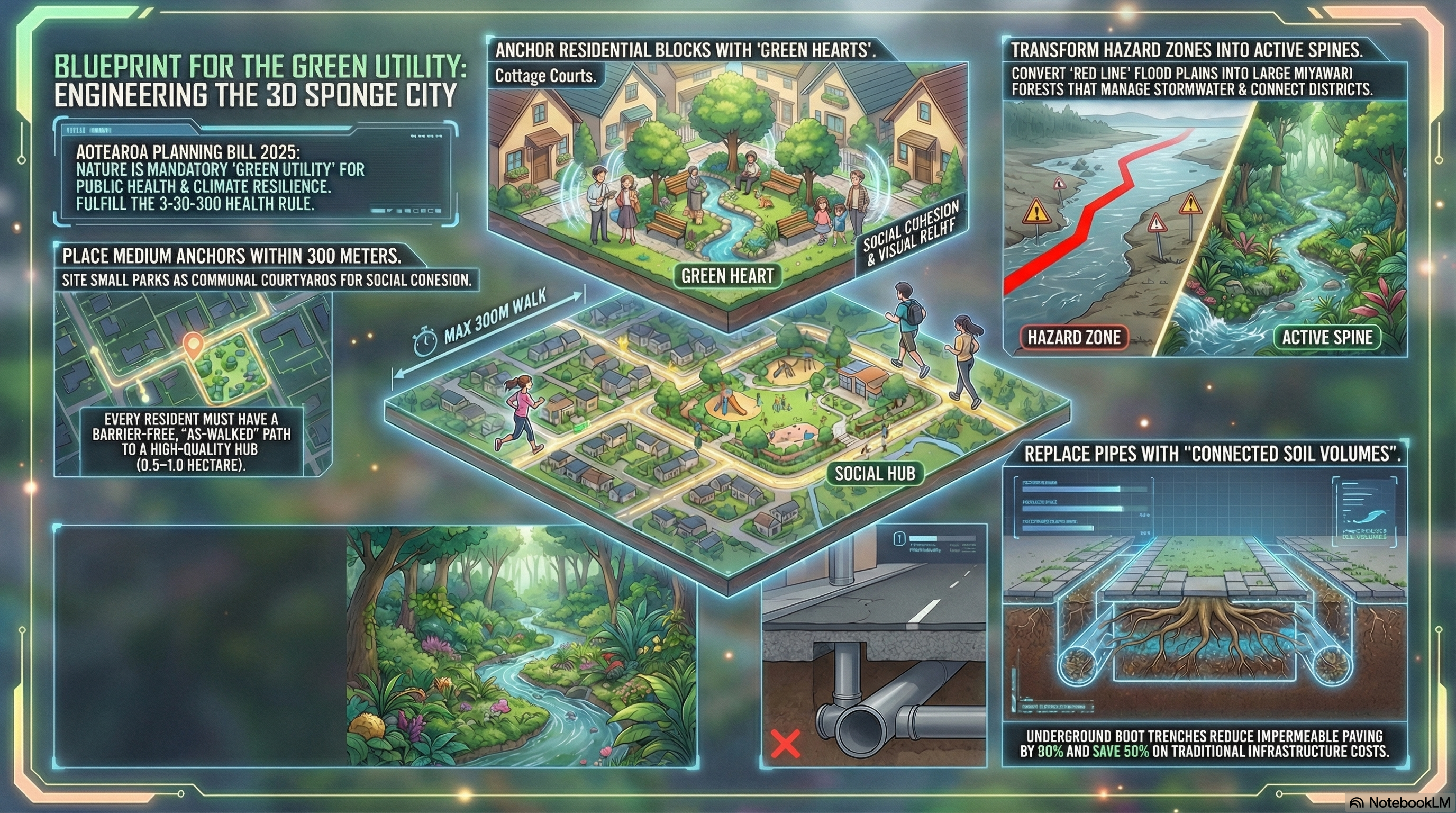
Mandate: Public Welfare Supreme (Greenery is a nutritional requirement for urban health). Core Metric: The 3-30-300 Rule (3 Trees visible, 30% Canopy cover, 300m to a park). Location Status: Integrated throughout the Urbanisation Promoting Area (UPA).
Layer 1: The Macro-Structure (The “Red Line” Spines)
We utilize the Red Line Policy (Hazard Avoidance) to define the major arteries of the park network. Land that is unsafe for housing becomes the backbone of the green network.
- The Strategy: Land identified in the “Top-Left Risk Quadrant” (High Likelihood + Catastrophic Consequence) based on a 100-year climate horizon (to 2126) is designated as “No Build” zones.
- The Design:
- Blue-Green Corridors: Flood plains and coastal inundation zones are converted into linear parks and wetlands.
- Function: These act as “Sponge City” infrastructure, managing stormwater naturally and reducing the need for expensive concrete pipes (CAPEX savings of up to 50%).
- Connectivity: These corridors serve as the primary “Active Travel” highways (cycleways/walking paths) connecting different districts without crossing heavy traffic.
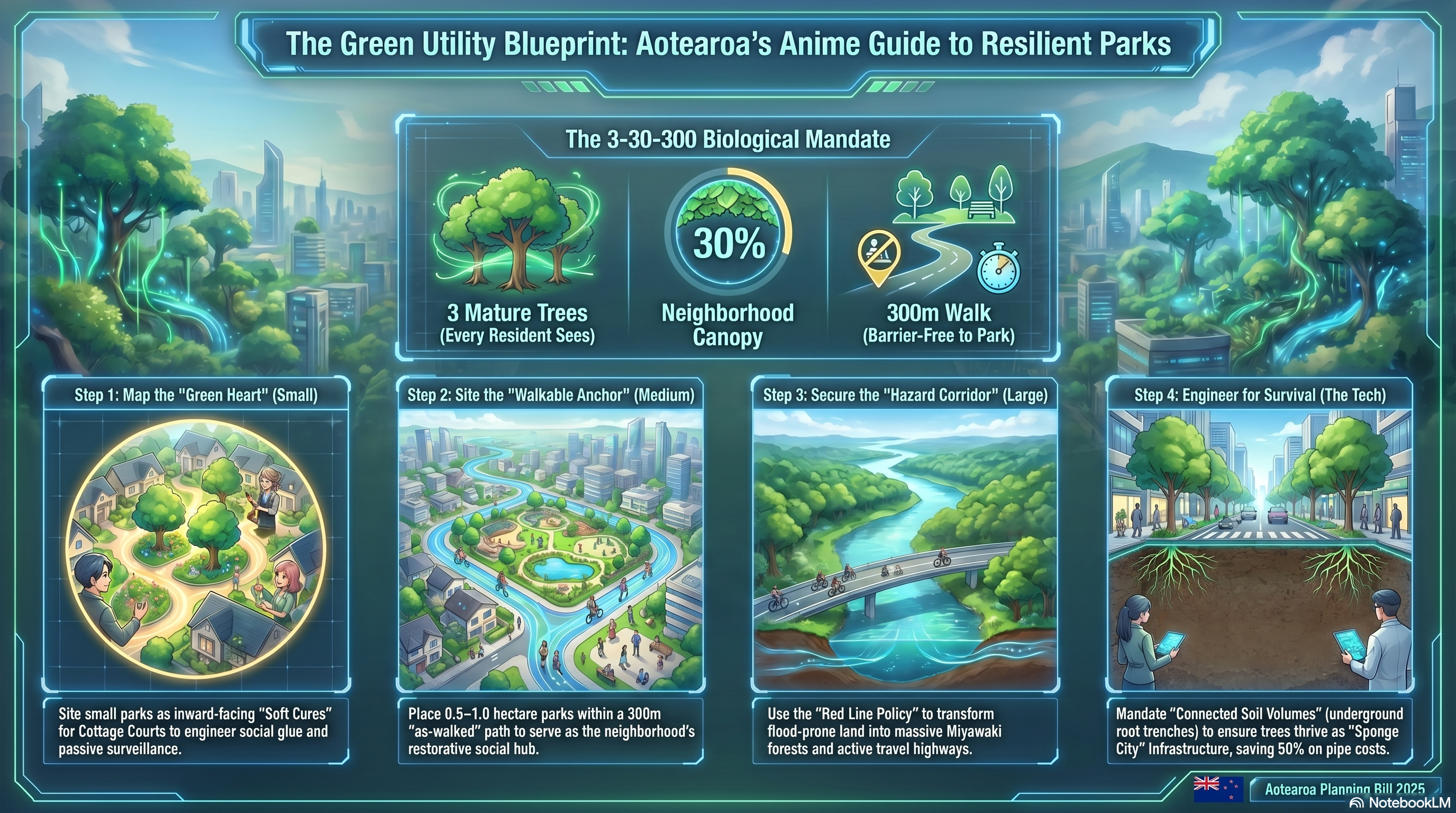
Layer 2: The Neighbourhood Anchors (The 300m Grid)
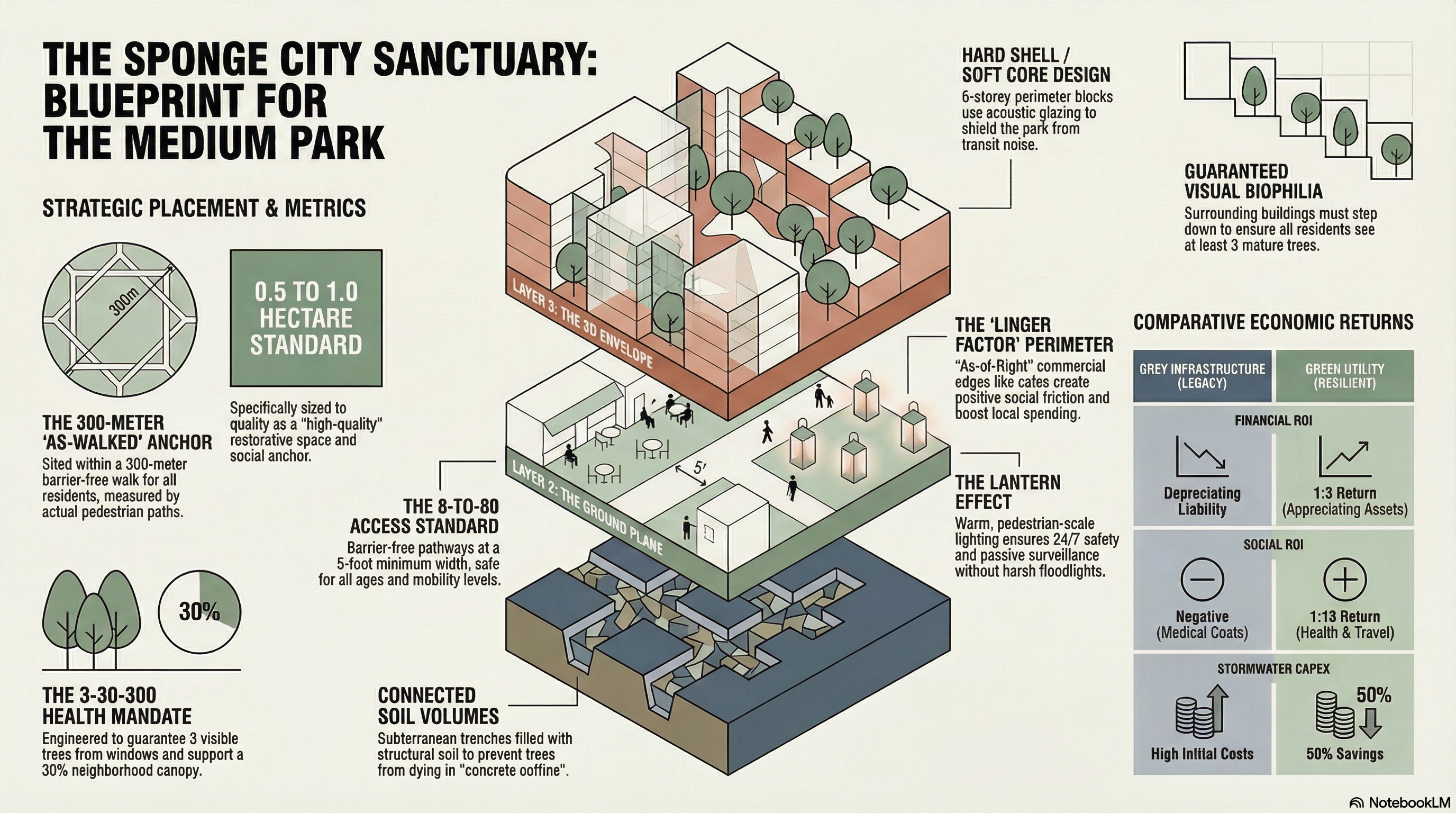
To satisfy the “300 Rule” (every resident must be within a 300-meter barrier-free walk of a green space), we overlay a grid of neighbourhood parks.
- The Standard:
- Proximity: 300m maximum walking distance (measured by actual path, not “as the crow flies”)
- Minimum Size: Each anchor park must be 0.5–1.0 hectares to qualify as “high quality” restorative space.
- The Location Strategy:
- In Residential Zones: Parks are sited to function as “Third Places”—communal living rooms where social glue is formed 9.
- In Industrial Zones: Parks are mandatory even in Exclusively Industrial zones to ensure workers have access to mental restoration and breaks.
- Acquisition Tool: Councils use “Scheduling Areas” to designate and acquire this land before rezoning occurs, freezing land values to prevent speculation and ensuring the network is affordable.
Layer 3: The Circulatory System (The 30% Canopy)
The streets themselves are redesigned as linear parks to achieve the “30 Rule” (30% canopy cover across the neighbourhood). This mitigates the Urban Heat Island effect and filters air pollution.
- The Engineering Mandate: Connected Soil Volumes
- The Problem: In dense Category 1 & 2 Transit Corridors, trees planted in isolated “concrete coffins” die young and fail to provide canopy.
- The Solution: We mandate “Connected Soil Volumes”—continuous underground trenches of structural soil beneath the pavement.
- The Result: Roots can spread and share nutrients, allowing trees to reach full maturity and create a “cathedral” canopy over the street, even in high-density areas.
- Universal Access: All green streets feature 5-foot minimum sidewalks and pedestrian-scale lighting, ensuring the network is accessible to an “8-year-old on a bike and an 80-year-old in a wheelchair”.
Layer 4: The Micro-Green (The “3 Trees” & Soft Cores)
To satisfy the “3 Rule” (3 trees visible from every home/workplace), we integrate greenery into the private realm using specific architectural typologies.
- The “Soft Core” Sanctuary:
- Typology: In Category 1 (Spine) corridors (6+ storeys), we use the Perimeter Block model.
- Design: The building’s “Hard Shell” (acoustic façade) faces the street, protecting a quiet, green “Soft Core” (courtyard) inside.
- Function: This internal courtyard serves as a visual anchor for residents (satisfying the “3 Trees” rule) and acts as a localized stormwater sponge.
- Cottage Court “Green Hearts”:
- Typology: In Category II Residential zones, small homes are clustered around a shared “Green Heart” (common lawn) rather than a driveway.
- Function: This forces “positive social friction” and ensures immediate visual access to nature for every unit.
Layer 5: Implementation & Governance
- Role of Council: The Council shifts from policing private aesthetics to “Design-Led Placemaking” of this public network. They use Promotion Area Zones to apply bespoke overlays for high-quality paving, lighting, and planting in these green spaces.
- The ROI Calculation: This network is justified not as a luxury, but through Triple ROI:
- Financial: 1:3 ROI on tree maintenance (appreciating assets) vs. depreciating grey infrastructure.
- Social: 1:18 ROI in health savings from increased active travel and reduced stress.
- Infrastructure: 50% savings on stormwater CAPEX by using the parks as “sponges”.
Summary of the Network Design
- Component, 3-30-300 Element, Function, Engineering Requirement
- Red Line Spines, Network Backbone, Hazard avoidance / Active Travel,100-year risk modelling
- Anchor Parks, 300m Distance, Community Hub / Recreation, Min. 0.5 Hectares
- Green Streets, 30% Canopy, Cooling / Connection, Connected Soil Volumes
- Soft Cores, 3 Trees Visible, Mental Health / Visual Relief, Perimeter Block Typology
Example of building a medium-size park
With the medium park likely to be the most common park in the public realm, below is set guide on planning and building those effective medium parks.
Based on the Aotearoa Planning Bill 2025 framework, “high-quality green space” under the 300-meter rule is not defined by vague aesthetic guidelines but by specific, non-negotiable engineering and public health metrics. It is treated as “Green Utility”—essential infrastructure required for human survival, similar to sewage or electricity.
Here are the specific definitions that qualify a space under this rule:
1. Minimum Size Requirements
To qualify as “high quality” and provide necessary restorative benefits, the green space must meet a specific physical scale. The framework mandates a minimum size of 0.5 to 1.0 hectares 3-6. This ensures the space is large enough to function as a “Third Place” for community gathering rather than just a small ornamental verge.
2. The “As-Walked” Measurement
Proximity is measured by the reality of the street grid, not theoretical closeness.
- Actual Path: The 300-meter distance is measured by the “actual pedestrian path” (the specific route a person must walk), not “as the crow flies” (a straight line on a map).
- Barrier-Free: The path must be a “barrier-free walk,” ensuring accessibility for all residents, including the elderly and disabled.
3. Functional Purpose
The space is engineered to deliver specific biological and social outcomes:
- Mental Restoration: Grounded in Attention Restoration Theory (ART), the space must provide “soft fascination” (e.g., trees, nature) to allow the brain to recover from urban cognitive fatigue.
- Social Anchor: It functions as a “Third Place”—a communal living room just outside the front door—designed to facilitate “positive social friction” and combat isolation.
- Universal Application: This requirement is mandatory across all zones, including Exclusively Industrial areas, ensuring that workers also have access to mental restoration and breaks.
In summary, a high-quality green space is a 0.5–1.0-hectare park located within a 300-meter barrier-free walk of every resident and worker, treated as a mandatory utility for mental health and social resilience.

