Category: Urban Planning and Design

Looking at Urban Planning and Design

Public Meetings on The Clunker

Preconceived Motions Do NOT Help Anyone


At times I have to play the devils advocate and go into bat for those I often would not. Last night at the Weymouth Public Meeting on the Southern Rural Urban Boundary and the Karaka-Weymouth Bridge, the poor planners pretty much got ambushed by some (not all – as I am being fair) of the Weymouth residents last causing the presentation to be cut short considerably. After talking to some of the other residents, then going one-to-one in front of the Unitary Plan maps with more interested residents  I can concluded (to my own opinion) some points out of that meeting:

  1. The majority of residents  have not read The Unitary Plan (I know it’s an 1854 page clunker but do what I do and read specifics to your area of concern (so anything south of Otahuhu)) at all including the Rural Urban Boundary Addendum. Meaning a minority have read at least some of The Clunker and (to be frank) showed in the line of questions they were asking. 
  2. Are not actually asking key players questions they might have on issues. The Karaka Bridge I would be hammering the AT Board for an answer until a resolution came out of there (sorry Christine I know that means more pressure but they need certainty in Weymouth)
  3. Someone in AT has shot their mouth off on the Karaka Bridge before the Board has made any firm decision on the bridge (I need to get a hold of that letter that particular resident had from AT)
  4. Majority of residents holding of preconceived motions – this comes from point one and they most likely not reading The Clunker. I really wanted to those residents holding a preconceived motions on the Karaka Bridge that at this point and time no FINAL decision has come out of AT (if it has then the Board is hiding something). Like the Eastern Highway the designation (if there is one for Karaka in the first place) has to be in the maps for all to see, this is in case NZTA decide to go run with the particular project and decide to build it. The only way to have the designation removed from a map for good is to get NZTA to remove the designation formally!
  5. If one does not know something, we will just go insult the planner anyway – not acceptable nor mature from residents who should know better. I don’t personally have time to rock up to public meetings to go learn something, talk to people, and enter dialogue if all some residents are able to do is fling insults. For your information South Auckland is anything south of Portage Road Otahuhu to the Franklin Local Board area in which it then becomes Counties Auckland. Overall the area is known as Southern Auckland! 


I wish I had my maps with me last night along with Councillor and AT Board Member Chris Fletcher‘s comment on the Karaka Bridge – as well as the RUB (as I had it in A4 colour) to help the planners. But I did not know the meeting would turn out the way it did, and I am hating to think how this is going to turn out in two weeks when the Mayor and Deputy Mayor trundle along.


This is Chris’s comment on the Karaka Bridge made recently:

Christine Fletcher There is strong opposition from the Karaka Residents I know to the proposed Weymouth Bridge. I am aware of a number preparing submissions in objection. It is a ridiculous proposal. It has no funding and does not appear in any planning document. Given that we don’t have sufficient funding for our existing and approved transport projects it is wrong to distress so many people on a proposal that will never go anywhere. Further evidence of the flawed thinking around the ill-considered Unitary Plan. You can imagine Penny Hulse and Roger Blakely playing with a big felt tip pen oblivious to the respective communities. I don’t think that I can attend that meeting but I will put you in touch with the independent planner consultant who is helping residents to draft their submissions.


I stress that Chris’s comment be read and taken into account. I also stress then grill the Deputy Mayor in two weeks on the bridge and how the heck it got there – but please residents; READ THE SOUTHERN RUB DOCUMENT FIRST PLEASE!


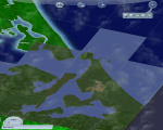
These are the maps on the Southern RUB last night that the residents would not have been able to see (yes you can print them):


I also stress the following point made in the maps:

  • Waste water treatment plant and transport link likely to be required


Emphasis on likely but not a “must” (although that treatment plant is going to end up as a “must”)


I am also going to reiterate what I said yesterday:

I have commented on this with my “THE RURAL URBAN BOUNDARY – SOUTH END“” post last week – briefly recapping:

Personally I am in favour of the Draft Southern RUB Options – Corridor Focus (Page 4 of the embed) which contains primary urban development to Drury and Karaka (Core’s K and D), along the State Highway 22 and North Island Main Trunk Line rail corridor, the North East Pukekohe flank, and the Pukekohe South East flank. This option keeps the main development either near existing development or along a transit corridor making infrastructure provisions (Drury and Paerata Rail Stations) and access more easier than the other options such as those that include Karaka North and West. Per The Unitary Plan there is an option to retain a green belt between Pukekohe and Paerata which would provide a wildlife corridor as well as park space. While development is kept away from the highly valuable Pahurehure Inlet which according to the maps contains colonies of wading sea birds. In any case that area slated as Karaka North and West if need be can be converted either into lifestyle blocks with strict covenants or over time into a new regional park and green lung for the ever-growing Auckland (which is what I would prefer Council would do (like an Ambury Farm or Puhinui Reserve set up)).

I have also noted as potential transport link from Whangapouri to Weymouth via a new bridge over the inlet as well as talk of a new waste water treatment plant. With me preferring the corridor option thus Karaka West and North not being developed – but actually wanting to be flipped over to lifestyle blocks or even better a regional reserve I can not see the need for a transit link through that area connecting to Weymouth. That link would create a rat-run from State Highway 20 at the Cavendish Drive Interchange, down Roscommon and Weymouth Roads (Route 17), over the new bridge, down the new transit link and through to State Highway 22 just north of Paerata rather than containing it to State Highways 1 and 22. That kind of rat running would lower the amenity of the new Greenfield developments and do nothing to solve congestion issues. As for the waste water treatment plant, well with Karaka North and West no longer under development you can away plop the new plant there out of the urban road but near the potential outfall site.


Submission wise I am going to follow through and “recommend” toAuckland Council that the Corridor Option for the RUB being the preferred southern Greenfield development options, providing there is:

  • A green belt maintained between Pukekohe and Paerata

  • New waste water treatment plant is built

  • That transit link over the Inlet is not built

  • What was labelled Karaka North and West either be allowed to be converted to Lifestyle blocks or even better a regional reserve seeming wading birds live in those areas

  • And that Auckland Transport will build the Drury and Paerata Mass Transit Interchanges (rail and bus station, and park and ride)


So what I am getting at in this post is the following:

  • Do your reading first and dump any preconceived ideas you have at the door
  • A submission simply opposing something is useless, you need to play the Council and AT at their own game and get an actual alternative across that is viable and a win-win for all. I have as seen in the above statement and is a card I am using in working with Council and the Unitary Plan that is a win-win for most (just not the land banker in Karaka West)


There is another meeting in two weeks time with the Mayor and Deputy Mayor being invited to be present at Weymouth School Hall. I will be present again and this with my maps and hopefully a clarification from Auckland Transport in that cursed bridge. In the meantime I am off to Milford tonight to go listen in on the intensification plans IN THAT AREA which is causing a certain amount of heart ache for residents over there.


One final thing: I know what the residents in Weymouth are staring down as I am staring down the exact same thing with the Mill Road corridor and the consequences it will cause (rat running being the main one) on the transport side. With intensification I also know what the Weymouth residents can be staring down as my house is up for re-zoning from Residential-1 to “Mixed Zoning”  (see my:  ) and the fact I am only 100 metres away from the Papakura Metropolitan Zone which allows buildings to go up to 18 stories high (economic conditions permitting). RUB wise I can also share the Weymouth residents concerns and the impacts that can actually cause. For me it affects the trains and State Highway One transport wise as more people need to be moved from the south. To the north of me I could be staring down 15,000 new houses if the RUB at Addison gets moved eastwards despite it being a floodplain. So Weymouth and Papakura are in the same boat here with The Clunker in all regards. I can understand anger and frustration but I do not tolerate preconceived motions nor insulting planners who are the messengers. You have a beef; take it with the Councillors and the Mayor…


The Clunker and an Unnecessary Road

The Weymouth Link – Is It Needed?


In short no!


I have commented on this with my “THE RURAL URBAN BOUNDARY – SOUTH END“” post last week – briefly recapping:

Personally I am in favour of the Draft Southern RUB Options – Corridor Focus (Page 4 of the embed) which contains primary urban development to Drury and Karaka (Core’s K and D), along the State Highway 22 and North Island Main Trunk Line rail corridor, the North East Pukekohe flank, and the Pukekohe South East flank. This option keeps the main development either near existing development or along a transit corridor making infrastructure provisions (Drury and Paerata Rail Stations) and access more easier than the other options such as those that include Karaka North and West. Per The Unitary Plan there is an option to retain a green belt between Pukekohe and Paerata which would provide a wildlife corridor as well as park space. While development is kept away from the highly valuable Pahurehure Inlet which according to the maps contains colonies of wading sea birds. In any case that area slated as Karaka North and West if need be can be converted either into lifestyle blocks with strict covenants or over time into a new regional park and green lung for the ever-growing Auckland (which is what I would prefer Council would do (like an Ambury Farm or Puhinui Reserve set up)).

I have also noted as potential transport link from Whangapouri to Weymouth via a new bridge over the inlet as well as talk of a new waste water treatment plant. With me preferring the corridor option thus Karaka West and North not being developed – but actually wanting to be flipped over to lifestyle blocks or even better a regional reserve I can not see the need for a transit link through that area connecting to Weymouth. That link would create a rat-run from State Highway 20 at the Cavendish Drive Interchange, down Roscommon and Weymouth Roads (Route 17), over the new bridge, down the new transit link and through to State Highway 22 just north of Paerata rather than containing it to State Highways 1 and 22. That kind of rat running would lower the amenity of the new Greenfield developments and do nothing to solve congestion issues. As for the waste water treatment plant, well with Karaka North and West no longer under development you can away plop the new plant there out of the urban road but near the potential outfall site.


Submission wise I am going to follow through and “recommend” to Auckland Council that the Corridor Option for the RUB being the preferred southern Greenfield development options, providing there is:

  • A green belt maintained between Pukekohe and Paerata

  • New waste water treatment plant is built

  • That transit link over the Inlet is not built

  • What was labelled Karaka North and West either be allowed to be converted to Lifestyle blocks or even better a regional reserve seeming wading birds live in those areas

  • And that Auckland Transport will build the Drury and Paerata Mass Transit Interchanges (rail and bus station, and park and ride)


But in this post I am going to open the floor to Manurewa Local Board Chair Angela Dalton with her Manurewa Action Team through her Scrid document:


Attribution to Angela Dalton – Chair of the Manurewa Local Board


And yes I am trundling along to the Weymouth Community Meeting tonight at 6:30pm discussing the Weymouth


The Unitary Plan is a Clunker

1854 Pages?


I have mentioned in the past that the Draft Unitary Plan was around 500 pages and it was larger than our largest Bible at home. Well it seems I got that number wrong as the Draft Unitary Plan actually stands at 1854 pages and takes Councillor George Wood two car trips to get the sole Council copy of this clunker to a public meeting.


1854 pages? What the flying heck Auckland Council, that is not a plan but just an actual dead weight to anyone and everything in the city. Maps aside, the idea was to get this clunker down to 100 A4 pages so that it was easy for everyone to read to access. Not just be a play thing for city planners and Environment Court Lawyers that costs us more money.


Bernard Orsman for the NZ Herald had this to say on the Clunker this morning:

Struggle to access copies of city plan

By Bernard Orsman @BernardOrsman

5:30 AM Thursday Mar 28, 2013


Navigating complex document online and finding a printed version proving difficult.

Many Aucklanders are struggling to find out if their neighbourhood is earmarked for high-rise apartments, heritage protection or the status quo in the new planning rulebook for the city.

The 1854-page draft unitary plan includes provisions for high-rise and multi-rise apartments and the nuts and bolts of what people can do with their properties.

But people are complaining about difficulty using the online version of the plan and trying to access 29 hard copies at local board offices, Auckland Town Hall and some libraries – about one copy for every 50,000 people.

At a public meeting in Mt Eden on Tuesday night, there was no material for locals to take away on the changes proposed for the suburb, only a single copy of maps to browse.

Birkenhead resident M. Carol Scott said in a letter to the Herald that she found the online document a “tortuously clunky process” and all she got from her local library was a brochure inviting her to “shape the world’s most liveable city”.

“Clearly, creating a Super City planning rulebook is a huge task, but how democratic is this process?” she said.

The Auckland Transport Blog said unlike the Auckland Plan – the 30-year blueprint for the city – the new rulebook was not a nicely worded document, but a complex, hard-to-use resource management document.


You can read the rest over at the Herald


Personally I am not finding the e-document that easy to use and I regard myself as tech savvy. Even with Bookmarks applied in Chrome and until I saved the PDFs to my hard drive, it would take several attempts floundering around different parts of the Unitary Plan site to get to the two areas I am focusing on at the moment: The Rural Urban Boundary addendum, and the Zoning Rules in an effort to get them simplified even further.  What is not helping is that you can read the PDF like the RUB material in question, but then you have five different maps showing “options” for the RUB rather than consolidating it as one PDF file. Thankfully I consolidated those maps into a single PDF and stuck it in Scribd last night – but heck that is annoying to do what the council should have done in the first place.


As a result in the Unitary Plan being a clunker and at over 1854 pages making it impossible to print – even if I did get the entire thing as a single PDF, getting a meaningful submission in is going to be an interesting task ahead.


However, I am off to the Papakura Local Board Unitary Plan session next month to see if I can make heads or tails of The Clunker before getting my submission in.


And now that I have that little rant off my chest this morning, my next Unitary Plan post will be on residential zoning. It’s Sim City meets Auckland Unitary Plan – here at BR:AKL


BEN ROSS : AUCKLAND

Shining The Light – To a Better Papakura (OUR home)
AND
To a Better Auckland – (OUR City)

Auckland 2013: YOUR CITY – YOUR CALL


The Rural Urban Boundary – South End

The Unitary Plan


And


The Southern Rural Urban Boundary


I have been meaning to get this up this morning but the perennial issue called Auckland Transport has being cropping up again.


So the Unitary Plan is out for informal feedback from Auckland and we have central government sticking its nose in our affairs when it should learn to butt out. Commentary on the Unitary thus far has been rather weak on the actual issues at hand: the rules, the zones, the RUB, the infrastructure deficit which is eye watering, and how to deliver all this from (at this rate) September. Then again once our Deputy Mayor gets MP Nick Smith out of the city and tell him to butt out as he is being counter-productive attention might be drawn back to the rule book that affects the lives and businesses of Aucklanders.


As mentioned before I went away on holiday, commentary on the Unitary Plan will start as BR:AKL looks at the issues at hand. At the same time a series on an alternative to the Unitary Plan will run in parallel to Unitary Plan commentary. Today I am going to look at the Southern Rural Urban boundary where upwards of some 57,400 new Greenfield dwellings could end up depending on the option. This kind of Greenfield development stems from the Auckland Plan calling for 60% of urban development to happen in Brownfield land with the other 40% in new Greenfield land. The Southern Rural Urban Boundary (RUB) is one such spot (the others being in the North and North West of Auckland) where some of that 40% is meant to go.


For those wondering what a Rural Urban Boundary is, please check THIS LINK from the Unitary Plan on its description.


As for the Southern RUB there are three development options Auckland can take with this Greenfield Land (which is 15 minutes away from where I live by car). You can see all three options layered over a GIS Map and a GIS Map with an Issues and Constraints Overlay as well as each of the three options below in the embed below:

The two GIS maps (pages one and two) have dwelling capacity limits for each of the Greenfield zones depending on which option is taken.


Personally I am in favour of the Draft Southern RUB Options – Corridor Focus (Page 4 of the embed) which contains primary urban development to Drury and Karaka (Core’s K and D), along the State Highway 22 and North Island Main Trunk Line rail corridor, the North East Pukekohe flank, and the Pukekohe South East flank. This option keeps the main development either near existing development or along a transit corridor making infrastructure provisions (Drury and Paerata Rail Stations) and access more easier than the other options such as those that include Karaka North and West. Per The Unitary Plan there is an option to retain a green belt between Pukekohe and Paerata which would provide a wildlife corridor as well as park space. While development is kept away from the highly valuable Pahurehure Inlet which according to the maps contains colonies of wading sea birds. In any case that area slated as Karaka North and West if need be can be converted either into lifestyle blocks with strict covenants or over time into a new regional park and green lung for the ever-growing Auckland (which is what I would prefer Council would do (like an Ambury Farm or Puhinui Reserve set up)).

I have also noted as potential transport link from Whangapouri to Weymouth via a new bridge over the inlet as well as talk of a new waste water treatment plant. With me preferring the corridor option thus Karaka West and North not being developed – but actually wanting to be flipped over to lifestyle blocks or even better a regional reserve I can not see the need for a transit link through that area connecting to Weymouth. That link would create a rat-run from State Highway 20 at the Cavendish Drive Interchange, down Roscommon and Weymouth Roads (Route 17), over the new bridge, down the new transit link and through to State Highway 22 just north of Paerata rather than containing it to State Highways 1 and 22. That kind of rat running would lower the amenity of the new Greenfield developments and do nothing to solve congestion issues. As for the waste water treatment plant, well with Karaka North and West no longer under development you can away plop the new plant there out of the urban road but near the potential outfall site.


Submission wise I am going to follow through and “recommend” to Auckland Council that the Corridor Option for the RUB being the preferred southern Greenfield development options, providing there is:

  • A green belt maintained between Pukekohe and Paerata
  • New waste water treatment plant is built
  • That transit link over the Inlet is not built
  • What was labelled Karaka North and West either be allowed to be converted to Lifestyle blocks or even better a regional reserve seeming wading birds live in those areas
  • And that Auckland Transport will build the Drury and Paerata Mass Transit Interchanges (rail and bus station, and park and ride)


I will keep tabs on this and see which way Council swings on this once the Unitary Plan becomes near operational – whenever that may be

Sim City Fail?

EA Balls Up – Rather Big Time


It has been 10 long years since the last Sim City game was released in the version called Sim City 4. I still play SC4 today and have two large regions going with different populations and urban development strategies.

March 5, Electronic Arts released their new version of Sim City – called Sim City and well IT GOT PANNED big time for server failures and limited city sizes (amongst other things). This piece from the Herald says enough about the new Sim City without delving into specific game review sites.

From the NZH

Pat Pilcher: SimCity debacle grows

It’s likely to go down in the annals of gaming history as one of the biggest blunders by a gaming company ever. Amidst a significant amount of hype and growing gamer expectations, EA launched the latest version of its SimCity genre. Since then, nearly everything that could go wrong has gone wrong and the gaming communities’ condemnation has been both swift and brutal.

Sadly this gaming equivalent of a multi-car pile-up was probably avoidable. The problems have stemmed largely from SimCity’s online only requirements – access to the Electronic Arts servers is mandatory before the game will function. This was always had potential for problems, and in a pre-launch closed beta, access to EA’s servers quickly became problematic. Bizarrely, even though this was clearly going to be a deal breaker, EA pushed on, continuing with the mandatory internet access requirement and launching the city building/management title.

Unsurprisingly once the title began to sell, things quickly turned to custard. The servers EA had installed simply didn’t have the capacity to handle the sheer demands being put on them, and this effectively rendered the Sim City unplayable, making gamers who’d forked out $100 for the title hopping mad.

You can read then rest of the article over the Herald.


Being a Sim City fan, running two regions, and a veteran over at the fan site Simtropolis; I have been watching the new Sim City unfold through chat and even a live feed and I feel under-whelmed by the latest creation. Server issues aside, the issues which are making me hesitant in shelling out a hundred bucks for this new ultra urban development is the limit of the city size (see map below – or for those playing SC4 the new SC size is the same as the old small tile from SC4)  and transport options tied to zoning.

However knowing the history with SC4 before expansion packs and “modding” occurred, this new SC version has the potential to be great – but just not now. And so EA, I will be waiting around 6 months for you to get your crap sorted before purchasing the game.

Oh and when I do, I already have the urban development methodology in mind. I am in a good mood to give the two fingers up to the New Urban Congress and their “smart compact city” development and go right ahead in replicating my first SC4 city – Solaria. Solaria being home to four million sims across a mega sprawling city with commute times that most cities in the world would envy. Just to put the extra boot in (as the city is still growing some 10 years later) Solaria is basically Auckland on steroids with a high density central core, supported by multiple satellite cities/cores, and plenty of sprawl going out in all directions until you start hitting rural land on the flanks. Just for good measure Solaria has an actual world class transit system while the highway system is errr yeah well a work in progress :P.

But hey if the central tile – Imperial Command District which is that high density core of 1.2 million sims packed into an area of 16.8km2 and still has a mesa and lake in it, but is an actual walkable city then I think I have outdone most real cities in the world. And by walkable city I mean 75% of all commutes in IPC are done by walking as the primary mode (it means that also the sims can be walking to a transit stop as part of the journey OR walking solely to their destination). Also the commute time in IPC is an average of 30 minutes to cross the tile with is 4,096m by 4,096m with a lake and mesa in the middle of it (meaning you have to “loop around”). It takes using the graphs and normalising it to cross the region East to West as it is connected at both ends one hour by motorway and 35 minutes by high speed rail when on express mode.


Just of note I had been participating in a Twitter chat with Maxis on the SC13 issues. Sadly not getting a lot out of them so it will be definitely a six month wait until I get the game…


In the mean time some (older) photos: