Tag: Papakura

What Your Town Or Metropolitan Centre Might Look Like

3D Mock Ups of Potential Maximum Development

Apologies for not getting this particular post up earlier as I have been busy focusing on my new company of recent.

Auckland Council via Shape Auckland have released 19 You Tube videos showing potential growth in 19 of our Metropolitan and Town Centres per the draft Unitary Plan. Unfortunately You Tube and WordPress don’t like embedding each other which somewhat makes it a pain so it has to be the links.


3D VIDEO MODELS OF POSSIBLE GROWTH ACROSS AUCKLAND

Unitary Plan 3D modelling videos

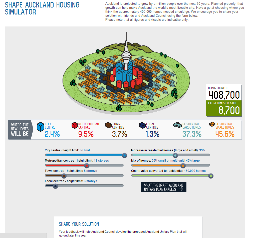
Auckland Council has developed a 3D model of Auckland to help develop the draft Auckland Unitary Plan.

This included modelling possible growth in 19 metropolitan and town centres around Auckland.

While largely an internal tool to help inform planning decisions, the resulting videos give a useful indication of how centres might grow over 10, 20 and 30+ years.

The model has this week come runner-up at the ALGIM GIS Project of the Year Award (Note: the winner was also from Auckland Council, its Capacity for Growth Study).

It’s important to remember that these are indicative only: clearly actual growth is down to what landowners decide to build and will of course be subject to design assessments. The videos demonstrate the protection of heritage buildings and show that high-rise buildings (9 or more storeys) will be restricted to metropolitan centres.

The videos can be viewed on youtube.com/aklcouncil and the 19 centres are:

Albany Botany Browns Bay Glen Eden Henderson
Highbury Manukau Manurewa New Lynn Newmarket
Otahuhu Papakura Point Chevalier Pukekohe Remuera
Sylvia Park Takapuna Three Kings Warkworth


You should be able click each of the individual centres above and see the video.


Of course as a reminder this shows the maximum development that could occur if economic conditions are right. Note the English carefully I have used as it is rather specific.


BEN ROSS : AUCKLAND

BR:AKL: Bring Well Managed Progress

The Unitary Plan: Bringing Change

Auckland: 2013 – OUR CITY, OUR CALL

Outline for Submission to Unitary Plan

My Submission to The Unitary Plan


As May 31 – the deadline to get in your feedback to the Draft Unitary Plan approaches, I have been slowly assembling all my bits and pieces and begun writing my submission for the Draft Unitary Plan a.k.a The Clunker.

However, with The Draft Unitary Plan covering some 1700 odd pages included 510 of those pages being large-scale maps it is near impossible by myself to comment on every single aspect of The Clunker. So I have narrowed down the submission to key points of interest to me in regards to wider Auckland.

Version 1.0 of my submission to The Draft Unitary Plan will cover thus far:

  1. Why I am covering the respective points here in this feedback document
  2. Brief recap on The Draft Unitary Plan as it currently stands
  3. 400,000 homes and one million people – where are they going to go?
  4. My Housing Mix using the shapeauckland.co.nz Housing Simulator
  5. The Zones: My Alternative to the Unitary Plan Zones using work from my Auckland Plan submission – this will include:
    1. Implementing the Centralised Master Community Plan (CMCP), the Semi-Liberal Plan Districts (SLPD), and the Municipal Utility District (MUD)
    2. Reworking the zones including adding, deleting, or modifications to the Unitary Plan Zones using zone definitions from my submission to the Auckland Plan
  6. Over Intensification with the centres – who gets upgraded and who gets downgraded. Also covered is redrawing the height restrictions imposed on some centres
  7. Manukau and St Heliers; special places deserve special recognition as one size does not fit all with the Unitary Plan
  8. CMCP’s and SLPD’s and applying them to select individual places in Auckland as examples of my alternative in regards to the Unitary Plan. Papakura and the Southern Rural Urban Boundary Greenfield sites will be two of the examples used
  9. The Rural Urban Boundary in Southern Auckland:
    1. Which of the three options per the Rural Urban Boundary Addendum
    2. Why I chose that particular RUB option
    3. How it would work (this will tie in with Point 8) and its effects to wider Auckland
    4. How it affects me personally
  10. Observed Transport issues stemming from the Unitary Plan. The Auckland Transport Integrated Transport Plan will be mentioned here
  11. Other infrastructure (including social) issues stemming from the Unitary Plan
  12. Any other notes and observations from the Unitary Plan
  13. Conclusion(s)

Urban design will be covered in multiple points rather than just one set specific point.


Even this is quite a bit to cover so I better get cracking with the writing. In the mean time I will continue my jet setting around the city participating and observing Unitary Plan community meetings (which I do have an opinion of as of current) and any more Civic Forums if they come up.


But for now I need to go book another holiday – I need it – or focus my spotlight back on my favourite crowd who must be wondering “What’s Up;” – Hehe Auckland Transport I am still here 😉


My Housing Mix from The Auckland Council Housing Simulator (Attempt One using Shape Auckland Housing Simulator)


What I came up with to give my take


Little Slice of (Green) Paradise

A Hidden Gem in Papakura


We (Rebekka and I) had discovered a hidden gem right here in Papakura while going about our daily walks. Tucked away behind a sports field near the SAS base is a little slice of (green (well brown because it is so damn dry)) paradise of open fields, trees and even a pond (well storm water facility). The park while tucked away is actually quite heavily utilised by local residents as they too go about their walks and/or give their dogs exercise. Here are some pictures of this hidden gem from when we went on our walk yesterday:


The park is a nice place and will be extra valuable as that new social housing development (as well as any other Green or Brownfield developments near by) takes hold and the families need somewhere to “relax” or “exercise” – seeming their tiny land sections won’t allow them.

I quite enjoy this hidden gem although it does need a spruce up from our Local Board.


Maybe a few benches, rubbish bins, a playground, and some trails wouldn’t go a miss to turn this gem into a shining gem for our local community?


So what hidden gems do you have in your community?

Mayor Supports South East Highway

Mayor Supports Redoubt Road – Mill Road Arterial


Last month in my “ROAD PLAN CONCERNS” post I had noted Auckland Transport‘s continued progress on moving towards the construction of the 4-lane “bypass” from the Manukau Motorway Interchange (with State Highway 1) along Redoubt Road, down Mill Road, around the back of eastern Papakura and reconnecting with State Highway One near Drury.

The respective post had a commentary piece from the NZ Herald as well as links to the Auckland Transport web portal on work thus far with this new four lane corridor plan. Also of mention was: the said corridor is both close to home (being in Papakura and five minutes away from the southern end of the soon-mentioned corridor) and I often use to skip-pass a section of the Southern Motorway when it backs up (usually in the afternoons) BR:AKL will take a look at the situation, then later on post an alternative proposal to the scheme.


Now I will resume working on that alternative proposal and will publish after my return from the Australian holiday starting next week. Work on the Manukau Rail North Link situation (which resulted in a compromise and win) as well as a pending mega project had taken much of my time recently however most of that is now finished (for now).


This morning however, I note Councillor George Wood picking up on comments from Mayor Len Brown (who lives 30 seconds from the said corridor) on his support for the corridor project.

From Stuff.co.nz

Manukau to Drury four-lane highway supported by mayor

SCOTT MORGAN

A four-lane highway that would connect Manukau with Drury has the backing of mayor Len Brown.

The Redoubt Rd-Mill Rd corridor needs land that is now occupied by homes and farms to progress.

Auckland Transport is finalising the route the $246 million first stage of the Redoubt corridor will take. It is an alternative arterial route to the southern motorway.

The road is expected to take more than 20 years to complete and has been subject to opposition from local residents’ groups.

Mr Brown has to declare a conflict of interest whenever decisions are made about how the project will move forward because he lives in the area.

“I’m in the way of it.”

But as leader of the city he supports the idea.

“It’s critical that we get this work done.”

There is a strategic need for the growing communities of Papakura, Alfriston and East Tamaki to be able to connect through the eastern side of the isthmus, he says.

Mr Brown says he is concerned about the effect plans for the 20-year project appear to be having on people’s lives.

But progress on new infrastructure needs to happen now, he says.

You can go see the rest of the article over at Stuff


But you can see the Mayor has thrown his support behind this large and long-winded project. With the corridor inching at a snail’s pace and seeming unable to be stopped in its entirety the next step (and I am aiming to try this through the alternative proposal) to mitigate against the worst of effects from the corridor and aim for a full integrated transport package.

More to come as it happens


Giving A Damn – About Auckland

For Auckland

Because I Live Here Too…


At 1400 hours today (2pm) I will be at the Manukau Civic Centre (the old Manukau City Council Building) giving my three-minute presentation then hopefully 7-minutes of dialogue with the four member Auckland Transport RPTP Hearings Panel.


The writing of submissions and showing up at hearings has basically become a “tradition” here since my first comprehensive submission (The Auckland Plan) in 2011. The question that begs to be asked is “Why?”


The answer is simple:

Because I live here too – and I give a damn about my home (Auckland) no matter what silly buggers Council can get up to 😛


So I thought I would show case some of my work over the last two years in participating widely in the democratic process on wanting and making Auckland a better place:


I will let readers know how the Regional Public Transport Plan presentation went later on today or early tomorrow morning


BEN ROSS : AUCKLAND

Shining The Light – To a Better Papakura (OUR home)
AND
To a Better Auckland – (OUR City)

Auckland 2013: YOUR CITY – YOUR CALL


RPTP Presentation

Ready, Set, Go for Presentation


Thursday 7th February at 1400 hours – Manukau Civic Centre I give my presentation to the Regional Public Transport Plan submission I wrote last year. I have finally completed the presentation for the four panel members which includes Councillor Mike Lee and AT’s Head of Public Transport Operations – Mark Lambert, with the main focus being local. That is the focus is close to home and covers the Manurewa, Takanini, Manukau and Papakura areas (I live in Papakura).

The presentation in PDF format is embedded below:


The speaking slot is only 10 minutes however if the panel members have read my written submission already AND paid some attention to the blog where most of the presentation material has come from, then the bulk of the speaking session should be a dialogue between myself and the panel members as they flesh out the points I have made. Not  spending time going over the entire submission as our AT panel members should have already read it (the presentation basically is a refresher with some graphics thrown in to illustrate points).


Transportation to the Hearing


Now being the Social Liberal that I am and having declared earlier that I am sensitive to price and time consideration when choosing a mode of transit, we shall take a look at the options I have to get me from Papakura to Manukau.


Basic Requirement
  • Presentation is at 14:00-14:10
  • Location: Manukau Civic Centre – Manukau City Centre (same area as Westfield Manukau Mall and Manukau Train Station
  • Must be at Manukau by 13:40 to hand presentation and notes for the panel members


To go by car to Manukau

Using the motorways it would take 15 minutes to travel the 11.1km trip – this is one way. As parking is free the main cost is petrol so I would say $3 for the return trip


To go by train to Manukau

According to the AT Journey Planner

Not even an option as the train into Manukau Station either at 1:04pm or 2:05 pm – so missing the market entirely as I would need to catch the 12:40pm service from Papakura and relay with the Britomart – Manukau train service at Puhinui at 12:56pm. Cost if I did decide to do this is $1 to the Park and Ride at Papakura and a $3 – 2-stage fare using my AT-HOP card (approx).

For the trip home providing I was not held up I would catch the 14:31 service from Manukau to Puhinui and relay with the 14:46 Eastern Line train heading to Papakura which gets in at Papakura at 15:03pm. Again cost is the same as the trip into Manukau


To use the bus

Not my first choice however I do have the following: Route 472 (so a Great South Road trundler) departing at 12:50pm and getting me to Manukau Mall at 13:15pm. Cost is $3.40 – two stage. Now the actual time consumer is the walk from the Manukau bus stop to the Civic Centre which takes another 10 minutes. So providing the bus was not late I would arrive at the Civic centre at 13:30 give or take.

Trip home would entail the following: Bus leaving (again the 472) 14:45 and getting to Papakura at 15:15 with the fare being $3.40.


So $3 and 25 minutes by car for the return trip, or over an hour and costing $8 approx for using a bus (trains do not even get a mention as the time is just too excessive to consider unless I really want to time waste).


I think CAR is the preferred choice for my trip to and from Manukau on Thursday; based on cost, efficiency and time. It shouldn’t be the case but it is – and now you can see why I am submitting to the RPTP so this situation should not happen!


Rather ironic isn’t it?