Some Answers on Papakura As a Metropolitan Centre Yesterday I posted on me heading to a Unitary Plan meeting on Papakura. The meeting was to cover Papakura … Continue reading Questions and Answers on Papakura

Some Answers on Papakura As a Metropolitan Centre Yesterday I posted on me heading to a Unitary Plan meeting on Papakura. The meeting was to cover Papakura … Continue reading Questions and Answers on Papakura
I must be a sucker for punishment rocking up to Committees regularly – especially Government ones. However need to keep the networks going, keep an eye on proceedings, and undertake some of that “dreaded” lobbying to advance projects for the benefit of others (Manukau South Link, or AT-HOP fares anyone?).
Next Wednesday (13 February) at 2pm (heck that is a late one) is the first Auckland Council Transport Committee meeting which is chaired by Councillor Mike Lee. You can see the agenda (part one and two) by clicking on the links in blue below:
I am heading to the Transport Committee meeting on Wednesday for various reasons – they include:
Any reaction to the Mainzeal collapse would be interesting as Council has gone more dead silent than a Soviet Missile Submarine off the American Atlantic Coast… This is especially as a public transport project that the Regional Public Transport Plan depends on (wrongly as it stands (another post – another day)) – the Manukau Interchange has stalled entirely.
Will keep you posted from the events of the Transport Committee meeting next Wednesday.
I have arrived back from my presentation to the Auckland Transport Regional Public Transport Plan hearings panel this afternoon. I am pleased to say that the full ten minutes plus two extra ( 😉 ) were productive and a dialogue entered on:
The presentation was designed in such a way that hyperlinks (in blue) were placed into the paper copies that allow the panel members or their assistants to look up ‘extended information’ (which is stored in this blog) on points I was making (the idea of the presentation was to sum up the main points and entered into dialogue – mission accomplished).
The presentation can be seen here:
After the presentation (actual) dialogue was entered to on two main points (there was a third point but that was me reinforcing the Manukau South Rail Link which by the looks of it has “a-lot” of support in South and Counties Auckland (basically everyone south of Manukau through to Pukekohe):
Walters Road and Spartan Road Stations
In my presentation I had emphasised the point on closing Takanini and Te Mahia Stations and relocating them to Spartan Road and Glenora Road (Walters Road is the rallying name). The two new stations would be equipped with facilities such as a bus interchange for feeder buses and Park ‘N’ Ride. The panel nodded away and picked up on the strong emphasis on the Park and Rides at all stations south of Manukau (basically). I was questioned on the Park and Rides and my belief of them being integral to a fully integrated transit system.
My answer was that I use the Park and Ride at Papakura and would do so at the Glenora (Walters) Road Station when built. I further went on and said the further away we get from the inner suburbs, the lower density housing we have, and we also have rural communities coming into effect as well. As a result feeder buses will do well up to a range of a 2km radius from a station (if run at a high enough frequency) but due to the nature of suburbia and all things rural south of Manukau (I was focusing on South Auckland); Park and rides extend the range of the station literally to an unlimited range.
For example a Park and Ride at Glenora Road would allow those as far as Clevedon to come in by car, park, and catch a train to town, Manukau, or even out west. A fully fledged Park and Ride at Pukekohe would allow (even more) residents from Waikau to come in by car then piggy back by train from Pukekohe to town and back again as happens now. Park and Rides also give maximum flexibility to bus or rail users that allow patrons to rock up to the station in their own time then continue the trip by bus or train (which is why I use Park and Rides). But at the end of the day feeder-buses, and Park and Rides both have their places especially as you go further out away from the CBD into suburbia and even more rural communities. This is the point I was bringing across to Auckland Transport this afternoon.
More on the station relocations can be found in my THE RAIL EFFICIENCY PROGRAM #5A post
This point took up most of the allocated time session in regards to dialogue between myself at the AT panel members. Councillor Mike Lee – who is also an Auckland Transport Board “Director” led the questions on the consequences of the scaling back on the availability of the rail Family Pass. The basic sum up of my answers can be found in my “FAMILY PASS HARD TO GET” post but basically the following was observed:
So the questions were asked, the answers given to AT in person for all to hear and transcribe.
Now it is a case of we wait and see what happens.
To me personally and above all else right now – having the Family Pass option installed on the Rail Ticket Machines would make me the most happy 😀
As I said – we now wait and see – but I have done all I can folks!
Thursday 7th February at 1400 hours – Manukau Civic Centre I give my presentation to the Regional Public Transport Plan submission I wrote last year. I have finally completed the presentation for the four panel members which includes Councillor Mike Lee and AT’s Head of Public Transport Operations – Mark Lambert, with the main focus being local. That is the focus is close to home and covers the Manurewa, Takanini, Manukau and Papakura areas (I live in Papakura).
The presentation in PDF format is embedded below:
The speaking slot is only 10 minutes however if the panel members have read my written submission already AND paid some attention to the blog where most of the presentation material has come from, then the bulk of the speaking session should be a dialogue between myself and the panel members as they flesh out the points I have made. Not spending time going over the entire submission as our AT panel members should have already read it (the presentation basically is a refresher with some graphics thrown in to illustrate points).
Now being the Social Liberal that I am and having declared earlier that I am sensitive to price and time consideration when choosing a mode of transit, we shall take a look at the options I have to get me from Papakura to Manukau.
To go by car to Manukau
Using the motorways it would take 15 minutes to travel the 11.1km trip – this is one way. As parking is free the main cost is petrol so I would say $3 for the return trip
According to the AT Journey Planner
Not even an option as the train into Manukau Station either at 1:04pm or 2:05 pm – so missing the market entirely as I would need to catch the 12:40pm service from Papakura and relay with the Britomart – Manukau train service at Puhinui at 12:56pm. Cost if I did decide to do this is $1 to the Park and Ride at Papakura and a $3 – 2-stage fare using my AT-HOP card (approx).
For the trip home providing I was not held up I would catch the 14:31 service from Manukau to Puhinui and relay with the 14:46 Eastern Line train heading to Papakura which gets in at Papakura at 15:03pm. Again cost is the same as the trip into Manukau
Not my first choice however I do have the following: Route 472 (so a Great South Road trundler) departing at 12:50pm and getting me to Manukau Mall at 13:15pm. Cost is $3.40 – two stage. Now the actual time consumer is the walk from the Manukau bus stop to the Civic Centre which takes another 10 minutes. So providing the bus was not late I would arrive at the Civic centre at 13:30 give or take.
Trip home would entail the following: Bus leaving (again the 472) 14:45 and getting to Papakura at 15:15 with the fare being $3.40.
So $3 and 25 minutes by car for the return trip, or over an hour and costing $8 approx for using a bus (trains do not even get a mention as the time is just too excessive to consider unless I really want to time waste).
I think CAR is the preferred choice for my trip to and from Manukau on Thursday; based on cost, efficiency and time. It shouldn’t be the case but it is – and now you can see why I am submitting to the RPTP so this situation should not happen!
Rather ironic isn’t it?
With added resilience now added into the Auckland rail network through crossovers at “major” stations and the Westfield Junction Fly-Over, attention now focuses in getting rail stations into the best strategic places as possible with the best “facilities” possible to attract and sustain high patronage numbers. Again some of the ideas about to be mentioned in these posts have been mentioned before, I am so-called “reposting” them here as I personally like the ideas and the fact they just need reposting to emphasis the point!
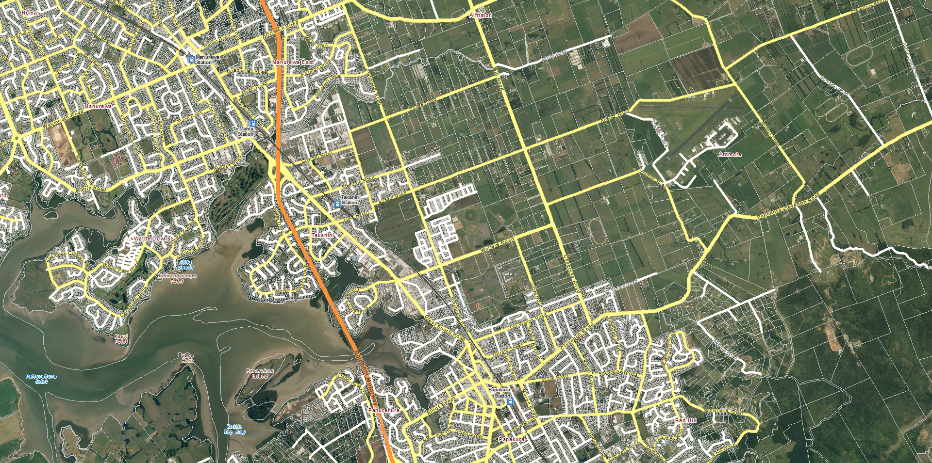
Currently on the Auckland Passenger Rail Network the station locations and patronage levels are somewhat scatty with some stations well placed and attracting patronage, while others do more of a disservice to network and can actually put people off using the network. Meaning some of our stations are not in the best locations and need to be moved to better suit the Auckland populace. There are currently three such locations – all on the Southern and Eastern Lines where the; removal, moving or adding of stations be considered doing in better enhancing the “catchment” and attractiveness of those currently or wanting to use our rail network. So lets take a look at the Southern and Eastern Lines starting from the south and moving towards Britomart.
No need to mention the adding of the Paerata and Drury Stations (complete with Park and Rides) as that is being currently covered in an extensive report by Auckland Transport which can be seen over at my PUKEKOHE ELECTRIFICATION CASE post. So moving along to the next section of the network that needs attention – which would be between Papakura and Manurewa Rail stations on the Southern/Eastern Line.
Click for full resolution

Again Click for full resoultion
Time to travel between stations currently:
Current Facilities and nearby Amenities at the stations currently:
Google Maps and the Council GIS viewer currently do not show the current stations in their current form, so until I make a trip down – no pictures as of yet.
So we have the situation with Te Mahia and Takanini Stations of what and where they are, and what state they are in. Now as I have alluded to earlier South Auckland is due to undergo significant urban growth per the Auckland Plan over the next thirty-odd years. The second graphic above had a red line drawn in it that show the extent urban growth can take during the life of the Auckland Plan – which means we could be looking at well over 35,000 new residences and businesses in the area over the next twenty years at least. Now putting two and two together (and disregarding Auckland Transport is apparently going to upgrade Takanini within the next five years – which I think is for the platform only (so no Park and Ride)) you have a situation of large urban growth near the rail corridor and two dilapidated stations that have bugger all facilities, bugger all catchment area, and bugger all future with little scope of being able to fully upgrade the stations with facilities like Papakura and Manurewa. So what do I propose?
Well I propose the following
In short I propose the following”
Why This?
These next round of graphics and annotations explain Spartan Road and Walters Road Stations
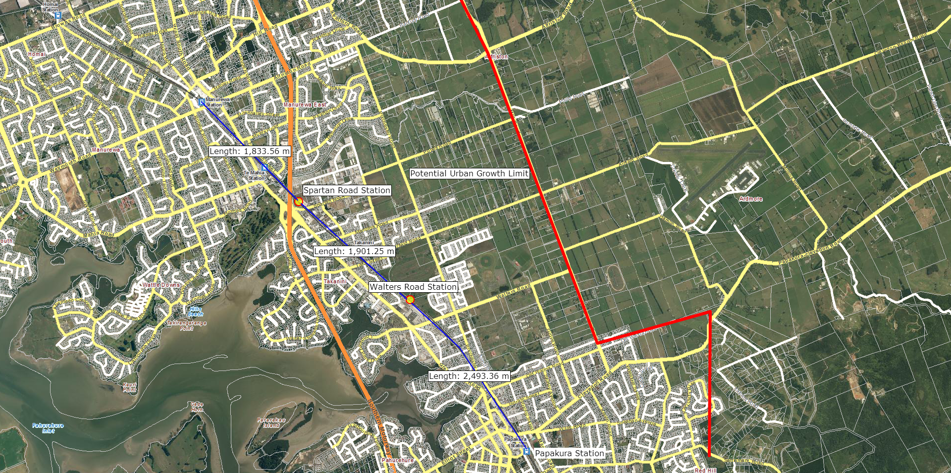
You can see where I have placed the new stations – close to current residents and business as well as future residents and business. Remember Te Mahia and Takanini Stations will be closed.

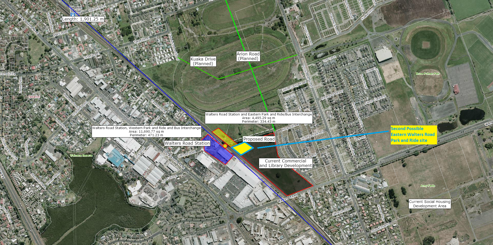
The size of land for the Station, Park and Ride, and Bus Interchange is just over 2 hectares in size. The brown lines show possible eastern shuttle bus connections for the station. A new proposed road linking Randwick and Spartan Road Station (via crossing the stream) is also placed. This new link would allow ease of access for residents to get to Spartan Road Station and possibly the industry in the surrounding area. Those living in the northern part of Conifer Grove (wedged between the Motorway, Walter Stevens Drive and Great South Road) have the choice of either Spartan Road or Walters Road Station.
Again click for full resolution
Walters Road is bit more unique in the fact it has technically two Park and Rides, as well as two bus interchanges – one on each side of the rail line (the sizes are 1.16ha and 0.44ha respectively). This would be owing to no road level crossing being built at the station site (we are trying to reduce level crossings) nor a road bridge being built that could be justified in the cost department. If the bus interchange and/or park and ride was only built on one side, it would me a 1.5km “detour” to get to the relevant side with the park and ride and/or interchange – a rather self-defeating exercise. Furthermore you would cause bottlenecks down Walters Road by buses and cars trying access the park and ride and/or interchange if it was built on one side only. To add further weight behind building a Western and Eastern Park and Rides + Bus interchanges is the fact that Walters Road would be a station serving a fast growing area being right next to a new commercial development and within easy reach of new residential development. The Western Park and Ride + Bus Interchange would service all residents and businesses on the Great South Road side of the rail line, while the Eastern Park and Ride + Bus Interchange would service residences and businesses between the rail line Mill Road (Red Line on first graphic). Also Papakura currently has two Park and Rides (one on the western side, one on the eastern side) which are both heavily utilised – so there is a very close by success story of building two Park and Ride facilities that would be utilised well. The Eastern Park and Ride + Bus Interchange would also be my new “home-station” where I would catch my trains from to head north.
One final note having Walters Road Station with its dual Park and Rides + Bus Interchanges; the area between Manurewa and Papakura East (Red Hill) is due to undergo significant urban growth over the next three decades. You are looking at tens of thousands of new residents as well as many new businesses and civic institutions for which Papakura Station (and Takanini for that matter as well) could no simply cope if we are looking at making mass transit accessible to our new residents. Takanini is a dunga and does not have the room for a large supporting facility (Park and Ride and Bus Interchange) to make any station upgrades viable. Walters Road Station (including Park and Ride and Bus Interchange) is bang smack in the middle of a catchment area that has existing residents and businesses as well as future urban growth. Walters Road Station would be on land that can support the required large-scale support facilities (Park and Ride and Bus Interchange) as well as being connected to two access roads that run both major arterial roads that can be or already are traffic light controlled for safety reasons. So in that sense getting Walters Road Station right is absolutely critical if it is to be a key lynch-pin station that would attract existing and new people to Auckland’s fully integrated mass transit network.
Varies significantly and I would need to consult both an engineer and a planner to find out the true construction costs as well as the Benefit Cost Ratio (BCR) factors and the works and operational effects on these four stations are significant.
The entire post is a justification on this project. The new running times would also most likely be the following (for diesels, running times for the electrics are unknown as of yet):
As what would happen to those who use Te Mahia and Takanini? For Takanini Station users two choices are available: car, walk, cycle, shuttle bus to either Spartan Road or Walters Road Crossing. For Te Mahia Station users they would use Manurewa or Spartan Road Stations and get there by car, shuttle bus, walk or cycle. So the alternatives are readily available and would present little disruption to existing users.
To build both Spartan Road and Walters Road Stations with their supporting facilities, the new road link bridge between Randwick and Westbrook Road (connecting to Spartan Road) and demolish both Te Mahia and Takanini would be an estimate of two years as Block of Lines (closing the network in that particular section) would be required.
And so while that is the Papakura – Manurewa section of station additions and removals there is one more on the Eastern Line before reaching Britomart that could be up for a move down the line. That be moving the current Meadowbank Station closer towards the Meadowbank Tunnel and renaming it Selwyn Station. But that I shall cover in the upcoming THE RAIL EFFICIENCY PROGRAM #5B post.
But in the meantime what do you think on basically moving two stations to better locations and adding support facilities such as Park and Rides, and Bus Interchanges. Comment below
*Note: To make it clear; when I refer to Park and Rides I also mean including Kiss and Ride as well as Cycle Lockers as part of the Park and Ride Facilities.
We all know housing affordability in Auckland sucks with the Demographia Affordability rating being around 5.3 or “severely unaffordable (affordable is at 3.0 meaning the total cost of a home purchase should not exceed three times the total annual income of the household living in it. Currently Rebekka and I sit around the 3.52 mark). All sorts of measures are trying to be taken to allow the average person to at least being able to afford their very own house to live in. In this particular case Housing New Zealand has put out a tender to the private sector for the construction of upwards of 500 new homes that are: state houses, social housing and full private houses. The NZ Herald explains:
From the NZH:
Big low cost homes job set to start
5:30 AM Friday Oct 12, 2012
Housing New Zealand is seeking a private partner to build houses on former Papakura army camp land.
Earthworks for Auckland’s biggest low-cost housing development in 25 years will start next month on land that used to be part of the Papakura army base.
Housing New Zealand is seeking a private sector partner to build between 450 and 500 homes on the 24ha site between Walters Rd and McLennan Park. Tenders close on October 16.
Its general manager of asset development, Sean Bignell, said the homes would be a mix of 10 per cent state houses, 20 per cent other social housing and 70 per cent for private sale at prices likely to be “in the high 200s to the high 300s” – putting most of them below the lower quartile mark of Auckland residential properties sold this year.
Finance Minister Bill English said recently that high land prices had skewed Auckland builders towards large, high-value houses, and there was “no housing being built for people in the lowest quartile of income”.
“That is clearly unsustainable,” he said.
A start on the Papakura project comes as Housing NZ bows out of another long-planned 10ha development next to the Weymouth child welfare home, which the new Social Housing Unit in the Ministry of Business, Innovation and Employment has allocated to “third-sector” social and affordable housing.
If you want to know where approximately, check the map below

Click for full resolution
So between 450-500 new houses are to be built in the vicinity to where I live. Hmm means its going to be noisy and dusty for a while but I am not particularly minding too much. Look we need more “affordable” housing and if Housing NZ can take the lead in offering this affordable housing then so be it. If I was to have any concerns it is not around the fact “low-cost” housing is about to be built in my backyard; my concern is around the urban design factor which sets the future for this large-scale project for life.
I assume the houses will be a mix of 2-4 bedrooms on sections between 400-600m2? I need to go hit up my Local Board and take a look at the plans as they are not easily found online at the moment. The plans would tell me what kind of urban design work is being done and whether the urban design method chosen will be a benefit or a total hindrance to the future of this development. And something tells me the urban design of this development is actually going to be a hindrance more than a benefit here. How so?
Quick crude maths tells me the following:
If we want the kids to at least have a decent backyard to play in and maybe grow the vegetable garden as well (although that is a lost art in Auckland) I would suggest 450m2 sections for three and four bedroom houses would be a generous and comfortable size. Anything smaller and we get no yard space for the kids and that can generate problems if there are no parks nearby. And no Bruce Pulman Park does not count unless you want to cross a very busy Walters Road while the McLennan Park is often used for sports. From what I have also gleamed from the graphic for this new development, thankfully the roads inside the new development are grid which promotes easy of traffic (foot and vehicle) flow while mitigating against the Fear of Crime perception that often comes about in urban development. However there are only two ways in and out of the development (so connecting to main roads) which could be a bit of a pain and isolating factor to this new development. In fact the lack of access to the main roads could isolate this new development and lack of accessibility can mean crime can fester inside the development.
In all that regard, I am going to have to go take a look at the plans to see what is exactly proposed. As I said nothing wrong with new development even in my backyard (I knew things like this would happen in Papakura when we chose to move here), but piss-poor urban design that turns this much needed housing into a crime-bed will not go down particularly well with me.
Now as for public transport access. This development is somewhat isolated from the main bus network which runs up and down the Great South Road. Rail-wise you have Takanini and Papakura Station both within 5-minutes of each other although 450 new houses will put pressure on Papakura’s existing Park and Ride which is already short of spaces. This new development would be the perfect time for Auckland Transport to haul arse and get the new Walters Road Rail Station along with a Park and Ride (with 450 spaces) and shuttle bus bay to serve Papakura north, Addison, Takanini east and the new development soon to be built. Trying to encourage public transport with Walters Road Station and Park and Ride would be a good start in improving public transport accessibility, especially for our new residents soon to move in.
Papakura Local Board as well as myself support and are advocating to AT on the Walters Road Station, this new development PLUS the continued development of Addison would be the perfect catalyst into getting our new station by 2015!
I have written in previous submissions as well as the current submission I am writing (the AT Regional Public Transport Plan) for the construction of Walters Road Station, and am making it an election campaign pledge to continue to have the station built sooner rather than later in the Local Government Elections next year!
But in the mean time, I shall go search those plans for this new development.
