
Relief value for Auckland
Yesterday I gave a guest lecture to Environmental Planning at the University of Waikato on inter-regional planning and sustainability. My thanks to Professor Iain White for the opportunity to guest lecture.
The lecture built upon a blog post I did recently on inter-regional planning. You can see the full post at the bottom of this post.
The main points of the lecture:
- Cities and provinces since the 1990’s have been in competition
- Rapid urbanisation and globalisation has seen the provinces hollowed out when industry has moved to Auckland
- Auckland houses 37% of GDP and 34% of the population while growing at 800 new residents a week, this is unsustainable
- Infrastructure both in terms of transport and water are not coping
- Record suicide rate of 606 for the year in part will have come from Provincial centres being hollowed out and no real chances of employment available
- Inter-Regional Planning connects up the smaller Centres with the bigger Centres spreading the population and employment load. Acts as control rods for Auckland
- Tourism potential
The lecture slides can be seen below:
The presentation drew on my earlier Inter-Regional Planning post as seen below:
Regional Rapid Rail, Inter-Regional Planning, and a Planning Ministry. Transforming and Unlocking Places
Regional Rapid Rail opens up opportunities
Greater Auckland’s Regional Rapid Rail has certainly opened the discussion on rebuilding the regional rail network across the upper North Island.
From Greater Auckland:
Introducing Regional Rapid Rail
This post gives you a brief summary of our staged proposal to introduce higher speed inter-city rail to the Upper North Island. The full plan and the detail behind it can be seen in Regional Rapid Rail Report (8mb). This document looks amazing thanks to the design genius of Cornelius from Frontier for the design – who is also behind our website and the CFN 2.0 Report. You can also see a more detailed version of the maps for Stage 1, Stage 2, and Stage 3. Feel free to download, print, distribute, draw on, set alight, decorate your room, or re-blog, just remember to cite!
Why Regional Rapid Rail?
The “Golden Triangle” of Auckland, Waikato and the Bay of Plenty now make up over 50% of New Zealand’s population and are expected to account for over 70% of New Zealand’s growth in the future. If we fail to provide the necessary infrastructure, we will miss out on many of the benefits from this coming growth.
We need to provide a step change in intercity transit to leverage this growth proactively, rather than reactively waiting for it to congest the Waikato Expressway and Auckland’s Southern Motorway. With the Waikato Expressway almost complete, what is missing is the maximisation of the complementary rail corridors.
We have the opportunity to create a well-planned, integrated Upper North Island transport system– one that is able to deliver strong economic and social outcomes, including regional development, not just for the area but for New Zealand as a whole.
Regional Rapid Rail will revitalise the existing rail network using modern technology tilting trains travelling up to 160km/h on upgraded tracks. This will allow for much faster trains, providing quick and reliable journeys that are faster than driving and skip the traffic completely. This revitalised network will stitch together the economy of Auckland, Hamilton and Tauranga, and extend the benefits of growth and development of the main centres to their nearby towns and villages. This will provide fast and reliable travel options to regular commuters, business travellers, shoppers, students, local visitors and international tourists alike.
However, Regional Rapid Rail isn’t just a scheme for commuter trains on the trunk line. It is an integrated regional economic development plan for the Upper North Island, based on fast and regular intercity train connections between the cities and towns of Auckland, the Waikato and the Bay of Plenty.
The proposal has four pillars for success:
- Using the right technology to achieve speed and performance affordably
- Leveraging existing infrastructure
- Providing a frequent, reliable and regular service for all trip types
- Integration with land use and development plans
Strategic Goals
The specific objectives of Regional Rapid Rail are to:
- Connect major employment and population centres, including central business districts, growing metropolitan areas, employment areas and satellite towns in the Upper North Island.
- Deliver a fast and competitive rail service with a target travel time of 90 minutes from Hamilton to Auckland and under 2 ½ hours from Tauranga to Auckland. The emphasis is on quality of time and maintaining consistent and reliable speeds.
- Provide a regular and frequent rail service, scheduled to suit a range of travel times and trip purposes, serving commuters, tourists, students and residents alike.
- Make complementary improvements to the rail freight network. All upgrades should, at the least, not disturb KiwiRail’s ability to move freight now or in the future. Passenger rail network upgrades should also seek complementary improvements that also enhance the efficiency and capacity of the Kiwirail rail freight network.
- Assist the creation of affordable housing supply that is well connected by congestion-free transit. Use transit focused residential development to catalyse the local economies of northern Waikato towns, which face potential economic decline by being bypassed by the new Waikato Expressway.
- Link regional transportation to well-planned communities with good urban outcomes. This should not just be a rapid train network but the means to create vibrant, livable towns and cities that are economically and socially sustainable.
- Integrate directly with local public transport, walking and cycling networks, such as the Congestion Free Network 2.0, to maximise coverage and usefulness.
- Deliver environmental benefits by limiting the growth of long range traffic and reducing pollution and CO2 emissions, assisting New Zealand to meet its commitments under the Paris Agreement.
- Reduce road traffic injury and deaths, to assist New Zealand in reaching Vision Zero.
- Ensure value for money for taxpayer investment by optimising investment in infrastructure where it is most effective, regardless of mode.
………
Source: https://www.greaterauckland.org.nz/2017/08/17/introducing-regional-rapid-rail/
Here is the diagram on where the Regional Rapid Rail would go:

This is how it looks when population is taken into account:

Travel times:
- Auckland to Hamilton
- 90 minutes with stage two
- 70 minutes with stage three
- Auckland to Tauranga
- 2:30 hours with stage two
- 2 hours with stage three
- Auckland to Papakura with the EMUs
- 53 minutes pre City Rail Link
- 43 minutes post City Rail Line
- Auckland to Hamilton by car
- 90 minutes
- 60 minutes from Papakura
- 70 minutes from Manukau
Note: Auckland = Britomart Station or Hobson Street On-ramp
It should also be noted the car travel times will get longer as population and traffic increases on the Southern Motorway and Waikato Expressway.
I am not here to go over Greater Auckland’s time and dollar figures as they have done that extensively over at their place. Here I am going to look at the Urban Geography of the Regional Rapid Rail and how it promotes connectivity across the upper North Island.
The Urban Geography of the Regional Rapid Rail and how it promotes connectivity across the upper North Island
Over the years I have blogged and presented materials on inter-regional planning (and how authorities don’t quite get it). The central themes around this inter-regional planning are the following:
- Most urban growth both residential and industrial will be in Southern Auckland
- Industry is decamping from the Southdown-Onehunga complex and moving into Southern Auckland as land use competition with residential and commercial heats up on the Auckland Isthmus
- Heavy industry seeks out lower land values with good connections and little land-use competition as mentioned above
- Population is spilling out of Southern Auckland and like industry will see provincial places in the northern Waikato
- State Highways 1, 2 27 and 29 form the road spines while the North Island Main Trunk Line and the East Coast Main Trunk Line form the rail spines between Auckland, Hamilton and Tauranga
- The Golden Triangle forms 50% of the national population and 50-60%% of national GDP
- Role of Manukau City Centre into the future
As Auckland continues to boom satellite towns like Pokeno, Huntly and Morrinsville will reestablish themselves especially as the other major centres (Hamilton and Tauranga) continue to become major satellites to Auckland. The good thing is those places are on both established road and rail links making their connectivity back to Auckland rather straight forward. Cue the Regional Rapid Rail concept linking the smaller and larger satellites back up to Auckland.
Population load spreading – saving the Provinces and Auckland at the same time
Rapid urbanisation has seen provincial centres without decent industry hollow out while the main urban centres continue boom and expand. This is not healthy for either and can create imbalances both economic and social that impair the economy. Whether industry moves to the provincial centres or not population load spreading (that is Auckland loses some of it population to its Satellites in the south) can act as a control rod to the reactors that are our major urban centres. As noted it above Auckland to Hamilton would be 70 minutes so being in a provincial satellite between Pokeno to Te Rapa connected to the Regional Rapid Rail allows for some Aucklanders to move while still having good connectivity with their employment back in the City. If Manukau City Centre and its big industrial complexes step up then a commute from Huntly to Puhinui or Manukau becomes even shorter.
If a smaller satellite is not for you then Hamilton or even Tauranga is always available for you to live while being connected back to Auckland via the rail system.
So yes Regional Rapid Rail connecting up both the main urban centres and the provincial satellites can give pressure relief to Auckland through population spreading.
Employment and Industry spreading
Like with population rapid urbanisation consolidated heavy industry away from small towns and into the big urban centres gutting those smaller towns. Projects like the Waikato Expressway will bypass and further harm these towns (like Huntly) so enter rail to turn things around.
Remember:
- Assist the creation of affordable housing supply that is well-connected by congestion-free transit. Use transit focused residential development to catalyse the local economies of northern Waikato towns, which face potential economic decline by being bypassed by the new Waikato Expressway.
….
Source: Greater Auckland
Heavy industry as Auckland continues to expand will seek out places where land-use competition is not intense. Smaller provincial centres connected up by decent passenger and freight rail would be in the box seat to receive these industries as they move around. But it is not only big industry on the move. As the population load spread ramps up niche industries and commerce will follow and set themselves up in the provincial centres connected by Regional Rapid Rail. This has two positive consequences:
- Smaller urban centres increase their local employment base
- Diversified employment base better protects the smaller centres from the fluctuations of the economy
Niche industries can include tourism which is next up.
Tourism
Two hours to Tauranga by train. I will certainly take that on a Friday evening returning to Auckland late Sunday or early Monday when taking a weekend away from Auckland compared to the two and a half hour drive by car I will have to do next month by car. Play the cards right and you could have a premium service going down on Friday and returning Sunday that serves food and well booze for a slightly higher fare. This would tap into the large tourism potential Tauranga offers but the smaller Centres connected by Regional Rapid Rail need not miss out. Rotorua, Cambridge, Waitomo and even Huntly should be able to tap into niche tourism offerings of various sizes that the rail system would allow.
Again diversifying your employment base gives you as a smaller centre better protections from the swings of the economy.
Productivity and environmental impacts – transforming and unlocking places!
Heavy Rail is the most efficient form of moving people and goods over long distances compared to road travel. Whether it be lower emissions, able to do work on your laptop, relax on the trip or simply beat congestion on the Southern Motorway productivity and (lesser) environmental impacts are winners from Regional Rapid Rail. Of course lowering the road toll (which costs the economy dearly) is another outcome of providing rail alternatives whether freight or passenger.
A rail corridor also has less environmental severance than a four lane highway does as well as less scaring. So not only does rail promote productivity and encourage lower emissions while travelling, rail also is less visually destructive to the rural environment than a four lane highway.
But the impact that might not be realised as quickly is the transformation and unlocking of potential for the Centres connected to Regional Rapid Rail network.
Being able to connect up to the large residential, employment and industrial base in Southern Auckland (let alone the rest of Auckland) opens up both the larger and smaller urban centres connected to the Regional Rapid Rail Network to opportunities not currently available. No matter what niche a provincial Centre takes up being able to be connected to a large population, employment and/or industrial base would allow those Centres to unlock their full potential and transform themselves through:
- Linking regional transportation to well-planned communities with good urban outcomes. This should not just be a rapid train network but the means to create vibrant, livable towns and cities that are economically and socially sustainable.
….
Source: Greater Auckland
Vibrant places are productive and environmentally positive places.
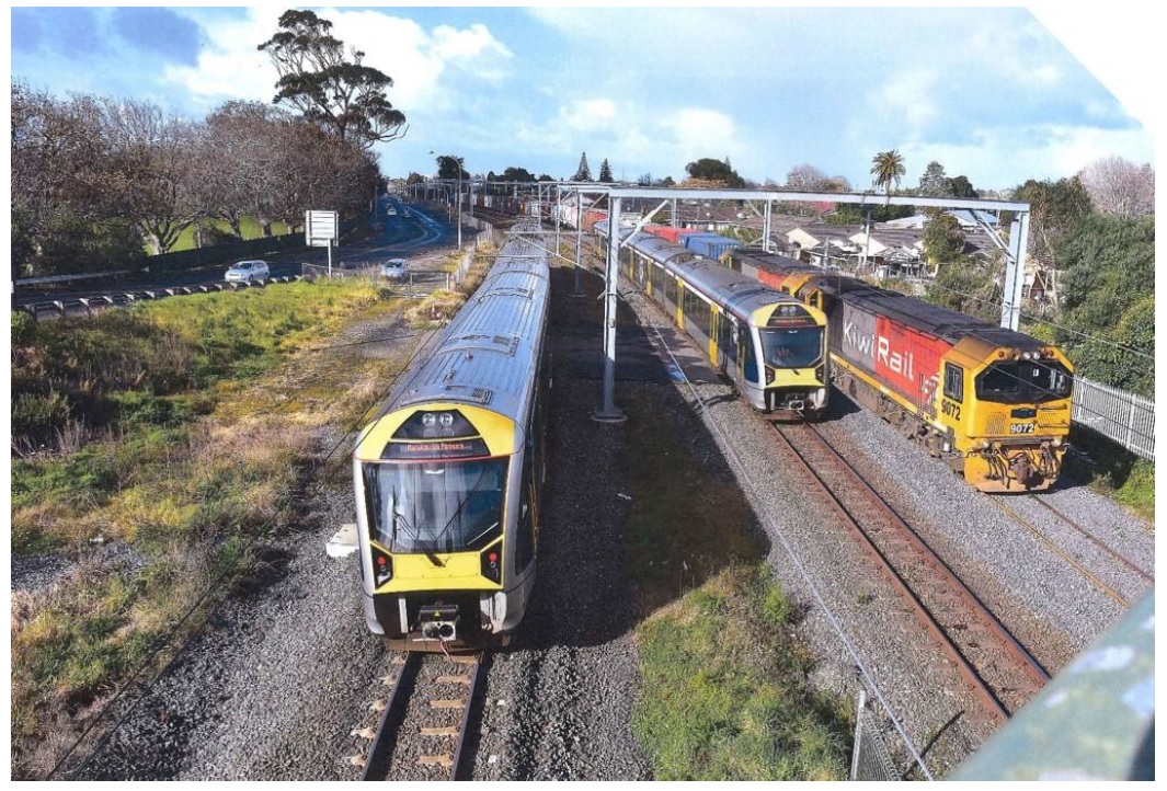
The Southern Airport Line, Puhinui Station and Auckland International Airport
Auckland International Airport is the gateway to the world in terms of air travel. Currently the only way to get there is to drive or catch a regional link flight which are not cheap at the best of days. Enter The Southern Airport Line and Puhinui Station.
The Southern Airport Line is a rapid transit link (most likely light rail) from Manukau to the Airport via Puhinui Station that connects up with both the commuter rail/bus services and the Regional Rapid Rail lines. This means you could catch a train from the Waikato or Tauranga up to Puhinui Station, transfer to the Southern Airport Line at Puhinui and continue on a second train to the Airport without the hassle of driving or arranging van shuttles (subsequently risking fouling of any of the State Highways on the way to the Airport). Like wise you or tourists can do the same in return by catching the Southern Airport Line to Puhinui then catching a regional rail service down to your destination without having to worry about shuttle vans and rentals (until you get to your destination if so inclined). A good option especially if coming off a long flight.
Of course this would mean Puhinui Station would need to double in size to four platforms while both the Third and Fourth Mains would also need to be built to facilitate the high volume of freight and passenger traffic in the area.
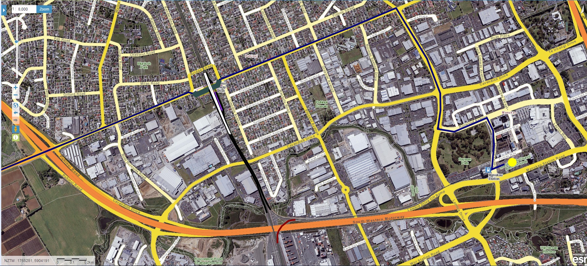
The good news is The Southern Airport Line is already committed to and should be open by 2020. The Third Main from Westfield to Papakura is also committed to while the Fourth Main from Otahuhu to Wiri is being lobbied on to make it happen.

Regional Rapid Rail and The Southern Airport Line: seamless travel to and from the Airport no matter where you are in the upper North Island.

Speaking of The Southern Airport Line
Regional Rail, The Southern Airport Line and Manukau City Centre
This next bit of urban geography doesn’t immediately stand out but it is a crucial one. This one links to the RRR’s first principle of:
- Connect major employment and population centres, including central business districts, growing metropolitan areas, employment areas and satellite towns in the Upper North Island.
……
Source: Greater Auckland
Major employment centre: Manukau City Centre and its industrial complexes that generation 20% of Auckland’s GDP or 7.4% of national GDP (the main City Centre also generates the same as a comparison)
Major population centre: All of Southern Auckland as it currently houses 38% of Auckland’s population and due to hit 45% in 2040
Benefit: Both connected by the rail line and State Highway One into the Waikato and Bay of Plenty

Now let me get this perfectly clear: the main City Centre has its place and will be the nexus of commercial and civic activity for both Auckland and New Zealand. That said it does not dismiss the role of a smaller and secondary City Centre surrounded by industrial complexes in filling a need for the Waikato and Bay of Plenty.
Let’s take a look at how Panuku Development Auckland sees Manukau and its relationship with the Waikato and Bay of Plenty:

Note the Golden Triangle mentioned with Manukau acting as the key gateway.

As you can see Manukau does act as a gateway to the Waikato and Bay of Plenty. Regional Rapid Rail, and the Southern Airport Line (both to the Airport and Manukau) connect the Waikato and Bay of Plenty to both major employment and population centres. If the main City Centre is not for you or you need an industrial base Manukau and Southern Auckland has probably what you are looking for.
If Regional Rapid Rail gives you 1:10 hours from Hamilton to Britomart (City Centre) and 2:00 hours from Tauranga to Auckland then these are the estimate times to Manukau or the Airport via the Southern Airport Line including a maximum five-minute transfer window:
- Hamilton to Manukau or the Airport: 1 hour
- Tauranga to Manukau or the Airport: 1:40 hours
Effectively Manukau becomes the core to both Southern Auckland and the those in reach of the Regional Rapid Rail.
Planning Ministry
Normally the Ministry of Transport would oversea the execution of the Regional Rapid Rail program and the Southern Airport Line program. However, given the consequences to the urban environment brought on by those urban centres connected to the RRR the Ministry of Transport is not best set up to handle the mechanics of both programs.
Enter the Planning Ministry
The Planning Ministry borrows its concepts from New South Wales.
From the Department of Planning and Environment – NSW:
We exist to make people’s lives better by making NSW a great place to live and work. We help to provide homes and services, build great communities, create jobs and protect the environment.
……..
The Department engages place making which includes transport and the same principle would be applied here with a Planning Ministry. That is the Planning Ministry would draw up the overall inter-regional planning framework and be the overseer to all other agencies executing the planning framework including Regional Rapid Rail, and The Southern Airport Line. The Planning Ministry would be your one stop shop for transport urban and economic planning, environment management, and plan/place maker.
The Planning Ministry would break down silos that would have otherwise occurred between the Ministry of Transport and the wide range of Councils involved with the Regional Rapid Rail Scheme.
In conclusion and some 3,000 words later the Urban Geography of Regional Rapid Rail is just more than pretty lines on a map and trains going between Auckland and somewhere south of the Bombays. Whether it is for tourism, diversifying employment bases in provincial centres or allowing population loads to spread from Auckland south Regional Rapid Rail presents those opportunities more than four lane highways ever could.
That said to make sure it is done right a Planning Ministry would be needed to oversee the multi-discipline approach that not only delivers transport links but also economic and placing making as well.
It is all about tapping into the potential of the urban centres both Auckland and those in the Waikato and Bay of Plenty.

Source: Greater Auckland
……………………………….

