
Making most of the situation
There seems to be a bit of movement with Light Rail as Auckland Transport and Greater Auckland make the case for the Northern Airport Line (Airport to the City Centre via Dominion Road).
From Auckland Transport:
Light rail
Auckland Transport (AT) and the New Zealand Transport Agency (NZTA) agree to progress light rail for Auckland to urgently address Auckland’s growing congestion and accessibility problems.
Project status: Investigation
Project zone: Central
Project overview
AT recognises the need to urgently address the worsening congestion and accessibility problems in Auckland. We continue to assess high-capacity public transport solutions that can ease congestion and provide more transport options to help make Auckland a more modern, sustainable, connected, progressive, globally-competitive city.
Our own research and analysis, as well as global case studies, show that light rail can be both a solution and a catalyst. It has great potential to improve amenities, develop communities, provide access to jobs and education and attract investment. It will support Auckland as a forward thinking, sustainable, connected, and globally competitive city.
Why Auckland needs light rail
Auckland is growing, bringing diversity, vibrancy and opportunity. But growth also brings big challenges: such as current public transport reaching capacity, rising land costs, and increasing congestion. These affect our quality of life and productivity, as well as visitors’ experiences and our ability to host world-class sporting, business and cultural events.
Benefits
Light rail for Auckland is not just about reducing traffic congestion. It’s also about unlocking our City’s potential. The certainty of permanent infrastructure creates better connected neighbourhoods where people want to invest in building housing and amenities. When we improve our public transport, our city as a whole benefits, not just people using public transport:
- Growth potential. Permanent infrastructure like transport hubs supports urban development, increased productivity, and economic growth.
- Moving people. Based on its route and frequency, light rail will get more people where they need to go – to work, home, education and leisure.
- More capacity. Each 2-carriage, 66-metre light rail vehicle carries up to 420 people, compared to 180 double decker bus passengers in 2 buses and only 10-12 car users in the same space.
- Better frequency. You don’t need a timetable, simply turn up to a stop, as a light rail vehicle will be along approximately every 5-10 minutes.
- Service reliability. Light rail’s traffic signal priority and dedicated tracks make reliability close to 100%.
- Sustainability. Light rail vehicles will be electric, meaning zero emissions operation. Better public transport options mean fewer private vehicles on our roads – reducing Auckland’s carbon footprint.
- Airport access. This will support regional and national business and tourism, as well as employment and residential accessibility for this growing precinct.
- Problem solving. Light rail addresses bus congestion in the city centre and commute times along Dominion Road (New Zealand’s busiest arterial corridor).
- Better access. Light rail will support lower socio-economic neighbourhoods along its route by improving access to and from work and study, and attracting investment in infrastructure and amenities.
- Room to move. Light rail’s capacity, frequency and reliability will encourage more Aucklanders out of their cars, creating more space on our roads for all users, including private vehicles.
Project details
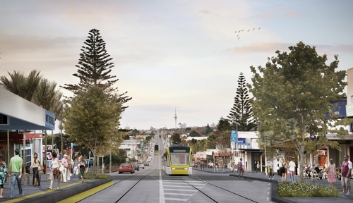
Light rail is like a tramway, but runs on its own dedicated right-of-way. This means it’s not affected by traffic speeds. In Auckland, light rail would have fewer stops than buses, but the service would be more frequent and travel faster than buses. Light rail vehicles also have much greater capacity than buses and cars.

Source: https://at.govt.nz/projects-roadworks/light-rail/
And from Greater Auckland:
Build Light Rail right – Close the centres to cars
………
Share the placemaking love
One of the aspects I’m most looking forward to with light rail is in the city where Queen St will be turned into a pedestrian friendly transit mall. This will not only help light rail to glide through the city easier, but will also provide a lot more pedestrian space for the tens of thousands who walk along the street every day. It’s something that’s long overdue and could look similar to what’s being installed in Sydney on George St.

But why should the city centre to be the only location to benefit from such dramatically improved people space? The town centres on Dominion Rd would all benefit significantly from similar treatments by helping to make them into more unique destinations. Destinations that could also support a lot more people visiting and walking thanks to the building of light rail.
Parking is obviously going to be an issue that many focus on but it’s worth noting that it is likely to be removed whether there is vehicle access or not, there simply isn’t space for it. The road corridor through the town centres is too narrow and widening it isn’t an option.
The one major benefit that the current on-street parking provides is that outside of peak hours, it gives a bit of a buffer between the moving vehicles and pedestrians. With light rail having dedicated lanes and by retaining through traffic, it will mean moving vehicles right up against the footpath at all times. Not the most pleasant pedestrian environment.
As I understand it, there is one exception to this and that is where the stops are located. Due to the narrow corridor, at that those locations the plan is to build out the stops into the traffic lane. This is shown in one of the images from ATs light rail page. As you can see, the road is narrowed but then expands back out to accommodate the traffic lanes.

This of course raises questions about the next point …..
Give Light Rail the priority it deserves
AT have repeatedly said that light rail will be separated from traffic, such as this statement from their website.
- Service reliability. Light rail’s traffic signal priority and dedicated tracks make reliability close to 100%.
and ….
Light rail is like a tramway, but runs on its own dedicated right-of-way. This means it’s not affected by traffic speeds
This raises the question of how those statements are able to be squared off against the images above. As I understand it, the plan is for vehicles and light rail to share the space in the town centres but be separated by time. In other words, when a light rail vehicle (LRV) approaches the town centre/stop, cars will be prevented by lights from driving through. If you look closely at the image above, you can actually see this with a light pole and intersection limit line just to the right of the LRV.
We think this is a poor solution for two key reasons.
- Drivers don’t always behave like they’re meant to. One only needs to look at busy intersections to see impatient drivers entering an intersection and then blocking it when the light changes. Leaving the success of the project up to the behaviour of Auckland drivers is not something I’d risk.
- AT say there will be service every 5-10 minutes but over time, and especially after it reaches the airport, we’d expect this to increase. Even if drivers behave perfectly like AT expect, that will mean the town centres will be closed for a lot of the time anyway. It’s also worth remembering that unlike other intersections, the light rail isn’t just passing through but it’s also stopping at a station. All up it could well take a minute or more for the LRV to clear the section, during which time no through traffic is moving anyway, and another LRV might only be a minute or so behind to repeat the process.
……….
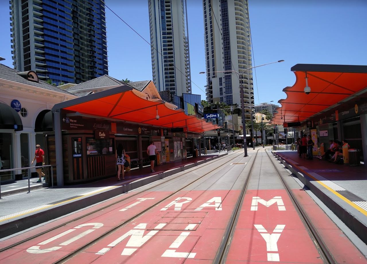
Closing town centres to traffic to enable light rail isn’t uncommon in many overseas systems either. Over on the Gold Coast, traffic through Surfers Paradise has been reduced to one lane only in places. Traffic in the other direction needs to find another route.
……………
Source: https://www.greaterauckland.org.nz/2018/01/19/build-light-rail-right-close-centres-cars/
I couldn’t agree more in sharing the love. What about Light Rail to and through our largest Metropolitan Centre – Manukau?
Light Rail to the North Shore and Light Rail to Westgate Metropolitan Centre via the North Western Motorway both run primarily along their respective motorways or State Highways to their end destinations leaving transit orientated type developments limited. The two places that might get something is Takapuna Metropolitan Centre where the North Western Light Rail Line might end in one direction and Westgate Metropolitan Centre at the other end of the said line.
Source: Greater Auckland
The Southern Airport Line from the Airport all the way to Botany or even Howick however, has opportunities for transit orientated developments and new micro Centres (some within a larger Centre) at pretty much each station along its route. This presents a very rare opportunity to share some Northern Airport Line love with its Southern Airport Line twin and get all the benefits the North does for the South:
- Growth potential. Permanent infrastructure like transport hubs supports urban development, increased productivity, and economic growth.
- Moving people. Based on its route and frequency, light rail will get more people where they need to go – to work, home, education and leisure.
- More capacity. Each 2-carriage, 66-metre light rail vehicle carries up to 420 people, compared to 180 double decker bus passengers in 2 buses and only 10-12 car users in the same space.
- Better frequency. You don’t need a timetable, simply turn up to a stop, as a light rail vehicle will be along approximately every 5-10 minutes.
- Service reliability. Light rail’s traffic signal priority and dedicated tracks make reliability close to 100%.
- Sustainability. Light rail vehicles will be electric, meaning zero emissions operation. Better public transport options mean fewer private vehicles on our roads – reducing Auckland’s carbon footprint.
- Airport access. This will support regional and national business and tourism, as well as employment and residential accessibility for this growing precinct.
- Problem solving. Light rail addresses bus congestion in the city centre and commute times along Dominion Road (New Zealand’s busiest arterial corridor).
- Better access. Light rail will support lower socio-economic neighbourhoods along its route by improving access to and from work and study, and attracting investment in infrastructure and amenities.
- Room to move. Light rail’s capacity, frequency and reliability will encourage more Aucklanders out of their cars, creating more space on our roads for all users, including private vehicles.
……
That being from Auckland Transport as mentioned earlier on
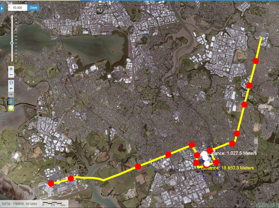
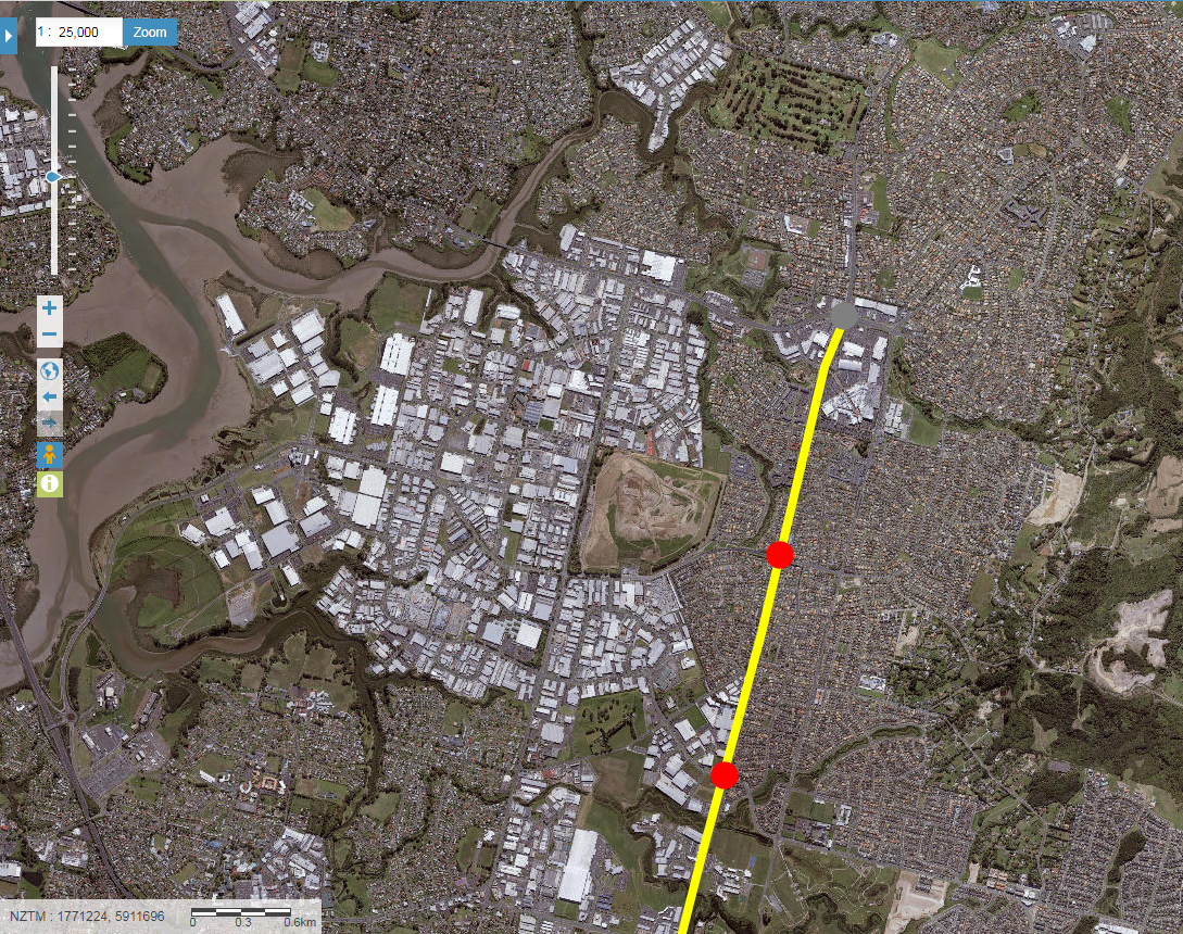
The path of the Southern Airport Line
First of let’s see where Auckland Transport are looking to run the Southern Airport Line (bus or Light Rail):


I don’t like the path as it goes through Manukau (see: Trans City vs Local District Transit. #CitiesSkylines Lessons for Auckland) so I have come up with something better.
First the overview of the Southern Airport Line (Airport to Botany):


In relation to the Unitary Plan zoning for Manukau City Centre:
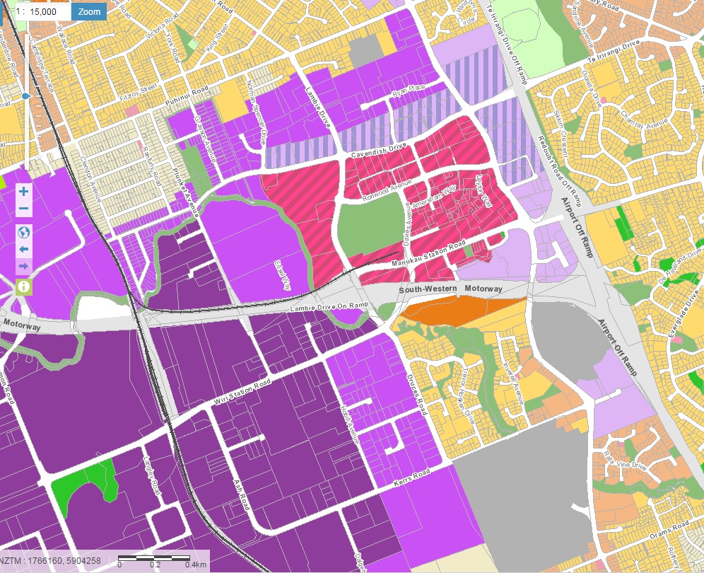
Metro Zone in dashed pink
Finally in relation to Transform Manukau:

Source: Panuku Development Auckland
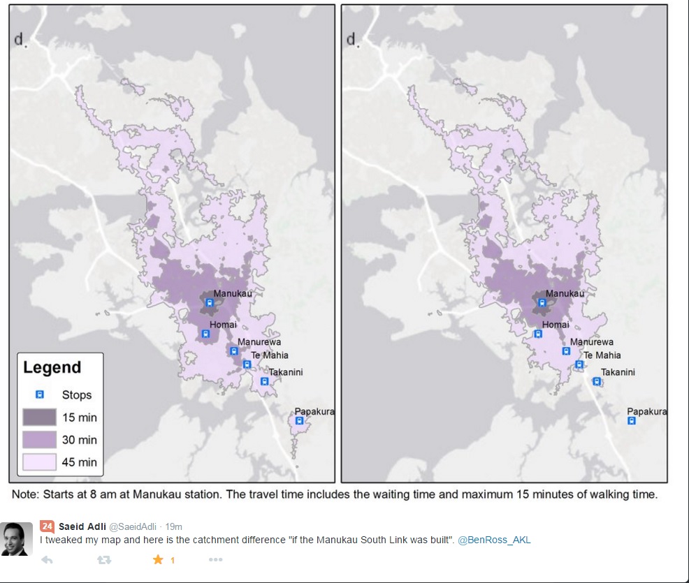
Manukau Rail and Bus Station would also pick up a Light Rail Station and become the Manukau Central Station for all three modes. The 800 metre catchment illustrates the reach of such a Central type station.
Closer in there are two ways the Southern Airport Line could traverse Manukau City Centre:
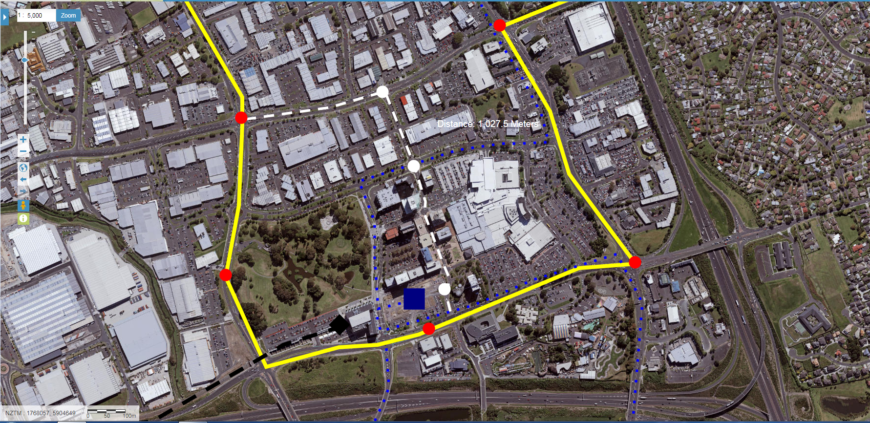
It depends if you want to serve speed or total accessibility. Technically given the location of the Manukau Central Station (the red dot, blue square and black diamond all huddled together representing heavy rail, light rail and a bus station all in one) and the 800 metre radius of such a station (see the Panuku picture further up) the yellow route would suffice enough for both speed and accessibility. There would still be stations on Lambie Drive to service the western flanks of the Metropolitan Centre Zone of Manukau City Centre while another station at the intersection of Manukau Station, Great South and Redoubt Roads captures Rainbows End, Lakewood Plaza and whatever redevelopments happen in the eastern mall car park.
The blue dots represent either the 33 Great South Road Bus or the 365 Manukau to Papakura via Manurewa and Takanini Stations bus that either link up southern Manukau to central Manukau or run right through the core of Manukau with frequencies of at least 20 or 15 minutes. The 33 Bus essentially links Manukau Central Station (and the Southern Airport Line) to the core and northern flanks of Manukau City Centre leaving the Southern Airport Line to run around the outside while still servicing significant areas of activity (the Lambie Drive area from Cavendish Drive to Manukau Station Road is zoned Metropolitan Centre with the land owners looking at apartments over the Manukau Supa Centre area).
None the less I have the white route for the Southern Airport Line if it is wished to bring the Line right through the middle of Manukau City Centre allowing the creation of transit malls down part of that route like seen on the Gold Coast.

Transit Orientated Developments creating Micro Centres
Like the Northern Airport Line, the Southern Airport Line offers a chance for Transit Orientated Development around each of the Lines’ stations. The beauty of the Southern Airport Line is that all of its stations along its 18km route are ripe for some good old fashion TODs! As a bonus most of the stations along the Southern Airport Line will also have cross-feeder busses running through them extending the accessibility of the Line and the viability of the TODs themselves:

Source: https://www.scribd.com/document/365399828/Southern-Airport-Line-LRT-Alignment-Proposals-and-Final#
As for the TODs themselves I usually work them to an 800 metre maximum radius with a 200 metre and 400 metre set of radii inside that 800m max radius.
800 metres is traditionally the walk up catchment of a station or stop thus the 800m catchment is where you would do high density developments to make most use of the that station and its catchment. However, if the station is traversing through a low or medium density area (like Te Irirangi Drive and Puhinui Station does) then making the entire 800 metre radius catchment dense development is going to give scale problems. Enter the 200 and 400 metre radii marks. 200 metres from the station is where you would do your most dense developments with the developments scaling down between the 200 and 400m mark and again from the 400-800m as the development transitions into the surrounding urban form.
For stations inside Manukau City Centre like the Manukau Central Station where the 800m radius mark is taken from the 200, 400 and 800m rules I would work a bit differently given stations inside Manukau City Centre will have overlapping 800m radii.
Your 400m and 800m radii still mark the transition of your urban form down as the Metropolitan Centre Zone phases into lower density zoning such as General Business, Mixed Use, Terraced Housing and Apartments or Light Industry just like you word normally with any TOD. The 200m radius where some of the most dense urban form might be found especially around Manukau Central Station is where I would focus niche, boutique and even artisan class types of urban form to both be an magnet to Manukau as well as give Manukau its sense of place unique to the City as a whole.
To further encourage this artisan type urban morphology around Manukau Central Station using the Gold Coast’s idea of transit malls and Panuku’s humanising of Manukau Station Road and Lambie Drive would certainly not go a miss.


And of course lets not forget the accessibility the Southern Airport Line (422 x 12 = 5,064 potentially crossing through plus what the busses and heavy rail bring into Auckland’s largest Metropolitan Centre) would bring as well (Redesigning the Transit Network #CitiesSkylines Style. Lessons for Auckland)
Link: https://twitter.com/SaeidAdli/status/658893255061323776
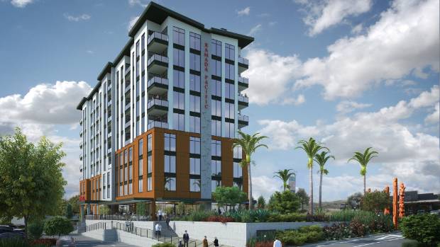
So let’s share the love a bit and also give Auckland’s largest Metropolitan Centre and core to our largest sub region some of that Light Rail love the Isthmus is getting. If you are not quite convinced here is a link to Manukau’s third larger hotel and apartments being built (after Lakewood Plaza and the Sebel): $25m Ramada Suites Manukau Pacific Centre to be built in south Auckland
Source: http://www.stuff.co.nz/business/100655869/25m-ramada-suites-manukau-pacific-centre-to-be-built-in-south-auckland

