
Our Forgotten Harbour shows its long history of neglect
Guest post from Stephen Lasham
Onehunga has a sticky problem, a problem that has been growing steadily over the last 100 years; a problem that has muddied the waters not just physically but also politically. The opening of Taumanu Reserve was the first move in the right direction in many decades, but it is not sufficient. Clearing the mud, completing the reclamation, and preventing further deposition would once again open the Manukau Harbour for recreation and transport.
The Report of the Waitangi Tribunal on the Manukau Claim (the WAI8 report), describes the Manukau Harbour as once having crystal clear water and white sandy beaches. It was a pristine environment, a natural food bowl and a treasure of Auckland.
Those who appeared before us described the state of the harbour from the 1920’s. They recalled how in numerous inlets and creeks finfish and shellfish abounded. They recalled catching large quantities of flounder with their feet and with spears, the large quantities of snapper and stingray and of collecting mussels and oysters without getting their feet wet. They recalled how the murky waters were once crystal clear and the thick mud once firm white sand. It was said that siltation was first noticed in the 1940s when a creeping black sand started moving across the harbour.
Sedimentation of harbours occurs as a natural process over thousands of years, but these processes are greatly accelerated by human activities such as erosion and changing water-flow patterns.
Such has been the case with the Manukau, especially around Onehunga where urbanisation has featured heavily over the last 100 years. Trees have been removed to make way for roads and houses, the foreshores have been indiscriminately reclaimed for industry and transport, and land run off has been accelerated by closing in streams and directing land drains and sewerage into our harbour.
Clearing trees was the initial catalyst; turning bush into farmland removed the natural defence against erosion, so that wind and rain could move large amounts of soil into the harbour. Urbanisation introduced roads, and with these came a need for land drains to quickly move water that could no longer permeate the surface. Urbanisation added sewerage, which is poorly managed and allows sewage to flow into the harbour during extreme weather. Then came the reclamations: around the Manukau for the Auckland Airport, the Manukau sewage treatment works, for rubbish tips, for industry and roads. Much of Onehunga’s foreshore, previously accessible to the public, was cut off. The people lost access to the water, and with it, lost sight of what was being done to it behind their backs; some simply stopped caring for what they could no longer use.

Source: Stephen Lasham
The reclamations for Industries and roads that lined the Manukau were a disaster, allowing pollution in many forms to enter the harbour relatively unchecked. In a 2010 report by the New Zealand Journal of Marine and Freshwater Research, the Mangere Inlet was thought to be the most polluted tidal water area in the Auckland region.
In 1950, the Orakei works served the area from the Whau Creek (Avondale) to Orakei in the east. There were 5 communal sewer outfalls into the Tamaki River, 5 into Manukau Harbour, and 20 industrial outfalls into Manukau Harbour up stream of the Mangere Bridge.
Until the Sewage Purification Works were built in 1962, all industries discharged their wastes into the inlet. Industries included three large meat works, an abattoir, three phosphate fertiliser works, two wool scours, fellmongeries, soap and candle works, a wood-pulp works, a battery works, a woollen mill, a tannery, and glue works. In addition, there were discharges from Middlemore Hospital and Otahuhu Borough Council’s septic tank. There were intermittent discharges of leachate from various refuse tips and run-off from the Otahuhu railway workshops and later from the steel recovery plant at Otahuhu.
The reclamations brought industry close to the water edge, making for easy disposal of waste, but underground something else was happening. Many of the reclamations were built from rubbish, dumped on the foreshore and bulldozed further and further out into the harbour to become the base of the reclamation. Pollution from the fill was able to permeate through the ground and leach into the harbour. Such was the case with land reclaimed at Pikes Point, as just one example.
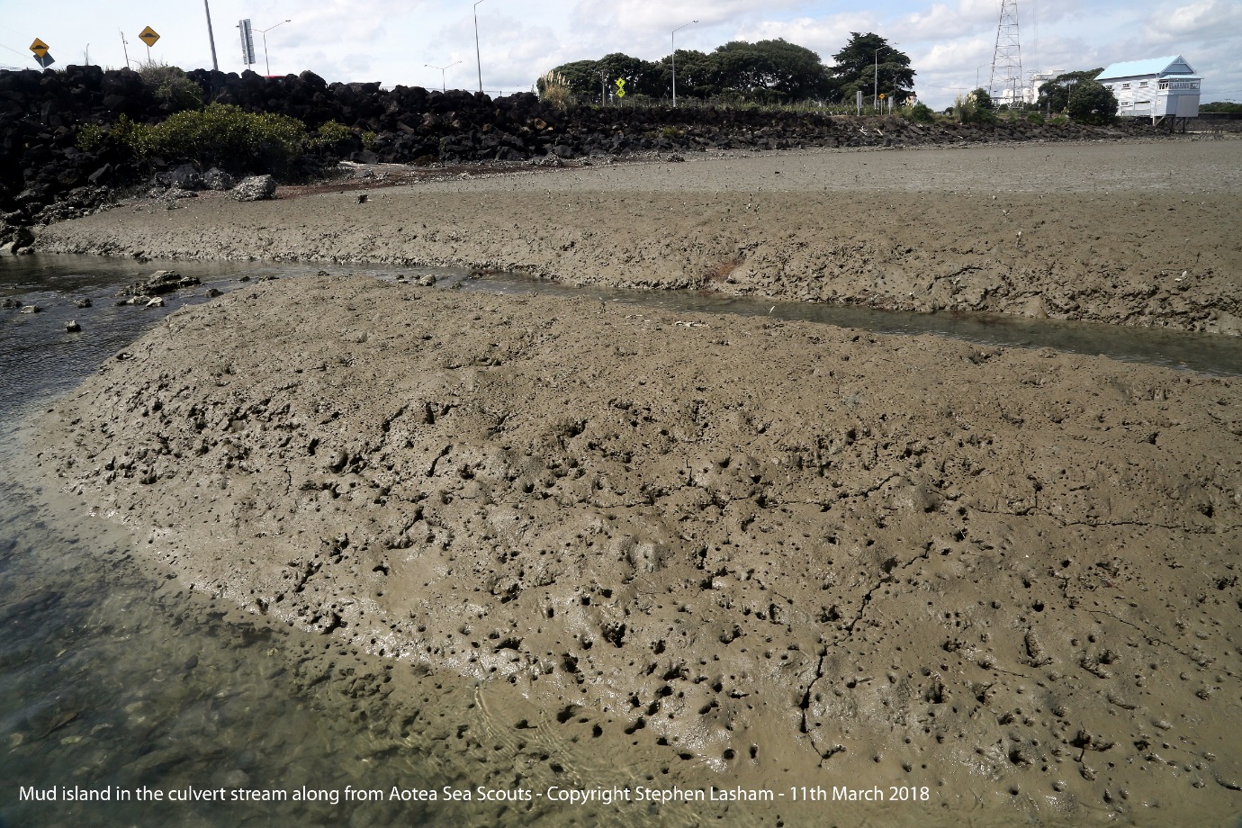
The reclamations changed the natural shape of the coastline, which in turn changed tidal flows, altering the way sedimentation processes occurred in the harbour. Where currents previously aided the flow of suspended material out to sea, these materials were suddenly allowed to drop out and deposit on the harbour floor. The previously white sandy seabed, as recalled in the WAI8 hearings, was slowly overtaken with mud. In the harbour around the Port of Onehunga and along to Taumanu Reserve, the mud has been measured up to 70cm deep. Between the Onehunga Yacht Club and the Aotea Sea Scouts a river outflow carves a path through the mud to reveal the seabed as it once had been.
Source: Stephen Lasham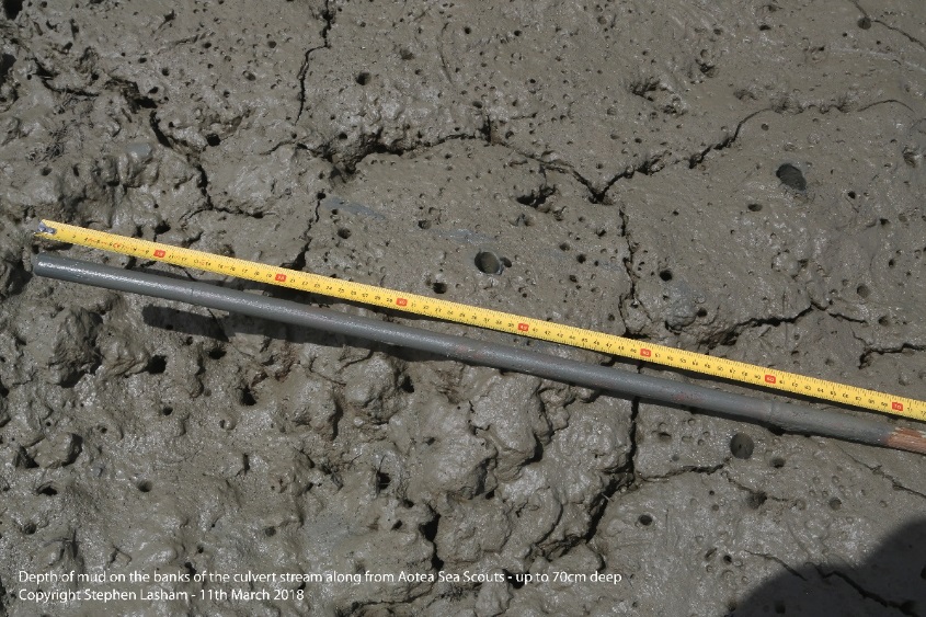
Source: Stephen Lasham
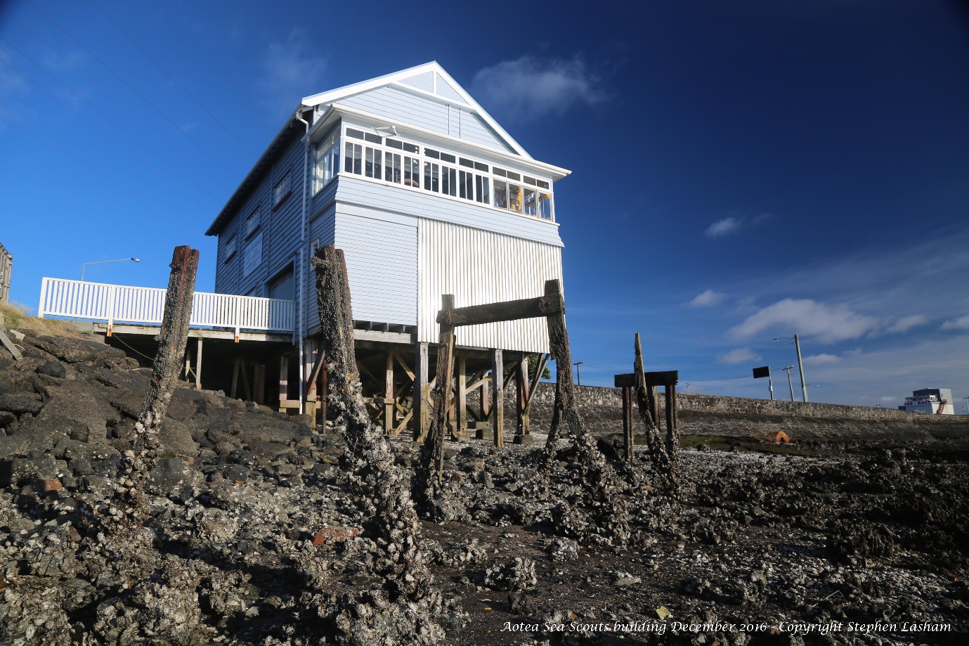
The coastline between the Port of Onehunga and Taumanu Reserve is fairly recent; it was created through reclamation of the coastline for the development of State Highway 20 and expansion of the Port of Onehunga. Gloucester Park, which sits just behind the Sea Scouts hall, was once part of Geddes Basin, a breached volcanic explosion crater that formed a natural sheltered harbour. This harbour was closed off and filled in by the Onehunga Borough Council in the 1930s, and was used as a rubbish tip for many years.
In June 1941 it was reported that five of the council’s rubbish trucks were employed all day to collect sufficient valueless rubbish to fill an acre of Gloucester Park.
New Zealand Herald, Volume LXXVIII, Issue 23992, 16 June 1941
Orpheus Drive and State Highway 20 were built in the 1960’s, cutting off a large stretch of the Onehunga coastline that ran along Beachcroft Avenue around to Onehunga Harbour Road, and in doing so, created the Onehunga Lagoon. Here we can see negative effects; streams and inlets that run into the lagoon are checked, causing a build-up of mud on the bed of the lagoon. Although Auckland Council have been approached in the past to dredge the lagoon, they have neglected to do so, and each year the lagoon becomes shallower.
The area beyond the lagoon is the area that I refer to as Onehunga’s Neglected Foreshore or ONF for short. Auckland Council have another definition for ONF, “Outstanding Natural Feature”. By this they are referring to Gloucester Park and the marine tuff that constitutes the seabed just off the coast by the Sea Scouts. Before the 1930’s this was an Outstanding Natural Feature, but since then the motorway has carved the area in two and reclamations have altered the area significantly. The beachfront itself is a disgrace, with highway rubble indiscriminately dumped onto it, rusty lumps of metal protruding from it, and a land drain causing rusty stains across the rocks. The rocks themselves are covered with razor sharp invasive Pacific oysters, making the area a hazard to walk on. Having designated the area as an Outstanding Natural Feature, Auckland Council have a responsibility to tidy the area up, but so far have failed to act. Perhaps it is because even they know in truth that there is little outstanding or natural here anymore.
The ONF designation was added to this area during the development of the Auckland Unitary Plan, and went unnoticed until it was too late to challenge. The impact of this designation is significant, as it stops sensible planning for restoration of this stretch of neglected coastline.
Taumanu reserve started the process of restoring the foreshore, and we await its completion between Taumanu Reserve and the Port of Onehunga. This final section of work is blocked by the ONF. The NZTA advised Aotea Sea Scouts during the East West Link consultation, that they did not include plans for restoration due to the ONF. MHRS, TOES and Aotea Sea Scouts have appealed to Auckland Council through the local board to remove the ONF designation, which Council have not done. The option to lodge a private plan change was suggested, but at $30,000+, this is prohibitively expensive.
There are those that will argue against further reclamation, and the answer to this is reflected in Taumanu Reserve. In contrast to the past bad reclamations, Taumanu was made with clean fill, it was carefully designed to prevent leaching, and its purpose was not for industry and roads but to restore part of the foreshore lost when State Highway 20 was built. This was part way to honouring commitments made back in the 1960’s to do just this.
Taumanu reserve provides recreational space for a growing Auckland, it brings people back to their waterfront, and provides new habitats for birds, with its naturalised water’s edge and planting of native trees and fauna. Taumanu is so unlike those historically bad reclamations it has now won six awards, including a community input award, recognising the importance of working in collaboration with the community. Restoring our access to the water catalyses our desire to see further improvements to the Manukau and the health of its waters restored. Such goals were described in the WAI8 report findings, and are long overdue.
Completing the restoration of the foreshore between Taumanu Reserve and the Port of Onehunga is a significant improvement to the coast. It enables active dredging of the mud that has built up, with this mud being used for mudcrete, locking up the contaminants and making excellent base material for the reclamation. With mud removed, the depth of water increases, and the seabed is restored; both factors for improving marine ecology, and increasing marine diversity.
Dredging the mud from the Port of Onehunga is a necessary step to opening the Port as a viable transport terminal, allowing the reintroduction of ferry operations between Waiuku, Glenbrook, Clarks Beach, Cornwallis and Onehunga, and complimenting the Port as a transport hub for light rail across to Mangere Bridge and into Onehunga. The Port as a transport hub brings people once more to the water’s edge, and onto the water, and further catalysis our desire to see even greater improvements to the Manukau. It is time we stopped our waterfront being Onehunga’s Neglected Foreshore and instead turned it into an Outstanding Naturalised Feature.
Additional pictures below.

Source: Stephen Lasham

Source: Stephen Lasham


