
Applying Urban Geography to Southern Auckland
As the Auckland Plan goes for its refresh the question still remains in where to house 200,000 new residents and around 50,000 new jobs in Southern Auckland (see: 200,000 New Residents. Where to House Them and Employment in South Auckland?). Before I go into the Urban Geography exercise with the South a couple of points on the Auckland Plan and its refresh.
First the problem:
Why refresh the Auckland Plan
9. The current Auckland Plan was adopted in 2012 and was an important and useful document for its time. Consistent with international best practice, there was a commitment to review
the plan after six years in recognition of the large number of ‘unknowns’ at that very early period in the life of the new council, including the rate at which Auckland would grow.
10. The plan set the growth model for Auckland. The Unitary Plan took its direction from this and enabled the model through its zoning.
11. In the interim, the plan has provided direction in some significant areas. For example, it built the strategic case and the momentum for the construction of the City Rail Link. Inclusion of
this in the plan was not simply about agreeing a project but about creating the framework for Auckland’s future transport strategy.
12. While these are significant achievements, the plan has shortcomings which have become evident through implementation and which means it cannot provide the support for decision-making
the legislation intends.
Table 1: Problem definition of the current plan
| Problem
|
Description |
| Out of date data
|
· Based on 2006 data
· Does not reflect strategic work carried out since the plan was adopted |
| Integration/Development
Strategy
|
· Development Strategy sits separately from other strategic directions |
| Complex structure
|
· Contains too many layers and components
· People find it hard to work with which affects implementation · Limited integration between different components |
| Mixed content
|
· Includes range of strategic and operational content
· Detailed content better addressed in other plans and processes |
| No prioritisation
|
· Does not prioritise across the large number of strategic directions in the plan |
| Hard copy document | · Unable to update document to reflect significant changes |
| Targets
|
· Too many targets and many unmeasurable
· Unclear ownership of targets · Difficult to track progress as a result |
The recommended update approach:
- Option 4: Streamlined spatial (Recommended) (Attachment C: Recommended Option
description)- Updates and adds new general facts and figures
- Uses small number of organizing and inter-linked themes around Auckland’s key
challenges - Sets high level objectives (spatial and non-spatial) in these theme areas with brief
narrative - Focuses on Development Strategy to reflect Unitary Plan decisions; Infrastructure
Strategy; strategic work on urban, rural and future urban development areas; National
Policy Statement on Urban Development Capacity requirements; creates new growth
model - Excludes any further non-spatial initiatives, narrative or detail and removes more
detailed operational directives - Creates limited number of high level indicators to track progress and measures to
guide the work programme - Removes all other material in existing plan
- Creates digital plan
Full details can be read in the Addendum Agenda:
Spatial Development Ideas for Southern Auckland – An Urban Geography Exercise
I had illustrated to the Auckland Council Committee on Tuesday Auckland is developing like a donut with higher density residential development on the fringe and the majority of employment growth in the City Centre (and some out at the airport). The major problem that presents itself it we can not bring much more commuters by road or train through the Otahuhu-Mt Wellington Bottleneck to get to and from work without serious consequences to the environment and economy.

The presentation slides can be seen below while the video of me presenting can be seen here: The Auckland Donut: A Presentation to the Council Planning Committee

Establishing Southern Auckland into the Future
Bearing in what I have said above and previously I decided to repeat the spatial exercise I did with West Sydney in printing out some maps and placing down urban development ingredients (New West Sydney Aerotropolis Gives Rare Opportunity to Design New City).
This is what I came up with (and was presented with a pleasant surprise along the way):

That was the overview shot with Unitary Plan maps alongside to act as a guide.
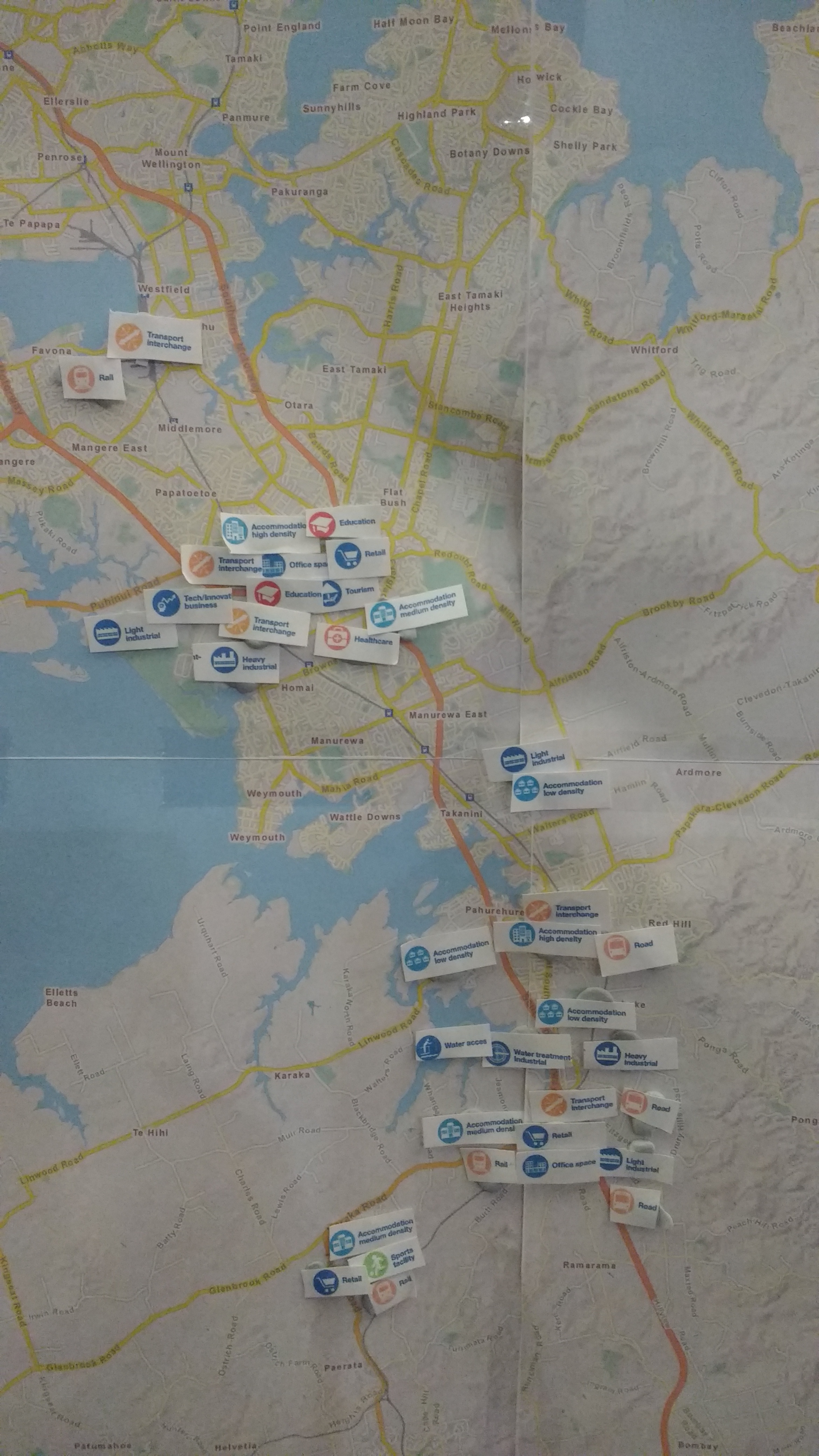
Here I go placing down the basic urban development ingredients between Otahuhu and Paerata. Elements included:
- Heavy rail from Otahuhu Transport Interchange to the Airport
- Bus way from Manukau Interchange to a new Puhinui Transport Interchange and then the Airport via SH20B
- Light Industry at the Puhinui Gateway area (below SH20B)
- Transform Manukau area represented by its mix of urban ingredients
- Light Industry and low density residential in Takanini owing to flooding from storm water issues
- Papakura cluster centred around Papakura Train Station and high density residential development with 800 metres of the station
- New fully fledged bus and rail transport interchange at Drury. This new transport interchange supports:
- Existing and new heavy/light industry in Drury
- New medium density residential development in the west and low density residential development in the east (flooding issues)
- New town or even Metropolitan Centre supporting retail and office space. Possibly even a new medium-sized mall (size of Pakuranga Plaza) given Manukau is the most southern of the malls currently (and would not be affected by this new mall owing to different geographies)
- New road from Ramarama Interchange to Papakura south (this is part of the Mill Road south corridor project by Auckland Transport)
- New rail station at Paerata and possibly Drury west
- New sports facility tied to Wesley College at Paerata
I could place more stuff but I need a larger map for that and for now I am just putting down the “essentials.”
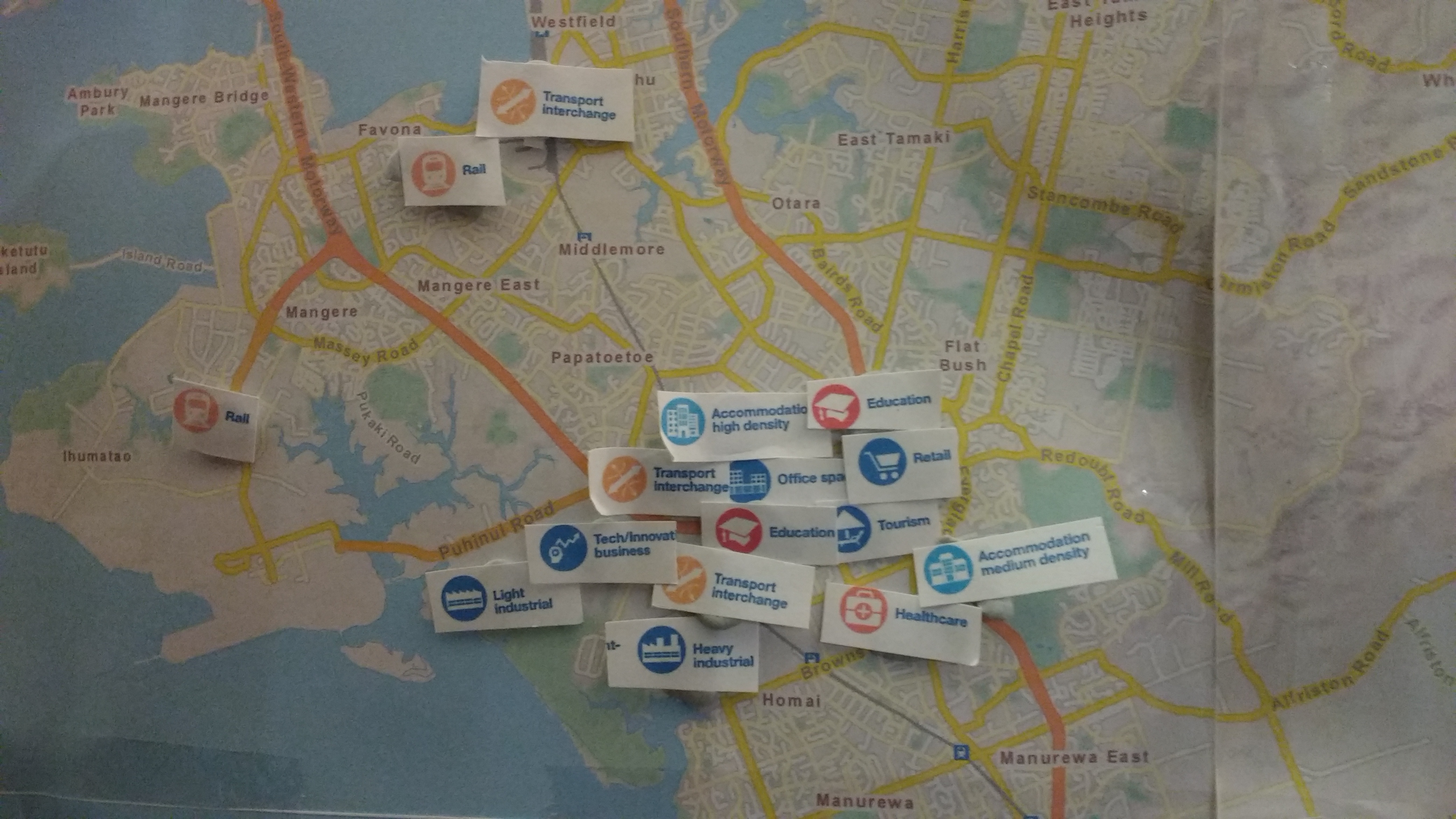
The close up of the Otahuhu to Manukau spatial area with the Manukau cluster, new Puhinui industrial complex and my desired heavy rail link from Otahuhu to the Airport illustrated (also see below).

The Botany Line Light Rail Transit follows the same route as the busway from Manukau to the Airport via Puhinui Station. One thing about heavy rail from Otahuhu to the Airport via Mangere is that Councillor Collins 324 bus issues (bus is often 30 minutes late) through Mangere would disappear as he could catch a train to Britomart from the new Mangere Transport Interchange Station avoiding industrial road traffic in the Otahuhu area.
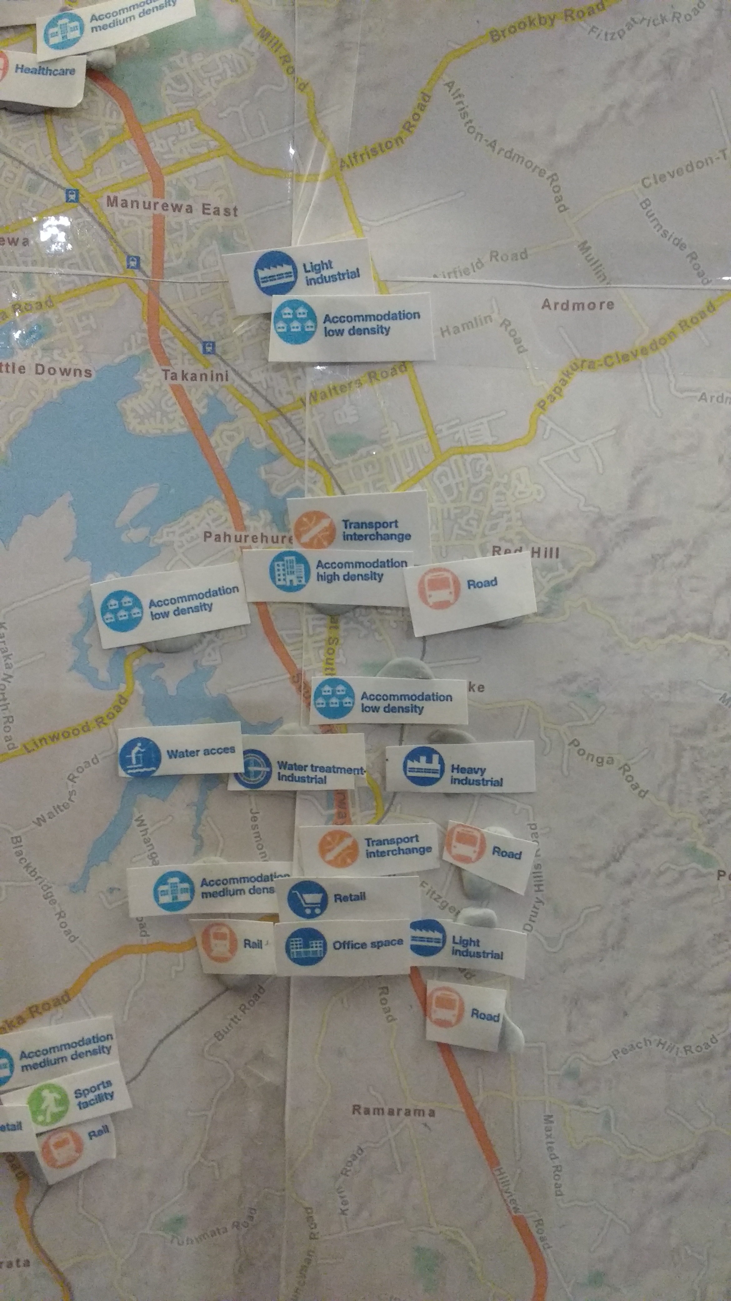
The close up on the centre of where most of the new Greenfield urban development would happen in Southern Auckland – between Papakura and Drury. I asked the question last night could a new Metropolitan Centre be established south of the Papakura Metropolitan Centre. The answer was mainly yes especially if a medium-sized mall was development along with a Centre within 800 metres of a new transport interchange at Drury. That is why you can see retail and office space flags around the Drury area but only retail at Paerata (it has Mixed Housing Urban, and Local Centre zoning). Medium density residential would take advantage of a new transport interchange and Centre at Drury. Meanwhile I have placed light industry to the east mainly due to the heavy industrial complex further north as well as flooding issues. One thing about establishing light industry to the east is that it can set aside land for a new multi-modal in-land port connecting to the rail line and the Mill Road South corridor much like the Wiri facility that connects to the rail line and Wiri Station Road.
Would Manukau and Papakura be affected by a new Centre and possible mall in Drury? No.
Manukau is a (minor) City Centre that has the agglomeration bonus affects the other Centres further south would not enjoy. Meaning Manukau services as an urban Core for Southern Auckland while Papakura and Drury serve their local catchments. Drury services itself and all the way west and south to Pukekohe while Papakura services itself, Karaka, Takanini and the lower areas of Manurewa.

Finally we work out way south to Paerata which is home of Auckland’s largest Special Housing area at some 385 hectares with a yield of 4,500 homes, a new Local Centre and a rail station. The land inside the SHA area is zoned Mixed Housing Urban which can allow medium density if three storey walk-up apartments are built. Hopefully they are within 800 metres of the proposed station as well as inside the proposed Local Centre. With Wesley College in the area I added a new Sports Facility to cater for demand from new and existing residents in the area. Also I have added a new Wastewater Treatment Plan west of Drury (it is proposed by Watercare) to cater for the sewerage as the South continues to develop. The new wastewater plant would also relieve the Southern Interceptor so that not all the sewerage needs to go to the main Mangere plant.
What do you think? Do I have the right mix and would it work in keeping more Southern Auckland residents closer to home while working? Or am I missing something here as we try to cater for 200,000 new residents and at minimum 50,000 new commercial and industrial jobs.
And don’t worry I have not forgotten about open spaces for informal and formal recreation.

