
Northern Airport Line debate prompts interesting question
Greater Auckland posted up on the different routes the Northern Airport Line (City Centre to the Airport) and the consequences of the different routes.
From Greater Auckland:
With the government supporting light rail, hopefully the team/s tasked with the project have now been able to move on from justification to delivery. While the high-level decision has been made, there’s still a lot of detail that needs to be worked out. One area we think needs a bit more debate is the route through the southern isthmus between Dominion Rd and Onehunga.
The current plan is to send light rail from the city down Dominion Rd to State Highway 20. It would then travel alongside SH20 to Onehunga where it would turn along Princes St to connect to the Train Station before continuing on to the airport. There would only be one station, at Hillsborough Rd, between Dominion Rd and Onehunga. From what I can tell there are a few reasons for that:
- In the trade-off between speed and catchment, speed appears to have been the only determining factor here.
- Motorways don’t make great public transport corridors. That’s because motorways tend not to be too welcoming towards people (noise, pollution etc). They also make accessing stations difficult for much of the catchment whilst simultaneously suppressing nearby development potential. After all, how many people choose to live next to a motorway. Motorways corridors are normally only used because they’re easier to deliver.
- There simply aren’t that many potential sites along that stretch of the route for a station.
This is highlighted in this map showing potential catchments of light rail below with a big gap in the middle around Hillsborough.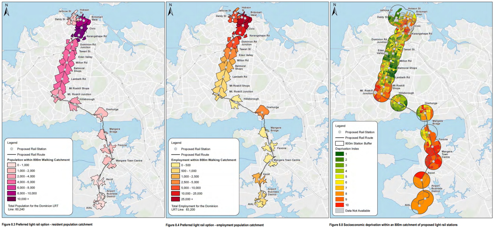
We think an alternative could be to instead send the tracks along Mt Albert Rd, Mt Smart Rd and then down Onehunga Mall. This is shown below in blue, compared to the current planned route in red.

…..
Source: https://www.greaterauckland.org.nz/2017/11/21/move-light-rail-serve-people/
Just a quick note that the Northern Airport Line will be running down SH20 and SH20A both motorways from Mangere Bridge to the Airport unless the line goes down Kirkbride and McKenzie Roads and then swings onto SH20A.
In any case the Greater Auckland post had me thinking two things:
- What is the purpose of the Northern Airport Line
- How would you build the Northern Airport Line
What is the Purpose of the Northern Airport Line?
If we are to answer Greater Auckland’s deviation of the Northern Airport Line then the question of the Northern Airport Line’s purpose needs to be answered first.
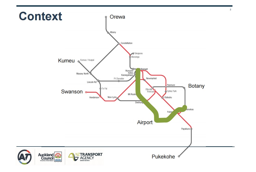
Is the purpose of the Northern Airport Line to “express run” from the City Centre to the Airport or is its purpose to maximise catchment to an area that does not have a decent transit network (I am thinking of heavy rail and the Northern Busway). Greater Auckland technically answers the question: maximising catchment of the line. Remember the Northern Airport Line is designed to offer a quality transit line for the Isthmus to either get to the City Centre or to the Airport through that maximisation of the its catchment. The Northern Airport Line was not and should not be considered for “express running” to the Airport from the City Centre. The Southern Airport Line via the Southern or Eastern (heavy rail) Lines and a transfer at Puhinui was designed for that express running to the Airport from the City Centre.


As noted above these are the travel times on the Southern and Eastern Lines to Puhinui pre and post City Rail Link. Add five minutes for your transfer at Puhinui and then another 10 minutes down the Southern Airport Line to the Airport and that will be your rough travel time. Around 45 to 50 minutes from Aotea and slightly less from Britomart. The Northern Airport Line is if the Royal Oak option goes in around 50 minutes (with plenty more stops long the way).
Cities Skylines also gives you a clue as well in the question of express running or maximising catchment:
Trans City vs Local District Transit. #CitiesSkylines Lessons for Auckland
In my ALL ABOARD. Light Rail Moving You Around. Lessons for Auckland post I had mentioned the two types of tram systems I run:
Four new tram lines were built with two connecting to the wider city and two travelling within the area forming a City Link type circuit. The photos below are of City Boulevard Lines 1 and two that run as a loop down the new Boulevard and through Forrest Road (one of the two east-west parallel roads). The other two lines that were later built are:
City Centre to Airport LRT Line. Think of it as Solaria’s City Centre to Airport via Dominion Road, Auckland equivalent with the Airport-Solarian Line (a metro/subway line) as the express Southern Airport Line).
Thorton Hills Interchange – City Boulevard Line. This links up the new urban area to a major interchange that serves busses and an inter-city train station
quote context: http://pllqt.it/533U97
So if the Northern Airport Line is to be built with maximising catchment in mind while the Southern Airport Line is set for express running to the Airport how would you build the Northern Airport Line?
How would you build the Northern Airport Line
Conventional wisdom is that you start building the Northern Airport Line from Queen Street in the City Centre down to Dominion Road as stage one then continue onto the Airport as stage two. All in all stage two should be done within a decade. The Southern Airport Line is for now a Bus Rapid Transit Line from Puhinui to the Airport via State Highway 20B with that being all done by 2021 and the extensions to Manukau and Botany done soon after (according to Auckland Transport tender documents).
To me this is half arsed and I think we can do a bit better here.
Again Cities Skylines offers a partial clue:
Lessons for Auckland?
The Northern Airport Line will be Light Rail while I am pushing the Manukau to Airport section of the Southern Airport Line to be Light Rail (Manukau to Botany will be bus).
The first is about capacity to meet demand (The Southern Airport Line intersects Manukau Bus Station and Puhihui Train Station that have heavily patronised transit lines running through them) and the second is about ambience especially in a major Metropolitan Centre like Manukau.
Manukau or rather Transform Manukau is 600 hectares in size compared to the main City Centre being around 385ha (this does NOT include Port of Auckland but does include Wynyard Quarter). Manukau is also in the middle of a large regeneration program that includes intensification and upgrades of public spaces. Manukau is also forecast to house 20,000 new residents (I say it can hold double) over the next decade or so.
Simply put given its large size busses are not going to quite cut it moving people around Manukau nor to and from it to another major employment area like the Airport. Ambience is also in play and like the City Centre having a high amount busses inside Manukau doesn’t exactly work either.
Running higher capacity trams along the Northern Airport Line through the Airport and down to Manukau via the Southern Airport Line would be Auckland’s example of my Airport to City Centre LRT via William Boulevard Line coupled with the Airport to Laytonville Metro Line.
A LRT Line doing a circuit of Manukau and Manukau City Centre linking up the main commercial area, main residential area to the south, the events centre to the south-east and AUT to the north-east would be an example of my City Boulevard Lines.

Source: Auckland Transport
Remember via budget control you can use smaller trams (that can be coupled up to make larger units as I can in Cities Skylines (75, 150, 210 (same as the single unit E-class)) to start with and up the capacity as the demand allows.
I believe in the dig once, get it right policy that New Zealand struggles with (due to our often lack of foresight). While building LRT instead of a busway for the Southern Airport Line between Manukau and the Airport is more expensive those costs are paid off pretty quickly from the demand and ambience side.
quote context: http://pllqt.it/m083lm
So this is how I would build both Airport Lines:
- A through-station at the Airport where the Southern and Northern Airport Lines meet
- At the same time the Light Rail tracks are extended in both directions:
- To Manukau Bus and Rail Station via Puhinui Station for the Southern Airport Line
- To Onehunga Station for the Northern Airport Line
- Depot built alongside SH20B that is zoned Light Industry
- Once the Northern Airport Line is at Onehunga the tracks continue then to Dominon Road via Royal Oak
- Finally the Northern Airport Line tracks run up Dominion Road to the City Centre
- Northern Airport Line trains would run to the Airport and continue to Manukau on the Southern Airport Line before backtracking the trip in reverse
- The Airport Station would be a 4-track station to allow both Northern-Southern Airport Line running and dedicated express Southern Airport Line only running
While the Northern Airport Line is being built from Onehunga to the City Centre you have the option of either catching the train to Onehunga and transferring onto the Northern Airport Line to complete your trip to the Airport or use the Southern Airport Line.
Reference
The Northern Airport Line to Onehunga first concept is courtesy of Nicholas Lee. The Southern-Northern Airport Line through-running concept is courtesy of Bryce Pearce. I give full credit to both gentlemen for these concepts.
Source: Auckland Transport and NZTA
Northern-Southern Airport Line through-running
The above concept was brought up by Bryce Pearce. The idea is that the trains on the Northern Airport Line would continue through to Manukau via the Southern Airport Line and vice versa on the way back. This means no termination at the Airport Station and no cumbersome transfer for those in South Auckland who work in the Airport Industrial Complex along SH20A.
The through-running concept is a stroke of brilliance as it widens the catchment of the Southern Airport Line.

Source: Auckland Transport
Most Airport and industrial complex workers come in from South Auckland. Allowing the Northern and Southern Airport Lines through running rather than terminating at the Airport means a South Auckland worker could get to the complex the following way:
- Train to Puhinui Station or bus to Manukau Station
- Transfer to the Southern Airport Line at either station
- Take Southern Airport Line which then carries onto the Northern Airport Line
- Get off at industrial complex station
Basically only one transfer not two.
What is the purpose of the Northern Airport Line and how do you plan to build it. Answer those two question and everything else including the Southern Airport Line falls into place.

Source: The Spinoff

