
The answer is yes
Then following series of Tweets below got me thing about a serious question with our planning regime currently in Auckland:
The Auckland Transport Frequent Transit Network 2016 was arguably an exercise in just planning transit lines with little regard to destination and origin planning (i.e where do trips start from and where are they going or wanting to go).
Greater Auckland’s Congestion Free Network 2.0 goes one better and develops a proposed Network of Light Rail, Heavy Rail and Bus Lines that go across urban Auckland.
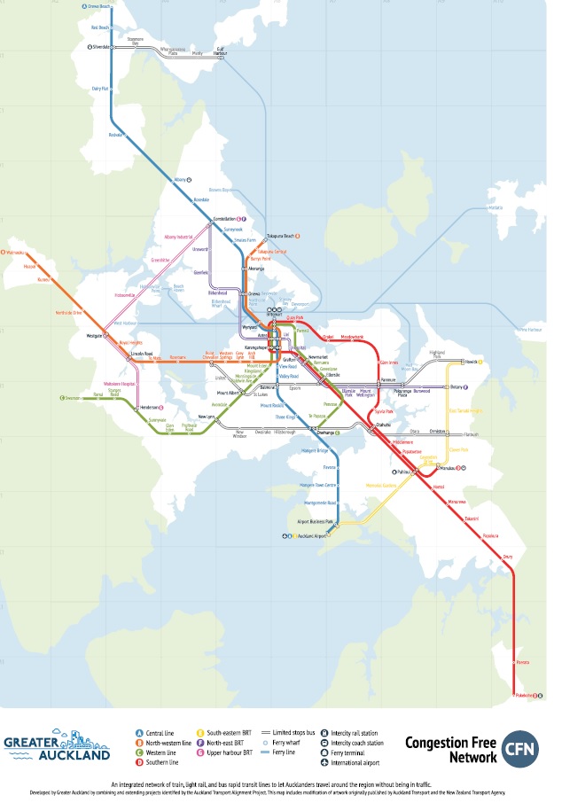
Source: Greater Auckland
However, when I look at Keesmaat’s Tweet stating that: “This is the outcome when a region focuses on *only* building transit + not building mixed use dense places that make that transit a regional network + a real transportation choice. Hubs + density needed in our suburbs; RTP reinforces downtown as the only regional destination” I wonder if the CFN 2.0 coupled with the Auckland Plan Refresh fails the Keesmaat Tweet Test.
The answer to that question is yes the CFN 2.0 and the Auckland Refresh does fail the Keesmaat Tweet question when the two are combined.
This is not an indictment against Greater Auckland (more of a critical critique) but it is against the Auckland Plan Refresh team (who struggled to marry up the CFN 2.0 to the Auckland Transport Alignment Program (which ironically the new Transport Minister was able to and is doing via an ATAP refresh) and the wider goals of the Auckland Plan). The Auckland Plan Refresh is treating Auckland as the City Centre being the only regional destination. That is wrong as Auckland has two regional destinations: The City Centre and Manukau including the Wiri and Airport industrial complexes.
The CFN 2.0 still has the bulk of its main transit routes radiating from the City Centre as Auckland Transport tends to do with its transit layout. But to be fair to Greater Auckland there is four Cross Town routes (one in the south, two on the Isthmus and one linking the west to the north) although in critical critique of those four cross town lines only two are Bus Raid Transit and two are just limited bus stop with no line names. Ironically it is the two Central to Botany/Howick cross town lines that will be quite busy in the off-peak and weekends. Furthermore I would add another cross-town line from Te Atatu to Avondale via Rosebank Road through to Greenlane via Green Lane West and the Showgrounds before heading across to Glen Innes Station via the netball courts nearby. One other critique is that the South Eastern BRT (or Southern Airport Line as I call it) should be Light Rail from the Airport to Manukau with busses continuing the trip out to Howick. Tje reasons for this are explained here: Northern Airport Line Verses Southern Airport Line and All the Options in Between. What Are We Wanting to Achieve?
Back to regional destinations
Auckland has two regional destinations and a few sub-regional destinations (most of them the Metropolitan Centres). We are blessed that already six of the ten Metropolitan Centres sit on the heavy rail network with Albany Metropolitan Centre near the Northern Busway. The rest of the Metropolitan Centres are to be connected up with Bus Rapid Transit or Light Rail (Takapuna). The problem is we are not making best use of these Metropolitan Centres including the ones under active regeneration programs such as Takapuna, Henderson and Manukau. Our Council and others are still set to this single regional destination mind set and that simply put won’t cut the mustard anymore – not under the new Government regime.
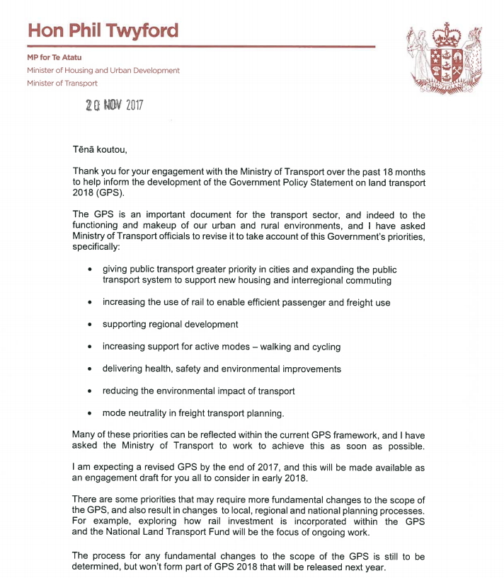
Source: https://www.greaterauckland.org.nz/wp-content/uploads/2017/11/Phil-Twyford-2018-21-GPS-change-page-1-1.jpg
That was Minister Twyford’s letter to the Ministry of Transport about his expectations with the Government Policy Statement 2018-2021 on transport. The first bullet point stating: “giving public transport higher priority in cities and to support the public transport system to support new housing and inter regional commuting” has my interest the most.
We know the first stage of Regional Rapid Rail (Hamilton to Auckland) is to get under way next year and we also know the Southern Airport Line (Manukau to the Airport (where the Southern, Eastern commuter and inter city trains intersect with the SAL)) is due to start construction next year with completion by 2021 (and 2023 to Botany)(Note: as I wrote this I was presented an Airport Access Case PDF which gave priority for full Rapid Transit from Botany to the Airport at a cost of $1.6b. More on this next week).
We also know Panuku has set Manukau up for it to draw maximum utilisation of its regional and inter-regional connectivity strengths:


The Minister is also looking at large-scale urban development from Manukau down to Pukekohe with more in the northern Waikato. This would be consistent with my Guest Lecture: Inter-Regional Planning and Sustainability post but inconsistent with the Auckland Plan Refresh (or rather the Auckland Plan refresh is inconsistent with Panuku, the Minister and my Guest Lecture):

Source: Auckland Council
The “quality compact approach” is wishy-washy and does not reflect the individual characters of larger areas like our larger Metropolitan Centres. The “quality compact approach” also does not meet the circumstances that Manukau, Albany (both touted as Super Metropolitan Centres) and Westgate have and provide (due to their large catchments).
These nodes as it were need to be treated in their own sub group rather than being lumped with the wishy-washy “quality compact approach” which does not say much at all if anything (given the Rural Urban Boundary is already in place via the Unitary Plan).
So if we look at what the Auckland Plan Refresh has it is treating Auckland having two major regional nodes (Manukau and the City Centre) and two smaller but still very important nodes (Albany and Westgate) then is it a case of our urban planning and transit planning not effectively set up for these nodes. Again the answer is no as most of the key transit lines still radiate out from the City Centre giving the implication that we are still focused on Downtown being the only regional destination when I see effectively four (two major and two smaller).
We also have to remember that while the City Centre contributes to 20% of Auckland’s GDP (7.4% of national GDP so does Manukau:

Source: HLPP – Panuku
If both areas are producing the same amount of GDP output (one being commercial the other being commercial and industry (industry that is critical to Auckland (logistics and manufacturing), both are major growth areas, both have large catchments and both are regional and inter-regional then they should be treated on equal par in urban and transit planning exercises.
In concluding remarks what Keesmaat said about transit maps verse transit networks (sole regional destination vs multiple regional destinations) applies to Auckland. While the Congestion Free Network makes an excellent start our planning is still focused on the former rather than the latter: This is the outcome when a region focuses on *only* building transit + not building mixed use dense places that make that transit a regional network + a real transportation choice. Hubs + density needed in our suburbs; RTP reinforces downtown as the only regional destination”
We have two major regional nodes or rather Centres and two smaller but important nodes all with large catchments. Our spatial and transit planning should be built to factor this in (and if so then build on the foundation that the CFN 2.0 does give us).

Source: http://theplan.theaucklandplan.govt.nz/wp-content/uploads/2012/05/Map-B.1-Inter-Regional-Connectivity_120427_noTitle1.jpg

