Resilience is the name of the game for Auckland’s fastest and largest growing sub region
In pondering that the City Centre to Mangere Light Rail Line (CC2M) could start at the Airport end not the City Centre while also connecting into the Airport to Botany Rapid Transit Line (A2B) some thoughts on how we could use this to improve Southern Auckland’s transit network further came up. (See: NZTA Have NOT Ruled Out Starting City Centre to Mangere Light Rail from Airport End First, Queen Street End won’t start until AFTER 2021)
Background
Southern Auckland is relatively blessed with the New Bus Network and Eastern Bus Network coupled with the heavy rail network and the processes starting for both the Eastern Busway and Airport to Botany (see: Airport to Botany Rapid Transit (A2B) Including Manukau Route Selection Open For Consultation). We have the 31 Botany to Mangere via Otara, Hunters Corner and Papatoetoe Station), 32 (Mangere to Sylvia Park via Otahuhu Station and Otahuhu Town Centre, 33 (Great South Road from Otahuhu to Papakura), 35 (Botany to Manukau via Flatbush) and the 380 Airporter Frequent Service Busses running every 10-15 minutes seven days a week forming a bus spine while the heavy rail network forms at the moment the rapid transit spine. The South and East also have a decent amount of feeder busses and back up routes like the 325 and 365 although lack of decent frequencies and bus lanes hinder them in being optimal.
As mentioned earlier we have Airport to Botany on its way with Stage 1 from the Airport to Manukau via Puhnui Station completed by 2021 and the 38 that will serve it running every 10 minutes (the 36 will replace the 380 between Mangere and Manukau).
The Eastern Busway has started construction and will be completed with the completion of the Botany Interchange by 2026 (a good target time to get Light Rail to Botany from the Airport).
Pukekohe Electrification along with the new stations at Drury and Paerata are set down for construction post 2021 and completion by 2025 with a bit of luck
Finally the City Rail Link in the City Centre once operation 2024 will allow trains to run every 10 minutes all day every day when Auckland Transport finally pulls finger to do so.
Population growth in the South
Per the Auckland Transport Alignment Project Southern Auckland currently stands as the largest population by sub-region and also the fastest growing sub region as well.

ATAP Southern 
ATAP Manukau 
ATAP Central
To make the situation even more unique most growth is going to be away from the City Centre while Auckland Transport gets antsy in trying to bring residents south of Manukau and the Airport north of those two points for work due to constraints at Otahuhu and Mt Wellington.
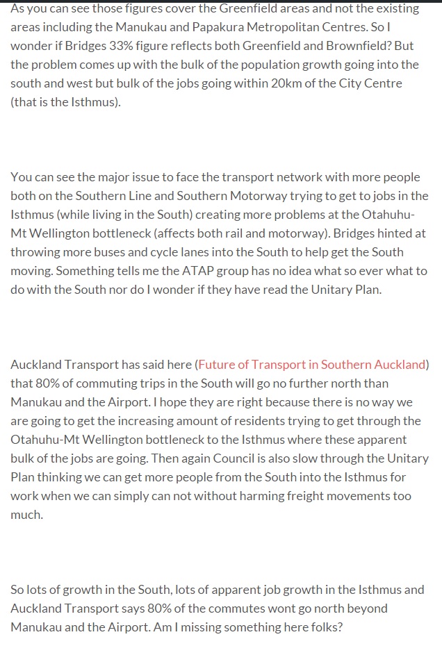
ATAP south problems 
ATAP pop vs jobs Source: Auckland Transport Alignment Project
Simply put the Southern Line is not exactly going to cope without resilience building south of Manukau while getting CC2M and A2B start from the Airport ASAP will give better resilience north and east of Manukau.
Enhancing Southern Auckland’s Rapid Transit Network
Earlier this year Auckland Transport and the New Zealand Transport Association did some public consultations of how the future of the South’s transit network should be shaped. Me being an Urban Geographer of course went researching and filed the trusty Official Information Act request.
The results that came back were very interesting and surprising:
Southern Auckland to Get Light Rail?
Written by Ben Ross – Talking Auckland
Could Drury to Manukau/Puhinui get Light Rail in the Future?
When one asks questions one will usually find the answers. When one asks specific questions to help with their submission on transport investment for Southern Auckland you get a rather pleasant surprise:
6. What issues and opportunities do you see in providing a new Rapid Transport Network (RTN – e.g. buses or light rail) between Drury and either Manukau or Puhinui?
That was Question Six to the Supporting Growth Alliance – South submission page (Feedback form for transport options(external link) )in relation to future transit south of Manukau. The question ties in with this exchange between myself and the Alliance:
“In regards to the bus lanes on State Highway 1
What is the methodology for providing bus lanes down State Highway 1 from Drury to Manukau when:
- No Auckland Transport commuter service would use this as AT works on the priority of feeding into rail stations and the 33 Great South Road service
- No AT commuter service would use SH1 in the future given the above
It seems it would duplicating and waste resource for little gain when a Rapid Transit Network already exists (the Southern (rail) Line), a Frequent Service Network already exists (the 33 which can be extended to Drury) and future RTN (running a service down the upgraded Mill Road is prudent to build resilience if the 33 bus and Southern Line are impaired).”
The vast majority of people who live in the south need to travel north for work and at present, less than 10% of people in the south currently use public transport to get to work. We are considering upgrades to the rail network in the south to enable rail to play a much greater role in meeting the current and future travel needs of the south.
However, given the scale of growth anticipated in the south over the next 30 years, relying solely on the rail network may not be enough to support growth in the long term. We are therefore considering additional options for the Rapid Transit Network (RTN) to continue to provide access and mode choice from the South in the long term.

That is the first time I have ever seen Public Authorities mention that Southern Auckland growth is not only higher than they ever anticipated (I have long written on this) but the Southern Line even with FOUR Mains backed up by the Great South Road 33 Bus will not be enough (a surprise to me).
While I have mentioned in the past the Mill Road corridor should have busses running along it connecting Papakura to Manukau to give us resilience it was not anticipated it would be for because the Southern Line could not cope.
Source: Southern Auckland to get Light Rail?
Overall Concept
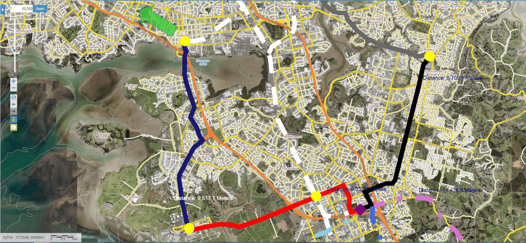
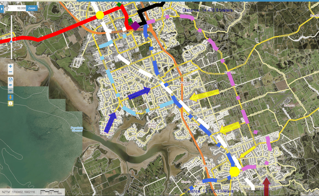
Starting in the central to northern flanks of Southern Auckland we see the following:
- City Centre to Mangere Line in navy blue (with it continuing to the City Centre)
- Airport to Botany Stage 1 in Red
- Southern and Eastern Lines in White
- Eastern Busway in Grey
- Airport to Botany Stage 2 in black
Apart from the Eastern and Southern Lines which are already built the rest are confirmed one way or the other. Assuming that indeed NZTA does start City Centre to Mangere and Airport to Botany from the airport end first to their respective destinations then we have the basics of a cross town network plugging in gaps not served by the rail system. Of course the Eastern Busway has recently started construction and will be complete 2026. So with all this there are no further additions needed to the Rapid Transit Network here (apart from extending A2B to Howick via Botany Road).

Going to the southern urban flanks of Southern Auckland this is where the most opportunity can present it south to an area facing rapid residential population and industrial growth. Between Manukau and Papakura only the Southern rail Line services are deemed Rapid Transit while the only Frequent Service Network (at least every 15 minutes) bus is the 33 Great South Road service and that runs parallel to the rail line for its journey (except Homai). However, the southern urban area has excellent and numerous feeder services that can be stepped up when the rapid transit network is bolstered in this area.
Three new Rapid Transit Network spines would supplement the Southern Line giving better accessibility and resilience for the South heading to the big employment complexes further north.

Finally we have the rural areas of Southern Auckland where the largest amount of Greenfield Sprawl will occur in Auckland (55,000 homes for 165,000 residents, and 35,000 jobs). With Drury South and Paerata under way we have the Southern Line again forming the only Rapid Transit spine in the area. However, unlike further north I do not see the need to expand the RTN south of Drury as feeders into Drury South, Paerata and Papakura would be more than adequate in handling the growth (providing we bolster the networks further north).
We also have Mill Road south linking Papakura and Drury South to the Southern Motorway at Rarmarama giving further resilience there.
Now lets take a look close in in strengthening the South’s transit network.
Mangere-Otahuhu-Otara-Flatbush

Otahuhu to Manukau including Botany and Mangere
As noted earlier Southern Auckland is blessed with a solid bus network and the two rail lines. This makes enhancing the Rapid Transit Network a straight forward exercise at little relative CAPEX (capital expenditure expense) outside of the two Airport Lines. In fact City Centre to Mangere and Airport to Botany are the two major Rapid Transit investments that form a cross town spine through Southern Auckland.
As stated yesterday in my NZTA Have NOT Ruled Out Starting City Centre to Mangere Light Rail from Airport End First, Queen Street End won’t start until AFTER 2021 post there is the strong possibility CC2M will start at the Airport end and head to Onehunga (the dark blue) while Airport to Botany Stage 1 (red) is to be complete 2021. A2B being full light rail is still not being ruled out by NZTA either with the full A2B (black solid line) being completed at an undetermined time frame thus far.
With the Light Rail – rapid transit spines in place and the extra Mains built for the heavy rail lines (white dash) we now zero in on the Frequent Service Network busses, the 31, 32, 35 and the new 36.

Good news; not too many changes with one feeder route (the 325) being stepped up to Frequent Service levels, one route being deleted (the 35 ONCE A2B from Manukau to Botany is complete) and one route being replaced (the 380 Airporter replaced by the 36 and A2B).
First up the 36 that will replace the 380:

Source: Auckland Transport
The 36 is the red dots (although will not continue to Onehunga from Mangere as CC2M would be in position) on my map and would continue as normal in my enhanced transit network.
31 Flat Bush to Papatoetoe Station via Otara (dark blue dots)
The 31 Botany to Mangere gets shorted with the arrival of A2B and the 36 services however, the basic premise of the service remains the same post RTN enhancement. What we have is the 31 starting at Flatbush (doing a small loop to capture its town centre before heading out to Otara and Hunters Corner before terminating at Papatoetoe Station (where you can transfer to the 36 to continue to Mangere). The 31 intersects both A2B and the heavy rail networks.
32 Sylvia Park to Mangere (black dots)
This one does not change as far as I can see but the addition of 24/7 transit lanes would help. The 32 links up Otahuhu and Mangere to the Rapid Transit network in three places (Sylvia Park, Otahuhu and Mangere) so quite the cross town route for the South.
33 Great South Road, Otahuhu-Papakura
No changes north of Manukau, possible changes south of Manukau if the Great South Road becomes part of the enhanced Rapid Transit Network
35 Botany to Manukau
Replaced by A2B and in part the 31 from Flatbush to Papatoetoe
325 Mangere to Manukau via Otahuhu and Otara (bright red dots)
This route goes everywhere and infrequent intervals and has the most potential for improvement. For the 325 I would step up from every 20-30mins to every 10mins and have it take the following route:
- Mangere Town Centre linking with CC2M
- Walmsley Road also linking with CC2M
- Favona and James Fletcher Drive heading to Otahuhu Station
- Otahuhu Town Centre
- Otara via Bairds Road
- East Tamaki and Springs Road to Ti Rakau Drive
- Ti Rakau Drive to Botany
This modified 325 does run alongside several other FSN routes and the Eastern Busway and this is purposely done to help form resilience of those routes in peak or heavy patronage times.
As for the areas that lose the 325 (Chapel Downs and Redoubt Road they are covered by a new feeder that runs from Otara to Manukau via Boundary or Dawnson Road to Redoubt Road and onto Manukau.
Of course these modified routes will need bus lanes to help them run efficiently given they link into the enhanced Rapid Transit Network.
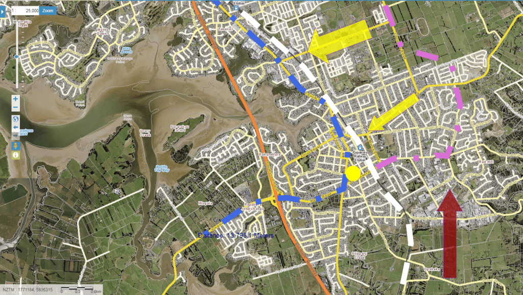
Manukau to Drury
This is where enhancing the Rapid Transit Network gets interesting and fun owing to the urban geography between Manukau and Drury. Fast population growth coupled by a constrained motorway and transit network make for congestion and frustration as people try to head north or south. It is not helped that the rail line and the sole FSN bus – the 33 run parallel to each other leaving large areas relying in infrequent feeders.
NZTA and Auckland Transport know this and that the Southern Line will not be able to handle the growth over the next thirty years. So being prudent they are investigating busways or light rail between Manukau to Drury to build resilience into the network.
Mill Road
Running frequent busses up from Papakura Station, along Mill Road and Redoubt Road to Manukau and back again is straight forward especially when you have east-west feeders along Walters, Airfield, Popes and Alfriston Roads connecting this new RTN route to either the Southern Line or the Great South Road proposed RTN. The 365 from Papakura to Manukau via Porchester Road still remains and today is seen as a damn good feeder and emergency bus to Manukau when the Southern Line or 33 bus packs up for whatever reason.
Weymouth/Manurewa/Manukau Light Rail Loop
To serve west of Manurewa a new Rapid Transit line from Manurewa Station, down Mahia and Roscommon Roads to Wiri Station Road before terminating at Manukau would capture an area not serviced by transit well as well as that area having good potential for mixed intensification under the Mixed Housing Urban zone.
The 33 Great South Road Bus
Depending if the 33 from Manukau to Papakura is replaced by Light Rail I would make this loop Light Rail as it connects with A2B straight away. As I said earlier the Weymouth/Clendon area is ripe for intensification and the road space especially on Roscommon Road has large grass medians for either road widening (rather not) or Rapid Transit (rather would). Given LRT has better intrinsic values then busses and bends in better to residential areas this new loop seems idea to tag on as LRT especially again as it connects with A2B.
The blue arrow (Weymouth Road) would be a feeder bus feeding into this new RTN route as well as Manurewa Station and the 365 bus.
Karaka the 33 and Drury
The Great South Road between Papakura and Manukau is an interesting one. It connects two Metropolitan Centres up and has varying land use from residential to Centres to light industry. It is also identified as a growth corridor given the 33 Bus and proximity to the heavy rail line.
However, this new RTN spine would go west at Papakura linking to Karaka (a fast growing area) to the network rather than going down to Drury. Drury can be easily handled by either feeding into the rail stations or a Great South Road bus running between Pukekohe and Papakura via State Highway 22 every 15 minutes.
Would this Great South Road/Karaka RTN line be bus or LRT? To be honest even with part of the northern route LRT it would be hard to say. 30 years time however, I could see LRT but for now a bus every 12 minutes is enough.
Of course we still have the Mill Road RTN linking to Papakura with busses also running every 12 minutes on peak and 20 off peak.
Papakura

Drury
Enhancing the Southern Rapid Transport Network
With City Centre to Mangere and Airport to Botany Rapid Transit both secured and soon to be underway it is indeed time to see how the Rapid Transit Network can be enhanced further south.
The Weymouth/Manurewa/Manukau Loop would be an excellent place to expand Light Rail from the Airport to Botany Light Rail line with both lines intersecting at Manukau forming a major transport hub. The excellent thing about this loops is it captures a very low density area that has road corridors designed for transport upgrades suited to medium levels of intensification nicely. Allowing intensification inside this LRT loop would take pressure off south of Takanini where the main transport constraints for transit and road are. Taking LRT from say Clendon to Manukau would take around 12 minutes where you can transfer to either the Eastern Line going north or A2B going to either to the Airport or Botany.
Further south got more tricky but nothing two Rapid Transit corridors (Mill Road and Great South Road) could not fix. For now the busses would be more than able providing the entire corridor had 24/7 bus lanes. Karaka would also be connected up.
Finally Drury has the Southern Line while Otara, Mangere, Papatoetoe and Otahuhu have modified bus routes forming crosstown lines linking up with one or more rapid transit lines.
Southern Auckland is the fastest growing and the largest sub region of Auckland. It is blessed by a good bus network and existing heavy rail system that will be further strengthened by Airport to Botany, and City Centre to Mangere rapid transit. But given the growth and employment potential taking a look at how we can enhance the the Rapid Transit Network south of Manukau is a must.
NZTA and Auckland Transport know this, I know this, the South knows this so LET’S DO THIS!