
I’ll start one
Last Thursday finally put to bed what had become a very myopic debate on relocating Port of Auckland to Northport in Whangarei some 170km to the north. With the Government concluding that North Port was most likely not the best option available and that more work would need to be done to even begin the formal processes of moving the Port, attention could turn back to matter at hand properly.
It should be known and accepted that the freight operations of Port of Auckland will move away from Downtown – a process that has happened to other Cities around the world (Sydney and London are two good examples). What will happen to the former Port land is for others to decide. Where the Port will go and how it will be supported is what I am more focused on.
Where are my Spatial Plans?
I have seen a lot of comments, reckons and even advertorials (from the NZ Herald) from urban elitists about the Port being moved but not a lot of comments being sought after by those either in the logistics industry or those who would be most affected by any Port relocation – the workers and business owners in Southdown and Southern Auckland.
To make matters worse is that I have not seen a single Spatial Plan from Port Relocation proponents that outlines how the Port would move, how the transport links would be formed and how subsequent urban development would shape up.
Now I know you are going to ask me straight away: Ben have you done any Spatial Planning on the Port Relocation issue? The answer is yes – now twice. Once in 2013-2016 in shifting the Port to the southern Tamaki Strait and having transport links run up the Papakura-Clevedon Valley to the existing rail and motorway links, and against just recently using the Firth of Thames option.
But before we go into what I quickly drew up over the weekend I will go into why a Spatial Plan is needed in the first place.
What is a Spatial Plan?
Spatial planning
Spatial planning systems refer to the methods and approaches used by the public and private sector to influence the distribution of people and activities in spaces of various scales. Spatial planning can be defined as the coordination of practices and policies affecting spatial organization. Wikipedia
Wikipedia
Urban Geographers by nature are Spatial Planners and usually are called in first to kick start the process either in reviewing existing situations or with their fellow Planners and Transport Engineers drawing up new methods and approaches.
So through Spatial Planning we are trying to influence (or find out the influence) the distribution of people and activity through a Port relocation (or determine that a relocation might be very well a dud). Once the Spatial Planning is complete it the project is then handed off to those who specialise in large scale infrastructure and urban development projects (the physical builds).
But to make Spatial Planning occur you need both an End and Start Point. In the case of the Port Relocation the end point is where the Port would be located, linked up with road and rail and any urban development to support it. The start point basically working backwards from the end point in testing the proposals and theories before any physical builds are done.
So where did I move the Port?
Let’s start with the end point:

The Pin mark is where the loading quays would be for the Port with the red line being the 3.2km long causeway connecting the quays back to the port facility itself. The reason for the causeway is two fold: 1) Protection of birds on the shoreline, 2) access to deep water which is availabe at the Pin mark (12.9m at the pin, 15m at the channel).
The port should still be on the Auckland side of the border however the urban development will be on both sides (meaning both in Auckland and the Waikato). As you can also see the Port would be close to State Highways 1 and 2 and the North Island Main Trunk rail line between Pokeno and Mercer.
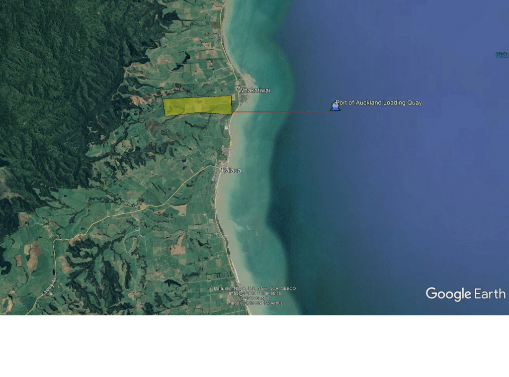
Next step is to lay down the port facility itself and connect it back to the causeway. The Port is inland and is around 105 hectares in size and 2.5km at its longest length. Again it is on the Auckland side of the border (which is about 500 metres to the south).
The port goes inland rather than straddling the coast for several reasons:
- Existing residential in the area
- Bird sancutuaries on the coast (hence the causeway)
- Climate change and sea level rise
- Direction of the new rail line to Auckland
- Subsequent urban development north and south of the port
Given the Port will still be an import port I have anticipated the movement of containers, cars, machinery and the occasional dry bulk. Wet bulk I would prefer be handled at Port of Tauranga and Northport while exporting logs is again Northport and Tauranga.
Now comes the fun part, the transport links and the supporting urban development for the port.
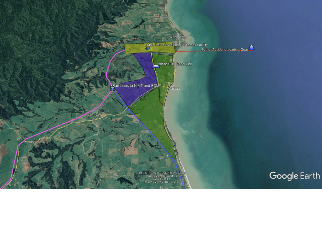
The road links use existing infrastructure that would be upgraded with the only new infrastructure being the Port access roads (stages 1 and 2). Kaiaua, Mangatangi and Thames coastal roads as well as State Highway 2 would be in for upgrades for the port traffic. State Highway 27 would also be upgraded over time as the port revs up to full operations.
The rail lines would be done in two stages:
- Rail line from the port to the North Island Main Trunk Line between Mercer and Pokeno. It does follow some old designations as it gets closer to State Highway 1 and the NIMT. The route also follows existing roads where possible and will need to cross State Highway 2 at Maramarua
- Rail line from the port to Morinsville via State Highway 27 where it would connect with the East Coast Main Trunk Line allowing connections to Tauranga and a second connection to Hamilton (useful if needing to access the proposed new inland port in east of Hamilton next to Waikato University
To support the port both industry and residential would need to be built. The blue is where I would house the industrial complex given proximity to the port, road and rail lines while the green would be the housing and amenities for the workers. If absolutely need be the residential can also go north of the Port but I would encourage intensification before promoting sprawl northwards.

The above picture shows the overall geography of the new port, the two rail connections and the road connections. As I said early the southern link would connect with the ECMT at Morrinsville to allow access to Hamilton East and Tauranga. This does mean I am sacrificing expendency by picking a longer distance in going to Morrinsville rather than cutting across the Waikato Plains straight to Hamilton. However, as I wanted a good connection to the ECMT heading to Tauranga the extra 20km of distance by going via Morrinsville I believe is worth it.
With that in mind here are the distances from the Port to various locations:
- Port to Wiri in South Auckland via Road: 70km (take off 15km if going to Drury South)
- Port to Wiri via rail: 80km
- Port to Hamilton East using rail via Morrinsville: 90km
- Port to Hamilton (Frankton Junction) using road or rail via Mercer: 90km
- Port to Tauranga via Morrinsville (rail): 140km (this is to the Port of Tauranga Mount Maunganui Main Wharves. Remove 9km for Sulphur point
- North Port to Auckland: 170-210km
- Port of Auckland to Wiri: 22km
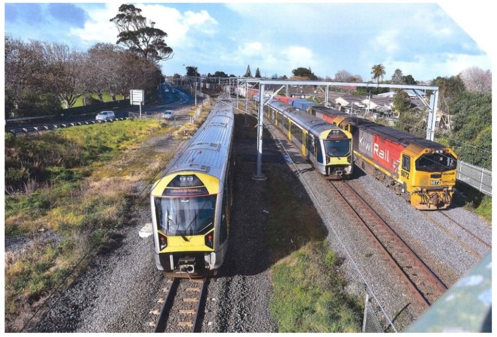
It should also be noted that the Third and eventually Fourth Mains will be built on Auckland’s Southern Line from Westfield to Pukekohe to detangle freight trains from passenger trains.
The Golden Triangle

Above is a diagram of the Golden Triangle where most of New Zealand’s population live, economic output occurs and growth in both is the fastest in all of New Zealand. Moving the Port to the Thames location puts it in a roughly-equi distance spot to the three main cities and their supporting logistics bases and industrial complexes. Notice how Northport is in the entirely opposite direction?
Also there is a reason why most of Auckland’s industrial bases is in Southern Auckland and follows the transport corridors to Hamilton and Tauranga – because they follow the population and subsequent markets.
Thus moving the Port south would be more optimum for not only Auckland but the Golden Triangle as well. Northland will still have Northport but as an export of Primary Products produced in Northland just as Tauranga exports Primary Products from the Bay of Plenty.
To shift the Port anywhere (but hopefully south) Spatial Planning needs to be conducted first. The reason for undertaking Spatial Planning is determine the influence the distribution of people and activity through a Port relocation (or determine that a relocation might be very well a dud). Once this done and thoroughly tested can we then begin the multi-decade task of moving the port, building the transport links and building the supporting urban developments (industry and residential).
With Spatial Planning we have an end point in a possible port relocation location and we also have starting point in undertaking the Spatial Planning itself and testing it for concept viability.
So before we get anymore hot takes on the Port can we at least get the Spatial Planning done first – you might find it answers quite a lot questions and give certainly for what would be New Zealand’s largest infrastructure and City Building project since the Christchurch Quakes!


I think if you built this megaport, you’d also look to close down large sections of PoT (especially Sulphur Point), basically make Whangarei and Tauranga local ports and PoA the upper North Island’s main port.
I think you have got the rail south wrong too. I’d go for your rail to Pokeno and then cut the corner from Taupiri to Matangi. This would then allow Auckland to BoP freight to bypass Hamilton. It would also allow Auckalnd to Wellington trains to stop in Central Hamilton with no turn around. This would make ~110km from the port to the Morrinsville Junction as opposed to your solution with ~65km. Youd need a full four lane motorway from Pokeno to the port and at that stage you may as well divert SH2 just south of Miranda and four lane it right through to the SH25 Junction.
Matangi? On my map that’s on the railway line (that was) to Cambridge. Do you mean Motumaoho, to the curve there ~6 km west of Morrinsville?
I do mean Matangi, which is where the Cambridge branch still joins the ECMT. The reason that I would bring it this close is because of the large inland port planned at Ruakura.
Great post Ben. Northport serves a function for Northland. Moving Auckland Port (and keeping in mind that some functions, such as the cruise ship business, will remain in the current Waitemata location) further away from the market makes little spatial sense.
You’ve made the inefficiency of having two major ports close together even worse by moving them closer together!
Talk about missing the point!
The port study has made very clear that three ports need to be amalgamated into two. The logistics industry supports this. And since Northport needs its rail link anyway, and the growth in Auckland’s industrial areas to the north and west of the city will rival the industrial south in size and scope, moving north makes the most sense.