
Extending Light Rail to Weymouth would uplift most socially deprived area of Auckland while also staving off further Greenfield sprawl further south
On Tuesday I wrote how Southern Auckland’s Rapid Transit Network could be enhanced (see: Enhancing the Southern Auckland Transit Network – By Expanding Rapid Transit Network South). It comprised of some simple fixes to existing busses in the northern half of Southern Auckland while some more substantial investment was needed in the southern half. That investment included two busways and a light rail line between Manukau and Drury.
In undertaking the Enhanced Southern Rapid Transit Network one factor remained at top of mind: Human Connectivity! Human Connectivity recognises that a rapid transit line is more than a bus down a busway or a train down a light rail line connecting A to B for the Monday to Friday commute but also one that allows easy equitable access to other non work destinations as well as enhancing amenity, civic spaces and opportunities.
I covered Human Connectivity as far as Airport to Botany Rapid Transit was concerned here: Human Connectivity – Which Way Is Best? Why Should (A2B) Light Rail Go Down Manukau Station Road and not Ronwood Avenue.
The Weymouth Light Rail Line

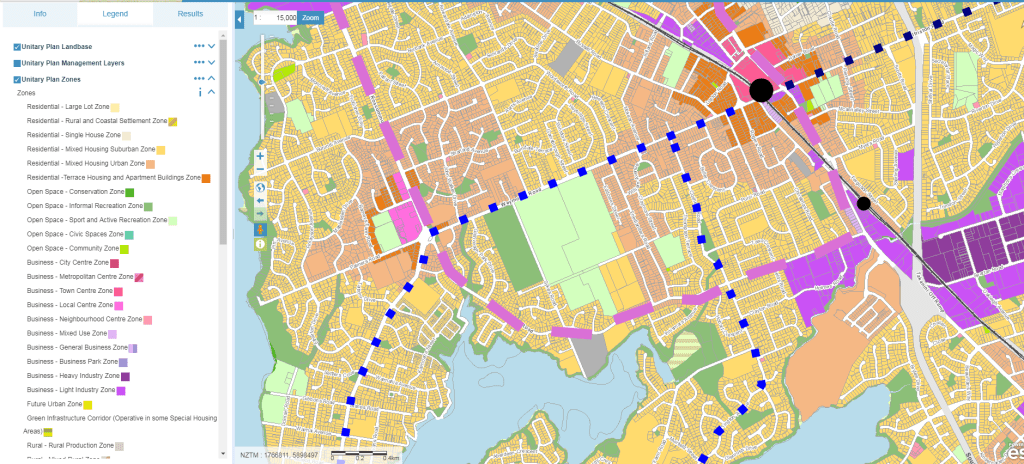
The Weymouth Light Rail line would run in a loop starting at Manukau Interchange (intersecting with Airport to Botany Rapid Transit) and head down the Great South Road through Manurewa Town Centre to the intersection of Mahia Road (Te Mahia Station is a short walk to the north). From there the Line would run down Mahia Road to the Clendon Roundabout before heading up Roscommon Road to Wiri Station Road before finally running along Wiri Station Road connecting back to Manukau. I have not decided to take the LRT Line to intersect with A2B at the State Highways 20/20B interchange owing to complexities from the Memorial Gardens Station that would be nearby.
I will say now the Weymouth Light Rail Line would have the 33 Bus run in parallel to it on its Great South Road leg, a service running from Weymouth to Manurewa Station via Weymouth Road, and a possible peak only service from Weymouth Road to the Manukau Memorial Gardens A2B Station but these can be seen as providing extra frequencies and resilience capacity in this constrained corridor.
Possibly in Decade Two (2028-2038) Light Rail might continue down the Great South Road to Papakura and Karaka but that is for another time.
Weymouth Line Urban Geography

The top one third of where the Weymouth Line would run is industrial with Manukau City Centre in the top right corner. For the rest the Line runs through low density residential plus the Manurewa Town Centre and Clendon Local Centre while intersecting with A2B, Manurewa Interchange and passing by Te Mahia Station.

Taking a closer look you can see the industrial quarter to the north with the low density residential to the south. The Line follows two major roads that go north-south linking the southern half of Southern Auckland to Manukau, Wiri, State Highway 20 and the Airport.
The blue dotted line would be feeder busses from Weymouth to Manurewa while the navy blue dots are the existing 365 that runs from Papakura to Manukau via Manurewa. The grey line is a future road and possible bus connection from Roscommon Road to State Highway 20B via Prices Road. This link once the Puhinui Gateway is built (light industry flanking SH20B) could be used to run feeder busses from Clendon to A2B for those needing to get to the Airport from the Weymouth end. This grey link showed up in the 2018-2028 Regional Land Transport Program as an unfunded activity.
Weymouth and the Unitary Plan

As noted earlier the top part of where the Line would run is industry with Manukau being in the top right corner. For the rest it is Mixed Housing Suburban and Mixed Housing Urban with some Terraced Housing and Apartment around Manurewa Town Centre and Clendon Local Centre. For the most part the residential area is around Weymouth Line is a half/half mix of the two before-mentioned residential zones. However, with lack of decent transit and amenity those areas will not intensify for a very long time. This is problematic as Auckland grows and we try and mitigate Greenfield sprawl south of Papakura that would have commuters otherwise come up the Southern Motorway or Southern Line.
By building the Light Rail line where suggested all residential zones within 800 metres of the line (apart from Wattle Downs owing to transport pinch points) that are not Mixed Housing Urban can be upzoned to the medium density low-rise zone while residential zoning within 400 metres of Manurewa and Clendon not already Terraced Housing and Apartments can be upzoned to that.
Weymouth Line building amenity – needed for intensification
Remember at the beginning how we need human connectivity? The same applies to the Weymouth, Manurewa and Clendon area captured by the Weymouth Line. We can upzone that is easy (relatively) but without the transit and specifically the transit mode that promotes amenity (thus attracting people to the area) then all we have are colours on a map and houses built as sprawl south of Papakura.
The Weymouth-Manurewa-Clendon-Homai area is prime for medium levels of intensification (terraced housing and low rise (3 storey) apartments. The area is in very close proximity to Manukau, Wiri and the Airport while also being near (but not very well connected to) existing rapid transit to go further north to places like Otahuhu or if need be the City Centre. The area also faces congestion (in part from traffic rat running from Papakura or Drury/Pukekohe trying to get to the airport – a problem A2B will help fix) so providing a Light Rail line would help beat those issues.

Most of all it is the amenity and civic spaces building and intrinsic value of Light Rail that would benefit the area the most. The Weymouth Line would prompt urban renewal that would boost investment in the area as well as Manurewa and Clendon. Boosted investment means more jobs and more resources to provide more and better civic spaces. In short the Line would act as a catalyst in lifting Auckland’s most socio-economically deprived areas into better well being. While at the same time and again better supporting intensification so that we do not need as much sprawl down south of Papakura.
Weymouth Line and Wiri

The Weymouth Line travels both through the guts of the Wiri Heavy Industrial Complex and the eastern side of Our Manukau that includes the Events Centre, Wero, new hotels and several residential subdivisions. The Light Rail line especially it linked up to A2B would reinforce those areas to a point that Wiri Station Road could redevelop into an Advanced Industries corridor.
Advanced Industries in the Auckland Plan is a set of industries concerned around IT, start-ups, population and health, Artisan (creative class) and food and beverage sciences (aka well paying employment). Advanced Industries need to be supported by high amenities and a decent transit system so it has access to a large population base. With Manukau City Centre in one direction, the airport in another and a large residential base to the south running the Weymouth Line through Wiri Station Road would catalyse industrial renewal.
Conclusion
The South is growing faster than anticipated. Auckland Transport and NZTA know this and I know this as well. To make the situation more dramatic we can not continue to sprawl south of Papakura however, our existing residential areas do not have the transit nor amenities to intensify. Enter the Weymouth Light Rail Line that connects the south west of Southern Auckland to employment and civic centres while building amenity to encourage urban renewal in Auckland’s most socially deprived area.

